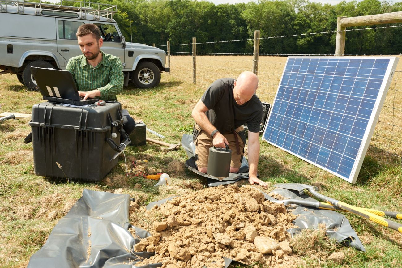
First seismic monitor installed in Surrey on 11 July 2018. Photo: Used with the owner’s permission
The British Geological Survey has installed two seismic monitors in Surrey to track earthquakes following a recent cluster centred near Newdigate.
The installation was welcomed by two campaign groups and the Green Party MEP for the region, Keith Taylor. They have called for an investigation into any links between the earthquakes and local oil and gas operations.
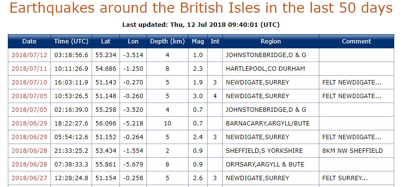
The most recent earthquake in the cluster was on Tuesday (10 July 2018). This is the eighth in the same area in about three months. The first was on 1 April 2018 and the largest so far, on 5 July 2018, had a magnitude of 3.1.
The BGS said the latest earthquake was recorded at just after 4pm and felt by a few people living in Newdigate and Charlwood in Surrey. They described it as:
“felt a thud and a very slight vibration through chair”
“slight impact followed by two or three seconds shaking, but much less obvious than previous ones”.
Of the past 10 UK earthquakes, four have centred on Newdigate. Before that, the county had no reported earthquakes for 50 years.
The BGS said of the new monitors:
“We hope to gain a better understanding of this scientific phenomena through the installation of additional stations.”
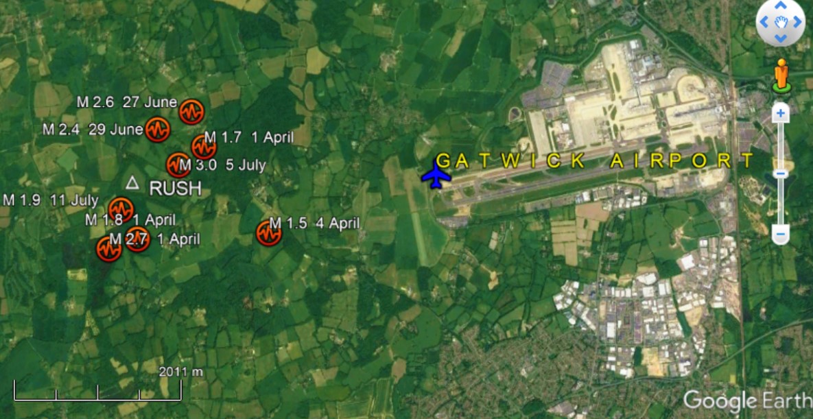
The first monitoring station, called Rush (white triangle), and the locations of recent earthquakes (red circles). Map base: Google Earth
The first monitor, installed yesterday (11 July 2018), is at Russ Hill.
Seismologist Dr Stephen Hicks, who was part of the installation team, said this was directly above the current best estimate for the epicentres. He said a second station had been installed in the Norwood Hill/Horley area.
Before the new monitors were installed, the nearest seismic station in the BGS network was on the East Sussex coast, about 50km away.
Dr Hicks, a postdoctoral research fellow in passive source seismology at Southampton University, said:
“The lack of close seismic stations means that we were unable to pinpoint the exact epicentre of the earthquakes. The locations had uncertainties of several kilometres and it was even harder to determine the depth at which they occurred.”
He said the depth of the earthquake, quoted as 5km, could actually be shallower or deeper. The new monitors would provide the best coverage of the seismic events:
“They will give us a good chance to determine accurate locations. The new stations will also tell us if smaller, previously unreported earthquakes are occurring in the swarm which are not being felt by people on the ground.”
Dr Hicks said the monitors would be in place for at least a few months, perhaps up to a year. If the data quality was good enough, they could become permanent, he said.
Data from both stations was now being sent to the BGS centre in Edinburgh, Dr Hicks said, and should be publicly available at some point on the BGS website.
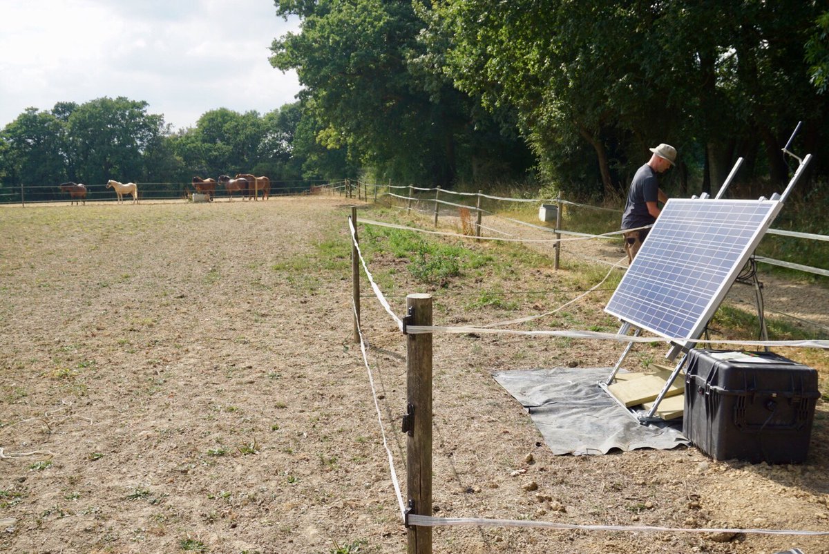
Second seismic monitor installed in Surrey today (12 July 2018). Photo: Used with the owner’s permission
The earthquakes have prompted calls for an investigation into any link with the county’s oil and gas industry. There are two oil sites within about 10km of the apparent epicentre: Horse Hill, near Gatwick, and Brockham, near Dorking.
Dr Hicks, who lives in Surrey, said
“In my opinion, based on past seismicity around the UK, the most likely scenario is that this earthquake sequence is natural and will die off in the future. But, we certainly cannot rule out future earthquakes. We have no way to predict when and where earthquakes are going to occur.
“Based on our knowledge about the type of hydrocarbon activities (e.g. Horse Hill and Brockham wells) in the area, and scientific studies of human-induced earthquakes around the world, there is no clear evidence at present to suggest that there is a directly link with the Surrey earthquakes.
“If earthquakes continue to occur, then thorough scientific analysis of seismic and geological data, combined with operational data from any industrial activities in the vicinity, will be needed to rule in or rule out any causative link.
“If the earthquakes continue in Surrey, data the new seismic stations will prove vital for further operational monitoring and future scientific studies about the different causes of earthquakes in and around the UK.”
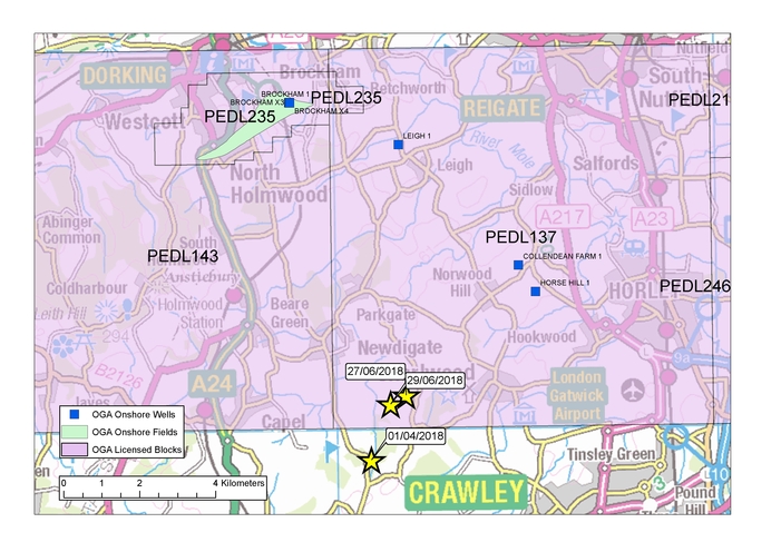
BGS map showing estimated epicentres of the earthquakes (yellow stars), PEDL areas (purple squares) and well sites (small blue squares)
James Hill, a member of the campaign group, A Voice for Leith Hill, said:
“Gathering local data is really important. We don’t know yet what started this period of seismic activity, but we know that the permits for the Surrey well sites were all approved before it was understood to be active for earthquakes.
“More worrying still is the possibility that a seismically stable region may have been turned into an active earthquake zone by some of the processes used by the oil and gas companies.
“Intensive techniques used to stimulate the flow of oil or gas from shale rock are under scrutiny here, as is the re-injection of contaminated waste water. Our geology is heavily faulted yet there are no rules to prevent drilling near these faults.”
“Whatever the cause, the regulators of drilling – the Oil and Gas Authority, the Health and Safety Executive and the Environment Agency – should suspend the licences to operate until it is certain that activities at these sites are safe. It is extremely risky to be carrying out any deep underground activities in an area where the geology is unstable.”
Another group, Brockham Oil Watch, said:
“No further planning permissions should be granted for exploration, appraisal or production from hydrocarbon development sites until the current swarm of earthquakes has been fully investigated and a protocol developed to minimise the risk of significant environmental harm from hydrocarbon development activities.
“All existing hydrocarbon development planning applications should be placed on hold until this protocol has been developed to an acceptable level of detail.”
The Green Party MEP for south east England, Keith Taylor, said:
“The seismic activity in an area where unconventional fossil fuel drilling and testing is active is clearly extremely concerning. It is also unprecedented in the Weald in the last half a century. At the same time, the links between earthquakes and the unconventional onshore oil and gas drilling industry are well established.”
“I welcome the British Geological Survey’s efforts here to further monitor this activity and would add that it is only sensible to put a moratorium on any oil and gas activity in the geological region until the results of the investigation are clear. The case for employing the precautionary principle couldn’t be any clearer.”
Categories: Research


JohnM
See ..’Deadly earthquake linked to groundwater extraction’. 2011. 7 Killed Spain.
So one could say that we know there is a link between water extraction and earthquakes, and that on the precautionary principle it should be stopped until a full investigation has been carried out.
But probably not for the weald unless some more info on where extracted, amount, and if more than usual etc etc. And even then …..