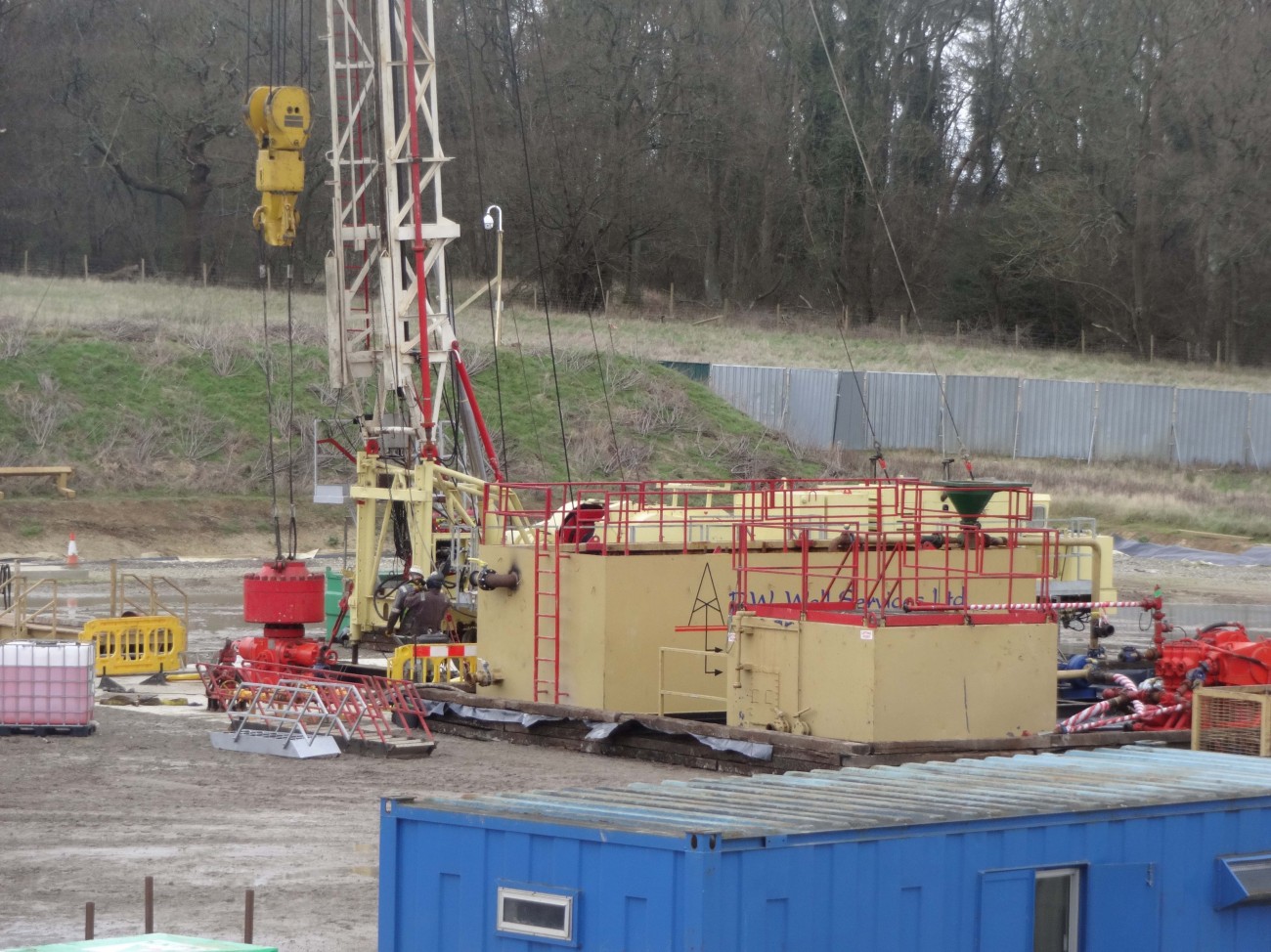
Flow testing at Horse Hill. Photo: Eddie Mitchell
In this guest post, David Smythe challenges the interpretation of faults around the Horse Hill “Gatwick Gusher” oil site in Surrey. He argues that the results of flow tests at the well can’t be applied to the whole of the Weald of southern England and predicts there will be no oil bonanza in the region without “wholesale fracking of horizontal wells”.
Introduction
For nearly three years, the press and the penny-investor bulletin boards have been excited by the alleged finding of a potential oilfield in the Weald Basin, bigger than the North Sea in oil content, below Surrey, Sussex, Kent and Hampshire. It started with the oil flow testing results reported from Horse Hill-1 (HH-1) – the so-called “Gatwick Gusher” – drilled by a partnership including UK Oil and Gas (UKOG) in the summer of 2014.
 What is surprising is that the ‘discovery’ implies that the traditional oil majors (see diagram) somehow collectively failed to find this gigantic Weald reserve during their explorations in the 1980s.
As Euan Mearns, an experienced oil industry observer, put it in early 2016:
“How could we Brits be so dumb as to miss 100 billion barrels just waiting to be pumped from under the home counties?”
The majors drilled right through the Kimmeridgian; they tested it; they had the long-reach horizontal drilling technology (witness BP’s Wytch Farm development in Dorset and out under Bournemouth Bay – the biggest onshore oil field in Europe); so why did they all miss it? It seems to have been left to a small investment group UKOG, plus a few related minor hydrocarbon exploration companies, to unearth this bonanza.
All the current petroleum exploration and development licences (PEDLs) in the Weald issued by the Oil and Gas Authority are classified as ‘conventional’. That means no fracking and no large-scale acidising (another form of ‘stimulation’). So since fracking will not be used (they say), there is no new technology available to UKOG that was not already known to BP, Shell and the other majors in the 1980s.
I decided to look into the geology of the Horse Hill discovery, but didn’t realise until I started that I was opening a can of worms. The resulting technical analysis is here.
Magellan and UKOG at fault
Magellan Petroleum formerly had a stake in HH-1. The Magellan interpretation of the geology from 2009 was modified by UKOG after the results of HH-1 came in. But UKOG made the fundamental mistake of retaining the prior fault pattern instead of throwing it out and re-mapping the geology from scratch. The diagram below illustrates the error.

The UKOG faulting is in mauve and the corrected fault pattern in blue takes proper account of all the seismic data and the results of Horse Hill-1. Teeth mark the downthrown side of the faults (click to start).
Magellan had interpreted the geology as comprising a higher-standing block called a horst, bounded to the north and south by faults. It also said that the old BP well Collendean Farm-1 (CF-1), dating from 1964, lay off the edge of the horst block.
BP had drilled in the wrong place, according to Magellan. HH-1 was planned to be drilled into the horst block. The Top Portland Sandstone was predicted to be about 100 m shallower here than at CF-1. But it turned out to be 18 m deeper. In the light of this result UKOG produced a re-interpretation, while retaining two Magellan faults running ESE from CF-1 (mauve toothed lines). But the more southerly of these now has an alternating sense of displacement (the downthrow), which is geologically untenable except in certain geological terrains which do not apply here. Going from west to east, the fault downthrows to the south, then to the north, then back to the south again.
I re-examined the seismic data to see where the faults lie. My version is shown by the two blue toothed lines in the animation above. There is a southerly Horse Hill Fault running just north of HH-1, and dying out to the west. The crucial evidence comes from a vintage 1962 seismic line very near HH-1 which Magellan and UKOG omitted from their database. It is of poor quality, but does the job.
CF-1 lies just to the south of a mauve fault, and also just south of my blue Collendean Farm Fault. There is unfaulted geological continuity from CF-1, traced on seismic data round the west end of the Horse Hill Fault, then back east to HH-1. BP did not drill on the ‘wrong’ side of the fault. The seismic continuity of the nearly flat layers west of HH-1 fits perfectly with the fact that HH-1 is deeper than CF-1 by 18 m.
So the two blue faults of my remapping are parallel and distinct; they run ENE-WSW, following the regional pattern. UKOG has indeed made a minor discovery of conventional oil in the Portland Sandstone, but it will need to re-map the geological structure from scratch, to then explain to its investors whether or not it is worth exploiting commercially.
What of the huge Kimmeridge ‘discovery’?
UKOG leans on calculations made for it by Schlumberger, a respectable oil service company, who estimated that in the whole Kimmeridge Clay Formation there was 176 million barrels of oil in place per square mile based on the HH-1 results. UKOG further declares that this oil will be exploitable by a curious concept of multiple deviated wells from each pad. Its picture is shown at approximately the same scale as the Jonah Gas Field, Wyoming, below left, and expanded on the right.
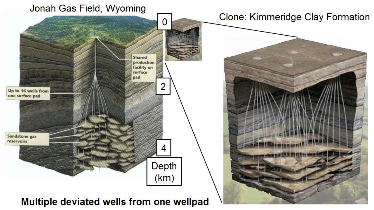
The UKOG deviated well concept for the Weald has been copied from the Jonah Gas Field, Wyoming
The giveaway in UKOG’s concept is their depiction of the Kimmeridge Clay Formation (KCF) as having a platy character, somewhat like a pile of overlapping chappaties. They appear to have borrowed the concept from the Jonah Gas Field, where tight sandstone lenses full of gas are exploited by multiple deviated wells.
The deviated Jonah wells are fracked to stimulate the gas flow. But this deviated well concept is useless for the KCF. Firstly, the scale is all wrong, because the KCF is 4-5 times shallower than the Wyoming sandstones, and secondly, the lens concept is completely inappropriate, since the KCF layers, in particular the limestone (micrite) layers, run laterally for 50-100 km without significant change. The tight KCF will require fracking of horizontal wells, drilled preferentially E-W, along the micrites.
As for the supposed huge reserve of KCF oil below the Weald; the oil in place has been estimated by Schlumberger on a per square mile basis. But how much area of a fractured fault zone can actually be drained from this single well? In addition, one certainly cannot extrapolate the fault zone flow results from HH-1 to the Weald generally. Using Schlumberger’s figure above, and a produceable reserve from the fractured tight KCF formation of 1% of the oil in place, HH-1 might be able, optimistically, to produce 177,000 barrels from the fault zone. In other words it might make enough to recover the costs of its exploration and development. This sort of figure might also be applicable along this and other fault zones.
Conclusion
The Gatwick Gusher’s results are anomalous because UKOG drilled a fault zone. It is irresponsible and misleading to apply those local flow results outside that and other similar fault zones, i.e in the 95% or more of the KCF which is not affected by a fault zone. There will be no KCF bonanza in the Weald – unless the countryside is indeed industrialised to permit wholesale fracking of horizontal wells throughout the region, with a 1-3 km well pad spacing similar to, say, NE Pennsylvania. But UKOG doesn’t want us to know that.
DrillOrDrop invited UKOG to respond to this Guest Post, which was first published on the Frackland blogsite on 26 August 2017.
DrillOrDrop welcomes guest posts. Please get in touch if you have an idea for a post or would like to respond to a report on the site.
Categories: Research


AI: You said previously:
“this is certainly not a “geological analysis” You do not mention porosity, permeability…”
Wrong again- what you mention here would be a prospectivity analysis. My analysis is geological, viz. the stratigraphy and structure, which clearly has to come first. Get that wrong, as UKOG did, and your prospectivity is meaningless.
I note that you have failed to answer my questions about the failings of Magellan/UKOG – presumably because you agree with me.
All right – perhaps about one month, not several, required to do a thorough job of the Brockham-Horse Hill area, of which a large part would be getting the static corrections right between the various survey vintages, and reprocessing, say, one line. The actual mapping, having done that preparatory work, would be just a few days. My consultant’s fee would be a tiny fraction (less than 1%) of the drilling cost, so money well spent. How much did UKOG spend, either in-house or bought in, for the rubbish they have produced?
“….you failed to answer my questions about the failings of Magellan – presumably because you agree with me.”
This is not a logical statement.
In the interests of full disclosure, let me start by stating that I have spent many years in the oilfield as a Drilling Manager / Superintendent / Engineer.
My work has in the past included drilling several Wells Onshore the UK in the late 1980’s and early 1990’s, but I have been working Overseas for many years and have never worked for any of the Companies currently undertaking drilling campaigns in the Southern UK.
I have not contributed to this bulletin board until now. However, the article posted by Professor Smythe and his attitude towards other posters irritated me to the extent that I felt it necessary to respond.
Professor, firstly, your pejorative language E.G. “dog’s dinner” & “Pigs ear” in describing UKOG’s interpretation is unbecoming of a professional and merely detracts from your argument.
As also stated by another poster in this forum, I am used to seeing G&G arguments presented with many qualifiers. To be so definitive in asserting that you are correct, and that they are not, is just wrong.
To go onto your article;
You are quoting Euan Mearns out of context. He was actually asking a rhetorical question at the start of what is a very good article he wrote about oil in the Weald Basin and Horse Hill-1 (which he called a ‘nice conventional discovery’) in particular.
With respect to the knowledge and technology available to BP and the other majors in the 1980’s, you are incorrect.
Since then, the technology available with respect to – to name a few – drilling fluids, drilling tools, drilling techniques, E-Logging equipment & log interpretation has improved by at least an order of magnitude and we now do things routinely (especially with respect to horizontal drilling) that were simply not possible then.
The Kimmeridge was well known as a source rock, but it was not well recognized (if at all) that the Limestones could be a potential reservoir. Indeed, from a drilling perspective, they were far better known as a potential lost circulation zone which needed to be bridged off with lost circulation material.
The Electric Logging technology that was available back then was very poor at identifying natural fractures – I don’t actually recall ever running the imaging tool that might have been able to do so.
The conventional E-Logs available lacked the resolution to tell what type of fluid would be in the matrix porosity of the Limestone, and any natural fractures would have been clogged up by us Drilling types with LCM, thus distorting the E-Log responses…
As an aside, on that subject, UKOG will indeed have new information available that you do not – specifically the E-Log Sonic (and VSP, if one was run) data from the HH-1 Well. This will no doubt have been used in their new structure model.
The first horizontal Well was not drilled Onshore the UK until around 1991 – long after the Majors had left the Weald Basin due to the oil price collapse.
Even so, horizontal Wells were still a niche technology until the late 1990’s when drilling horizontal Wells in the Austin Chalk in the USA really developed the tools and techniques needed for horizontal drilling to enter the mainstream.
In fact, development of the Austin Chalk would be a direct analogy to a potential development in the Kimmeridge Limestone – drilling horizontal wells to penetrate as many naturally occurring fractures as possible.
With respect to the PEDL’s issued by the OGA, does a ‘conventional’ license classification mean that frac jobs or acid washes cannot be performed?
Since returning to the UK, I must admit to have been very surprised at the outcry over fracing here. Are people really not aware that around 200 Wells Onshore the UK (including some in Sussex and Hampshire) have already had frac jobs performed on them? And that many Wells (probably a majority) in Sussex and Hampshire have had acid washes? But I digress.
So, the statement that there is no new technology available to UKOG is fundamentally incorrect.
UKOG didn’t refer to the Jonah Field – they originally took a generic field development diagram that has been applied to many field developments all over the world – it was YOU who specifically tied it into the Jonah Field.
It could equally have been titled ‘Forties Field’ or ‘Welton Field’, or any one of a thousand other fields in Production around the World.
However, it is irrelevant, as you should have used the slide (No. 15) from UKOG’s most recent presentation (May 2017) on their Website.
Click to access Corporate%20Presentation%20May%202017.pdf
This clearly, and correctly, shows that horizontal and high inclination Wells would be used to develop a Kimmeridge Limestone Field.
It has been available on the UKOG website for over three months, so why didn’t you use it?
Even though the Kimmeridge Limestones are at a relatively shallow depth, current drilling technology means that horizontal legs of 2,000+m should be easily obtainable. This greatly increases the areal extent that each Well Pad could cover, thus significantly reducing their number.
The testing of Broadford Bridge-1, plus the drilling and testing of Holmwood-1 and other Wells by Angus Energy will go a long way to establishing if this indeed a valid play concept for the Weald Basin.
Until then, people can speculate all they want – but speculation is all it is and claiming that HH-1 is commercially barely viable is far too premature.
In the meantime, trying to equate potential development projects in the Kimmeridge Limestone with fracing is, at best, being disingenuous.
Finally Professor, you claim that none of the posts have challenged your model.
Well, here you go (this also includes a rebuttal of some of the other statements made in your article and posts);
Page 1
‘Geological analysis of the Horse Hill prospect’. In fact, your presentation should be more accurately titled ‘An alternative Geophysical model’. It is certainly not a geological analysis and if anyone had come into my office with such a presentation and tried to pass it off as such, they would have been given very short shrift indeed.
Page 2
‘The predicted closure area is based on just three 2D Seismic lines’. No, the other seismic lines were also used to define the limits of the closure area.
Page 3 & 4
The fault interpretation is described as very different when in fact they are remarkably similar. In addition, you are referring back to the Magellan prediction of 2009, whereas UKOG produced a revised version in
Page 5
You describe the apparent throw of the fault changing from one direction to another and back again as being highly unusual. Perhaps it is just the areas I have drilled in, but I have seen exactly this several times during my career. I would agree it is not common – but that doesn’t mean it did not happen here.
I should point out that both the interpretations (also on page 6 of your presentation) hangs on the apparent top of Portland being 18m deeper on HH-1 than on CF-1. Without access to all the CF-1 data, I would point out that there are several potential errors on the quoted top Portland for CF-1.
A) Is the depth referenced quoted as TVDMSL, MDMSL, TVDRT or MDRT? I have seen many instances in old well records where we were unable to definitively identify what the datum used for depths quoted actually was.
B) Does the top Portland quoted in the CF-1 Well refer to the Portland Limestone, Portland Sandstone or possible even the top of the Portlandian, which actually includes some of the Purbeck Group? I recall this was always a topic of discussion in the 1980’s when I was involved in drilling some Wells in the Southern UK. There was also some discussion about whether or not the Purbeck Anhydrite should actually be called the Portland Anhydrite for just this reason.
Page 7
I would point out that the throws associated with the fault (as marked by yourself on page 6 of your presentation) are actually quite small – certainly in the vicinity of the apparent change in direction of fault throw, such small throws are very difficult to definitively image on 2D seismic of this vintage – there may not even be anything there at all.
Question – are you sure that the UKOG G&G group (or their subcontractors, if the work has been farmed out) are still using the old IHS Kingdom program? I’d be surprised if they are.
Also, it would be more correct for you to state that “in my view, the mapping of the CFF is fundamentally flawed”, as there is clearly more than one interpretation and it is not possible to say which (if either) is the most accurate.
Page 8
You make the statement that most of the mauve faults are not credible, but do not state your reasoning behind this. It can certainly be seen that there is a lot going on in the SP 240 – 300 area and so it’s difficult to definitively state if any particular fault is there or not.
Page 10
You make the claim that your revised fault interpretation shows that Well CF-1 lies on the upthrown side of the CF Fault. Yet you ignore that SP 250 looks busy from 300ms downwards, and that there is good reason to suspect a fault – possibly the main CF Fault – extends diagonally from SP 250 at 400ms, down to SP 270 at 600ms. This would potentially put the CF-1 Well on the downthrown side of the fault, as per UKOG’s interpretation.
Page 11
Considering how ‘busy’ the area is, it looks like there actually is little difference between UKOG and your placement of faults – just the interpretation of how they are connected between the seismic lines.
Page 12
The Esso line is not used by UKOG – I suspect because they QA/QC’d the data and were not confident in its validity. They certainly did not ‘forget it’ as you claim. However, if you are confident, why not use it instead of line C80-130 try try and cross-correlate? Although it is a little further from the CF-1 Well than line C80-130, the intersection between it and line BP-85-74 is 1km closer to HH-1 and therefore much more valid.
Page 13
A static correction of +25ms has been added to the BP line. Why? This is quite large considering how shallow the top Portland SST is. If the static correction is removed, then the correlation is poor.
Page 14
You admit that data quality from the Esso line is poor (which is likely to be the reason why UKOG did not use it), and I feel a case could be made for the same error in scalloping of the reflectors could have happened in trace 440 – 460 and trace 520 – 540. However, you use this seismic data to pick two major and two minor faults.
You and I both know that I could give this same Seismic data to ten G&G personnel and get back ten very different interpretations of where the faults are.
Page 15
This is your interpretation. You state that the UKOG interpretation is untenable, but from the data in your own presentation it is relatively simple to make a case for a fault running along C-I-J-K as per the UKOG interpretation.
I am not saying that they are correct and you are wrong. It is just that cases can be made for both and it is therefore incorrect to definitively state that one is untenable.
In any case, depth based contour lines are really needed to produce a valid map. I am sure you are aware that time/depth conversion using Sonic log and VSP data sometimes means that formation tops on one Well may appear higher than another Well when presented in time format, but are actually deeper due to velocity changes across the field and/or faults.
Page 16
As above, it is not correct to state that UKOG’s interpretation of this particular field (it is no longer a prospect, as oil has been found) is untenable – just that you have a different interpretation.
That the UKOG Geologists have modified their pre-existing fault maps with new data is unsurprising. I have seen this in virtually every Exploration Well I have been involved in, as it is only human nature to use the model that you have started with and only change it when confronted with sufficient data to show it is fundamentally flawed (“The bloody XXXX Formation came in 1,000m high – your model is BS!!!!”….).
While a discovery has been made in the Portland, it is not correct to try and call it a minor (or anything else) discovery until, at the very least, flow testing has better established the potential reservoir limits.
Further clarity on the reserves could then be gained by revisiting the model with this information and – later on, by a combination of drilling another Well, side-tracking the current HH-1 (unlikely – I’d keep it as a producer), reprocessing current seismic data with the computational power and new velocity information from HH-1 available and, finally, possibly shooting more seismic over the structure.
In the third paragraph on page 16, you state that the flow from the Kimmeridge is due to drilling HH-1 close to the HH Fault; it is the fault that has enhanced the fracture permeability (technically you should state ‘the number of fractures and their size’) and it is just a local effect.
This is nonsense. In my experience, any rubble zone that may exist around a fault is very small (just a few m in diameter) and HH-1 is not close enough to see this effect.
Indeed, if a rubble zone of the magnitude you imply existed around the HH Fault, then any oil in the structure would have migrated out long ago – especially along such a near vertical fault.
In any case, there does not need to be a fault close by for a natural fracture network to exist in a formation.
With regards to the last paragraph on page 16, you use a lot of qualifiers used to come up with a potential 170,000 bbls produced from this Well (in other words, you are implying it is sub-economic), and I am afraid this is also nonsense.
Any Reservoir Engineer would wait until the test data was available before trying to estimate the fracture volume being drained, and from that work out potential recoverable reserves. The reserves recoverable not only depend on the extent of the fracture network, but also the matrix porosity and permeability of the fractured formation.
In some of the hugely prolific fields in the Middle East, similar Wells have produced for years. But if there is a water leg in the field (and no apparent evidence of that yet at Horse Hill), they may water out after only a few months of production.
Page 17
See earlier comments.
Page 18
Your conclusions are, quite frankly, wrong.
Irrespective of which fault model is correct, you clearly do not understand the nature of natural fracturing and how it can be used to exploit the gas or oil present in a structure, and you reference a development model which UKOG are not going to use.
It is a pleasure to respond belatedly to this detailed technical comment. I was only made aware of it on 2 October, which is why I had not responded sooner.
I have now replied in detail to Injuneer on my frackland blog (http://www.davidsmythe.org/frackland/?p=435), because the whole commentary is far too long to put on this post. It also includes several new diagrams.
What particularly amuses me is the effort some relatively poorly-qualified people like Injuneer make to try to refute my Horse Hill analysis, whereas no properly-qualified individual either dares or bothers. His (or her) evident lack of geological or geophysical experience and training is revealed by the fact that only two minor points out of his 31 points of criticism (my numbering) are valid, and a further two are debatable.
The problem with Injuneer’s detailed comment, which runs to some 2500 words, is that it fools some others [edited by moderator] into thinking that it is valid, because it has a veneer of expertise.
I note the ongoing lack of response from anyone from UKOG, who would be the most appropriate person to reply, and who were invited by Drill or Drop to do so. Perhaps they are busy re-drawing all their maps, and will eventually publish corrected and non-misleading investor information.
Injuneer, Thank you for giving a very thorough and informed technical response to Prof Smythe. He said he would only reply to technical comments on his guest post. He has not yet done that. I waited for several days since your post. Still no reply from Prof Smythe. So in the deafening silence I just want to say; well done!! You appear to have silenced him, although I would much prefer that he replied to your post – may be he will???!. My only pedant picking at your excellent post is that horizontal drilling onshore UK was happening in the 1980’s. It was really cutting edge & experimental then, and I was called out in the night to help steer a UK onshore well being horizontally drilled. Note also that the UK’s largest onshore oil field has produced far more than the OOIP estimation due to horizontal drilling (underneath the the highest value private property real estate – without affecting property prices- for the record I was not involved in that wonderful oilfield).
Dr Riley – sorry about my delay in replying – please see my response above to Injuneer, and enjoy my latest frackland blog post about it.
The good news is that, if drilling continues, we shall find out who was correct I guess?
Plus, INEOS look like the best bet for any success with Shale Gas, due to their extensive 3D Seismic Activity, followed by exploratory drilling etc.
Many industries are performing these activities nowadays but I want to say is that not destroying our nature and if yes then why we perform these activities. We are just contributing for ourselves but we are not contributing anything of nature.
[Edited by moderator]
Excellent post. I am going through some of these issues as well..