
Well testing at Horse Hill in 2016. Photo: HHDL
Plans for more drilling and testing at the exploratory oil site at Horse Hill, near Gatwick Airport, were published this morning.
DrillOrDrop has picked out key facts from the 62 documents that make up the planning application to Surrey County Council. The full documents can be read here. In future posts, we’ll report on reaction to the application and its progress through the planning system.
Application details
Applicant
Site operator: Horse Hill Developments Ltd, a special purpose company formed of six shareholder companies, of which the largest is UK Oil & Gas Investments PLC with a 48% stake.
Agent: Barton Willmore LLP, Cambridge
Application reference: Surrey County Council 2016/0189 and link
Application description: Three-year application to retain wellsite and access; appraisal and flow testing of the existing Horse Hill-1 well (HH-1); drilling of a sidetrack to HH-1 and a second, deviated borehole followed by flow testing; installation of security fencing to a larger area plus acoustic and light barriers, plant, cabins and equipment; restoration to agriculture and woodland.

Image: HHDL
Site
Address: Horse Hill 1 well site, Horse Hill, Hookwood, Horley, Surrey RH6 0RB
Size: 2.08ha – extended by 0.78ha to include additional security fencing and realigned access road
Location: 3.1km from Horley town centre, 2.3km from the village of Charlwood and 1.6km from the village of Hookwood, 2.2km from Gatwick Airport
Nearest homes: Wrays Farm House (370m), Fiveacres (410m), High Trees Court (350m)
Nearest business: Lomond Equestrian Centre (0.16km)
Access: 250m access track to meet Horse Hill road
Protected landscapes: The site is in the Metropolitan Green Belt. The Surrey Hills Area of Outstanding Natural Beauty is 6.99km away and 4.76km from the Surrey Area of Great Landscape Value
Rights of way: A public right of way runs along the southern boundary of the site and another is 400m to the north
Landscape Character Area: Dorking to Hookwood Low Weald Farmland Landscape Character Area
Nearest designated wildlife site: Edolph’s Copse Local Nature Reserve (1.8km), Mole Gap to Reigate Escarpment Special Area of Conservation (9.04km), Glovers Wood Site of Special Scientific Interest (2.81km), plus six Sites of Nature Conservation Importance within 2.5km.
Nearest heritage: Horse Hills and Woodlands Farm Houses (560m), Scotchman’s Copse – medieval tannery (4.17km), Reigate Priory historic garden (3.6km), plus 13 listed buildings within 1km.
The application mistakenly says Stansted Park Grade II registered park and garden is 900m away – this information is from the UK Oil & Gas application for Markwells Wood, also prepared by Barton Wilmore
Flooding: Flood zone 1 (low risk of flooding). At the EA’s request, a drainage pipe is to be installed in the gravel swale in the site on the west edge
Groundwater: The site is not in a groundwater source protection or vulnerability zone but it is in the Lower Thames Drinking Water Safeguard Zones established to protect drinking water from pesticides
Site description: Hard standing of existing HH-1 wellpad, with soil bunds, security fencing and access road
Surroundings: Farmland, hedgerows and woodland, with two small ponds in surrounding woods and Spencer’s Gill, a tributary of the River Mole, 590m to the south
Petroleum Exploration and Development Licence area: PEDL137

Protests during flow testing in spring 2016. Photo: David Burr
Planning history
16 January 2012: Surrey County Council granted planning permission for exploratory wellsite with one borehole and short-term testing (reference RE10/02089)
Autumn 2014: Horse Hill-1 well drilled and oil discovered in Portland Sandstone and deeper Jurassic formations including Kimmeridge limestones
February/March 2016: Flow testing resulted in nearly 1,700 barrels of oil equivalent per day – the highest of any UK onshore exploration discovery well
16 May 2016: Pre-application meeting with Surrey County Council planning officers about further proposals for the site, including extended well tests and new wells
28 June 2016: Surrey County Council confirmed an Environmental Impact Assessment was not required
21 July 2016: Public exhibition about the plans at Charlwood Parish Hall, 2pm-7pm
14 October 2016: Latest planning application submitted
27 October 2016: Latest planning application validated

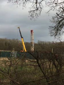
Rig section. Image: HHDL
Development proposals
Phase-1: 210 days in total
- Site enabling works
- Erection of security fencing to a larger site area
- Installation of 81m long, 6m tall, 1.5m wide acoustic and light barrier along southern boundary of the well pad
- Removal of 2 trees to south of well pad for security reasons and a group of other trees to straighten the access track
- Installation of security cabins and welfare facilities, including diesel generator and toilets
- Installation of temporary offices, living accommodation, canteen, toilets, shower, laundry and waste tanks
- Workover
- Workover rig to make new perforations in HH-1 well
- Installation of flow test and rod pumping equipment
- Rig expected to be about 32m
- Acidisation
- Use of coiled tubing unit to acidise the HH-1 borehole.
- The application says this is to clean out cement debris from perforations and enabling oil to flow more freely into the wellbore
- Pumping of 15% hydrochloric acid solution into the well
- Spent acid returned
- Waste sent to licensed site
- Extended well test
- Equipment installed, including flare stack, pumps, degasser, settling tanks, separators
- Extended well test of HH-1 to confirm whether volume and flow of oil is economically viable
- Pumping may be required
- Oil and produced water removed by road tanker
Phase 2 (dependent on outcome of phase 1): about 100 days in total
- Mobilisation of rig (BDF51 or similar), 37m high
- Drilling deviated sidetrack from existing HH-1 borehole
- Workover of HH-1 sidetrack well
- Acidisation using coiled tubing unit to HH-1 sidetrack
- Extended well test of up to 75 days to HH-1 sidetrack
Phase 3 (dependent on outcome of phase 1): about 110 days
- Construction of new well cellar next existing HH-1 cellar
- Mobilisation of rig
- Drilling new appraisal well, Horse Hill-2 (HH-2) from existing well pad
- Workover of HH-2
- Acidisation using coiled tubing unit to HH-2
- Extended well test of HH-2 for up to 75 days
Phase 4 (if the oil is not commercially viable): Up to 22 months
- Decommissioning of site
- Wells plugged and abandoned
- Removal of equipment, structures, access roads and impermeable membrane
- Replanting of trees
- Restoration to agriculture and woodland
The application said the phases may not be carried out consecutively and phases 2-4 may not follow immediately after the preceding phases.
Future production
The application stated:
“In the event that the appraisal programme demonstrates commercial viability HHDL intends to submit a further planning application for a production phase in due course.”
Traffic
The transport statement says there will be 10 heavy goods vehicles (HGV) going to the site and 10 leaving every day for the 14 month operational phases of the development.
The application acknowledges:
“There will be an increase in traffic movements mostly during rig mobilisation and demobilisation, resulting in minor effects from disturbance and delivery of unconventional loads although this will be managed through a Transport Management Plan”.
It added:
“The temporary increase in traffic volumes and especially the HGV component of the traffic volume could lead to adverse highway safety impacts”
But it concluded that the development would generate a 0.11% increase in traffic on the A217 north of the junction with Horse Hill and a 0.59% increase in HGV traffic.
The application said HGV movements would be 7am-7pm Monday-Friday and 7am-1pm on Saturday.
The application gives the following maximum traffic movements, where one movement counts as two journeys, one in and one out
Phase 1
- Site preparation: 20 in total over 30 days
- Workover and extended well test for Portland formation: 10 per day for 68 days
- Demobilisation for Portland formation extended well test: 20 over 2 days
- Mobilisation for Kimmeridge formation extended well test: 20 over 2 days
- Workover, acidisation and Lower Kimmeridge extended well test: 10 per day for 76 days
- Demobilisation for Kimmeridge formation extended well test: 20 over 2 days
Phase 2
- Mobilisation for HH-1 sidetrack: 50 over four days
- Drilling sidetrack: 10 per day for 25-35 days
- Demoblisation for drilling HH-1 sidetrack: 50 over four days
- Mobilisation for HH-1 sidetrack extended well test: 20 over 2 days
- Workover, acidisation and extended well test: 10 per day for 75 days
- Demobilisation for HH-1 sidetrack extended well test: 20 over 2 days
Phase 3
- Mobilisation for HH-2 drilling: 50 over four days
- Drilling HH-2 well: 10 per day for 35-45 days
- Demobilisation for drilling HH-2: 50 over four days
- Mobilisation for workover, acidisation and extended well test for HH-2: 20 over 2 days
- Workover, acidisation and extended well test for HH-2: 10 per day for 76 days
- Demobilisation for workover, acidisation and extended well test for HH-2: 20 over 2 days
The proposed transport management plan would set out an agreed access route, scheduling of HGV movements to avoid peak traffic, signage to identify access routes and a code of conduct for drivers.

Estimated lorry movements. Source: HHDL
Proposed working hours
Phase 1
Site preparation: 7am-7pm Monday-Friday, 7am-1pm Saturday
Extended well test: 24-hours a day, 7 days a week
Phase 2
Drilling and extended well tests: 24-hours a day, 7 days a week
Phase 3
Drilling and extended well tests: : 24-hours a day, 7 days a week
Phase 4
Site clearance and enclosure of wells: 7am-7pm Monday-Friday, 7am-1pm Saturday
Waste
The application said solid and liquid waste would be stored on site in sips or tanks before being taken off-site for disposal.
Gas produced by the extended well tests would be flared in a 10m high flare stack.
Noise
The application said noise during site preparation could be classed as “minor adverse significance” because operations may be audible at nearby homes.
During drilling, the sound of the rig may be greater than background levels at night, the application said. Without acoustic screening, noise would exceed nighttime noise limit of 42 decibels at the nearest homes and would count as moderate adverse significance.
During the extended well test, the application predicted noise would be similar but not exceed, that in the drilling phase and was “unlikely to be audible beyond the site boundary at any time”.
It forecast that the following noise levels would be met with the acoustic screen in place on the southern boundary:
- Site preparation and retention: day 65db; no work scheduled in the evening or weekends
- Mobilisation, workover, and drilling: day 48db, evening and night 42db
- Extended well tests: day 48db, evening and night 42db
The application added:
“Further measures to mitigate noise will be applied at source where possible including turning off engines when vehicles or equipment are not in use and reducing the drop height of materials.”
The application said vibrations from the site would “not be perceptible” at the nearest homes.
Lighting
The planning statement did not specifically say that the site will be lit at night. It did, however, say the rig would be lit and lighting would be positioned inwards and downwards using the lowest level required. A 6m lighting barrier would be installed along the southern boundary.
It said lighting would be switched off at night where possible. Lights would be selected that had “minimal disturbance” to bats, the application said.
It concluded:
“the overall effects of the development’s lighting would be minimal as the site is located within a woodland area. The significance of impact in terms of sky glow would be minor to moderate adverse and the impacts in terms of light intrusion and luminaire intensity would be negligible”.
Air quality
The application concluded that emissions from flaring during extended well tests would lead to increases in pollutants, particularly nitrogen dioxide and PM10 and PM2.5 particulates.
But it said with mitigation the “effect of these increases in concentrations on existing sensitive human health and ecological receptors has been shown to be insignificant.”
The application added that there would be no significant impact of dust from site construction with suitable measures in place. Road traffic emissions were considered “insignificant”.
The site is 2.26km from the South West Horley Air Quality Management Area, designated in 2003 because of nitrogen dioxide concentrations.
Heritage
The application said:
“The development of the Site as an onshore oil exploration well site in 2014 has already altered the character of the Site itself without significantly changing the character of the surrounding landscape, and it is not considered that further works will impact upon the historic landscape character type as a whole.”
Ecology and nature conservation
According to the application, six species of bats were recorded within 4km of the site. There were also records within the area of dormice, hedgehogs, protected bird species, smooth newt, common frog, grass snake and great crested newt. It acknowledged evidence of badgers in neighbouring fields and woodland but said no active sets were found within 100m of the site.
The application recommended moving a population of great crested newts which used the attenuation ditch on the site.
The application concluded that with mitigation the development would “meet all current legislation and planning policies relating to ecology.”
Impact on views and landscape
The application said:
“There will be some views of the drilling rig during operations, although lower and middle parts of the rig and site will be mostly screened from view by woodland and topography. The greatest potential for adverse effects is likely to be upon users of the local PROW to the west of the Site, extending to the route that follows parallel with the southern boundary. The proposed acoustic/light barrier will provide mitigation that will reduce the impact of the visual effects of the Development.”
Water and flooding
The application said there were no licensed water abstraction points within 1km of the site. It added that the area was “not characterised by a significant use of groundwater for water supply purposes”.
A risk assessment by the applicant of water contamination concluded that with mitigation there was a negligible risk from all activities on the site.
It also concluded that the development would not increase run-off rates or volumes of surface water from it.
Public consultation and decision
Surrey County Council confirmed that the public consultation on the application opens next week. The usual duration is 21 days. The council said the deadline for comments had not yet been fixed but would be given in notices in local papers and at the site.
The council said the earliest date for a decision by the planning committee was 22 February 2017. But the decision date could be delayed if further information were needed for the application.
Link to application and consultation information
Categories: Regulation


Chris Crook, you are sadly mistaken over a number of things not least the millions of children livings BELOW the official poverty line in this country! Get your facts right. The Exec Chair and CEO has ALWAYS said no fracking and the depth of the Portland and Kimmeridge is in any case above 1000m. THEREFORE it is against the law to frack these targets. I suggest some further education is needed on your part as to the techniques of 21st century conventional oil extraction. You lack of knowledge here is illuminating!
Gordon, you really are silly when you stick rigidly to the definition of Fracking. Just because someones changes the definition it doesn’t mean you are not still doing it. [ Edited by moderator] Look at Angus [ edited by moderator] putting up new buildings without planning permission. You can’t trust any of them. I’d sell up quick before you lose your money.
Mrs shepherd I suggest you do some more research! By utilising modern spider multiple bore technology from a wellhead unobtrusively installed subsurface is 21st century technology many conventional targets can produce simultaneously. It is not fracking. It is completely ECO friendly in terms of the local environment. Oil is needed by our country to support the renewables revolution, which will take at least 20-25 years to mature. Hopefully by then we will have invented alternatives to plastic, detergents, lubricants, electrical components and hundreds of other bi-product sub groups to finally mean oil is no longer needed. But for now, educated folk understand the need, and the fact we will become self sufficient in oil and gas in years to come (as our demand diminishes) leading to a phenomenal saving in terms of our carbon footprint from NOT having to import our energy.
Those folk here who are against UKOG for reasons which do NOT stand up to scrutiny I ask once again……
Might I suggest you take some time to engage with UKOG who are leading in communications with the local community and other stakeholders. Information is easily accessible and I wonder if you participated in any of the locally organised meetings to date? Try here:
http://www.ukogplc.com/page.php?pID=4
http://www.ukogplc.com/page.php?pID=100
Did ANYONE participate?