
Montage: INEOS
Plans by INEOS to drill an exploratory shale gas well in north Derbyshire have been published by the county council.
But the application – the first of its kind in Derbyshire and the first submitted by INEOS – is not yet open for public consultation.
In a statement issued today, the council said notices explaining how people can comment about the proposals would be placed in the local press and posted in the area in the coming weeks.
The council said it first needed to check that the application contained all the necessary information. The Communities’ Secretary also has to rule on whether the application needs an Environmental Impact Assessment (EIA): the formal process to assess the impacts on the environment.
Derbyshire County Council decided that an EIA was not necessary. But INEOS and some local people and organisations have asked the Secretary of State to make a ruling.

Map: INEOS
The application is for 2,400m vertical well in the Green Belt on the edge of the village of Marsh Lane, about 300m from the nearest homes. INEOS said the purpose was to take samples of rock to assess the prospects for shale gas in the area. The application does not include plans to carry out fracking or pressure testing.
If an EIA is not needed, the statutory time limit for deciding the application is 13 weeks. But Mike Ashworth, the council’s Strategic Director for Economy, Transport and Communities, said no date has been set for the proposals to be considered by the planning committee. He added:
“We’re committed to making information available to the public every step of the way throughout the planning process and we’ll keep our website up-to-date with all the latest information – including details of when the planning committee meeting will be held.”
The application contains eight documents and runs to more than 700 pages. INEOS concluded that its proposal should be approved.
The company said the application complied with local and national planning policy because “the impact of the proposed development on the environment is acceptable, and will not cause irreparable or unacceptable damage to interests of acknowledged environmental importance”.
But the application has provoked opposition locally. The application documents include written feedback from some of the people who attended two public exhibitions held by the company in Marsh Lane earlier this year. According to results collected at the first exhibition, 86% said they objected to the application and none supported it. At the second, 65% strongly disagreed that the site was acceptable, based on proximity to the highway network, natural screening and the distance from nearby homes.
Link to the application documents
Details of the application
DrillOrDrop has collated the following information from the application documents. We will also report on the consultation and the continuing planning process.
Key facts
Application number: CM4/0517/10
Address: Land adjacent to Bramleymoor Lane and B6056, Marsh Lane, Derbyshire
Size of proposed site: 1.84ha
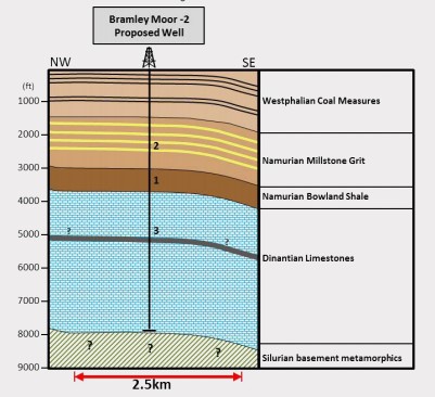
Diagram: INEOS
Proposal
- Construct a well site and new access track
- Mobilise drilling and welfare facilities
- Drill vertical hydrocarbon exploratory core well to 2,400m or 7,900ft
- Mobilise workover rig for listening well operations
- Suspend well for use as a listening well to monitor subsurface impacts of other operations
- Retain site for temporary period of five years
- Restore or submit further planning application for additional work
Purpose of the well: Test geological properties of the underlying strata, particularly Bowland Shale and assess potential to produce gas.
Flow tests and fracking: INEOS said it has no plans to flow test or produce gas by hydraulic fracturing but it said:
“If results show that shale has potential to produce gas and that further development is likely to be acceptable from a planning safety and environmental viewpoint then further assessments may be undertaken to support a separate planning application for further work.”
Proposed total duration of the scheme: 5 years
Location
Nearest villages: Marsh Lane (nearest homes 370m), Eckington 1.7km), Apperknowle (1.6km)
Nearest homes: Ten Acres Farm (300m) and Heatherlee Farm (320m)
Present site use: agricultural land
Landscape: arable farmland
Nearest listed buildings: Ash Lane Farm (500m to south)
Nearest Sites of Special Scientific Interest: Moss Valley (2.3km to northeast), Moss Valley Meadows (2.1km to north), Moss Valley Woods (2.2km to north east)
Landscape protections: North East Derbyshire Greenbelt, Moss Valley Conservation Area (250m to north) and West Handley Conservation Area (700m to south), Special Landscape Area (300m to south)
Nearest water courses: Tributary of River Rother (750m to south west) and tributary of River Moss (850m to northwest)
Petroleum Exploration and Development Licence (PEDL) area: 300
Licence work commitment: Drill one vertical well, drill and frack one horizontal well, carry out 2D and 3D seismic surveying
Proposed stages of work
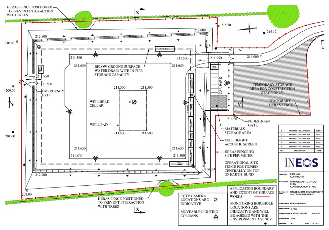
Proposed site plan: INEOS
Stage 1: Site development and establishment
Duration: 3 months
Working hours: Mon-Fri 7am-7pm, Sat 7am-1pm
Staff numbers: 10 plus 2 security
Vehicle movements over 3.5t: 2,162
Operations:
- Surveys and fencing with 2m Heras fencing (which would remain remains throughout the permission) – 2 weeks
- Development of opening onto highway, access track and parking – 3 weeks
- Site clearance and development – 6 weeks
- Removal of top 300mm of soil
- Creation of soil bunds around site edge
- Creation of hardstanding area (25mx17m) at centre of site
- Construction of 2.5m concrete ring for well cellar from which the well will be drilled
- Lining site with geotextile liner
- Perimeter drainage ditches with storage pipe
- Site surfacing: cover liner with 450mm depth of aggregate
- Construction of concrete pad for rig on hardstanding
- Installation of cabins
- Installation of groundwater monitoring boreholes
- Completion of site works and demobilisation- 3 weeks
- Seeding soil bunds with grass seeded geotextile blanker
- Install 1.3m fencing, acoustic screening CCTV, lighting
Stage 2: Drilling, coring and suspension
Duration: 3 months
Working hours: Assembly, drilling, coring, suspension 24-hours a day; site deliveries Mon-Fri 7am-7pm, Saturday 7am-1pm
Staff numbers: 25 plus 3 security
Vehicle movements over 3.5t: 2,448
Operations
- Mobilisation and assembly of drilling rig – 2 weeks
- Delivery of drill rig, drill pipe, water, additives, bottom hole assembly components, logging equipment, mud pumps, casing, cementing equipment
- Drilling and coring – less than 10 weeks
- Drill casings: 7” casing down 1,200m, 6 1/4” casing down to 2,400m
- Rig details: Max height 60m, max length 32m, max width 12m, max weight 350 tonnes, 76 loads (152 movements) to mobilise rig, of which 6 are abnormal loads, overall sound power level 113dB
- Drilling fluids: Water for drilling upper rock layers; Water-based muds when drilling to base of Westphalian Formation coal measures; Low toxicity oil based mud when drilling through deeper strata
- Suspension of well – 2 weeks
- Demobilisation
- Rig and ancillary equipment, waste and most cabins removed.
Stage 3: Maintenance of suspended well site
Duration: Up to 5 years of application
Working hours: Mon-Fri 7am-7pm
Staff numbers: up to 5
Vehicle movements over 3.5t: 40
Operations: visits (ranging from daily to annual) to check on security, operations, environment, drainage, facilities and wellhead
Stage 3a: Possible workover to re-enter well for maintenance
Duration: 1 month
Working hours: Mon-Fri 7am-7pm except in emergencies
Staff numbers: 10 plus 3 security
Vehicle movements over 3.5t: 438
Operations: well maintenance
Rig height: Maximum 32m
Stage 4: Use of well as a listening well
This stage would take place only for baseline monitoring or when another well was fracked
Duration: Up to three weeks as required
Working hours: Mon-Fri 7am-7pm
Staff numbers: 5-10 plus 3 security
Vehicle movements over 3.5t: 496
Operations
- Mobilisation of workover rig (max height 32m), listening truck, welfare, generators, storage – 2-3 days
- Placing geophones inside casing
- Listening operations – up to 15 days
- Demobilisation – 2-3 days
Stage 5: Abandonment (decommissioning) and restoration
Duration: 2 months
Staff numbers: 20 plus 3 security during decommissioning, 5 for restoration
Vehicle movements over 3.5t: 1648
Operations and working hours
- Plugging and abandoning the well – 2 weeks, 24-hours
- Removal of wellsite equipment and surfacing – 2 weeks, Mon-Fri 7am-7pm,
- Restoration of ground – 3 weeks, Mon-Fri 7am-7pm, Sat 7am-1pm
- Aftercare – up to 5 years
Key issues for the application

Bramleymoor Lane. Photo: DrillOrDrop
Traffic
Total movements for all vehicles at all stages: 14,444. This comprises cars: 5484; large goods vehicles (3.5-7.5t): 2,628; HGVs (7.5-32t): 6,332
Maximum movements per day (all vehicles): Stage 1 site construction: 70; Stage 2 drilling, coring, suspension: 60; Stage 3 maintenance: 32; Stage 3a workover: 59; Stage 4 listening well: 55; Stage 5 decommissioning 62
Maximum impact of development traffic: 1% increase on the baseline on the B6056 near the site (planning statement)
Maximum increase in HGVs: 17%
Proposed route to the site: Leave M1 at junction 31, following A57, A630 and A6102 to Norton. The final 6km follows the B6057 Jordanthorpe Parkway and B6056 Eckington Road and Snowden Lane.
Noise and vibration
INEOS said noise from construction may be audible at times but “it is not expected to exceed assessment criteria”.
Noise from drilling and coring activities was expected to be below the 42dB limit at night. Daytime noise levels would be below 55dB. The planning statement said:
“As the noise will be temporary and below the threshold levels, there is not anticipated to be an adverse effect on quality of life.”
The most sensitive areas were likely to be Ten Acre Farm (140m from the site boundary), houses on Bramley Road and Ridge Road in Marsh Lane (370m), Heatherlee Farm (320m) and Ash Lane Farm (500m to south).
Noise levels at the village school would “be very low and are not expected to have significant effects either inside or outside the school premises”, the statement added.
INEOS said the impacts of noise would be reduced the use of bunds, containers and cabins, acoustic screens, silencers and noise attenuation equipment. Adverse impacts from vibration from drilling were expected to be negligible.
Air quality
The application said emissions would include vehicle and equipment exhaust fumes, dust and potentially methane releases but there would be no planned flaring or venting. It concluded:
“Any emissions which do occur will be short-term and very small in volume and are not expected to have a material effect on local air quality.”
Water and flooding
INEOS assessed the site as having a very low risk of flooding and concluded there would be no effect on the water quality of nearby watercourses because there would be no connection between them and the site.
The application said the site was an area with a secondary aquifer but this was not used for public drinking water and there were no abstractions from the aquifer within 1km.
Contamination
INEOS said groundwater pollution would be avoided by the use of modern drilling techniques and “a wide range of controls to avoid pollution incidents”.
The site was described in the planning statement as in “a relatively low risk area of coal mining influence”. A geophysical survey showed the site was not above shallow mine workings, the statement added.
Human health
“It is considered that the risk to human health is negligible”, the application concluded.
Ecology
The planning statement said “there were no known records of protected or notable species within the site boundary” and it described habitats on the site as “low to moderate ecological value”. There would no loss of habitats of local importance and mitigation was not required, it concluded.
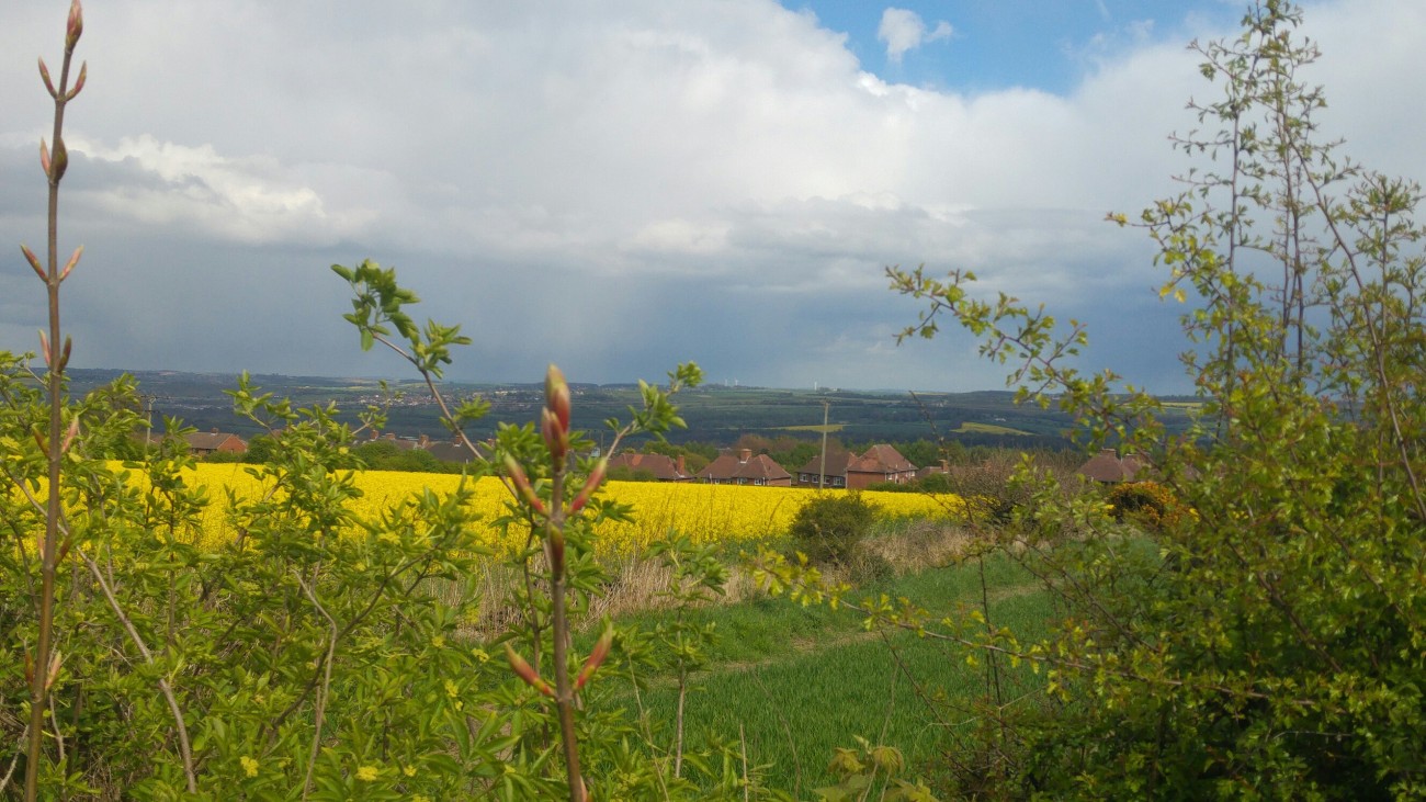
View to Marsh Lane from Bramleymoor Lane. Photo: DrillOrDrop
Landscape
The planning statement said the impacts on the landscape would be moderate at worst. Visual impacts would be moderate or substantial for people living on the western edge of Marsh Lane, at nearby farms and for some in Middle Hanley.
No important landscape features would be lost as a result of the proposal. The most intensive part of the work would last only 21 weeks. Once the drilling rig and main infrastructure were removed, the site would have limited effects on landscape character, the application concluded. The site would not undermine the Special Landscape Area to the south.
Green belt
The planning statement argued that mineral extraction is not inappropriate in the Green Belt, provided it preserved openness and did not conflict with Green Belt purposes. The duration of the activity would be short and it would entirely reversible, the application added.
Heritage
The application concluded:
“Some medium-value listed buildings could experience a short-term change in their setting, (but) there is not considered to be any long term permanent change.
“It is concluded that the development will not result in substantial harm to the historic environment that any small harm to below-ground remains can be adequately mitigated.”
Climate change
The application said:
“The potential contribution of the proposal to national greenhouse gas emissions would be negligible. Climate change emissions associated with the proposal are expected to be limited primarily to those from vehicles and drilling equipment, which are considered to be small and not significant.”
Lighting
The site will be lit at night during 24-hour operations. Most nearby homes would be screened by the landscape or trees and hedges and INEOS said “there is no potential for direct glare impacts at these properties”. The rig would be lit and visible at night. Lighting would be powered by diesel generators.
Cumulative impact
The application said:
“INEOS are not aware of any other major mineral developments occurring either concurrently or successively, that when combined with this proposal, would have an unacceptable cumulative effect.”
Links
Derbyshire County Council webpage for the application
INEOS webpage for Bramleymoor Lane
Eckington Against Fracking Facebook page
Categories: Regulation


Amusing:
Alarming:
http://www.motherjones.com/blue-marble/2012/06/pa-fracking-eviction
Earth Shaking:
http://www.motherjones.com/environment/2013/03/does-fracking-cause-earthquakes-wastewater-dewatering
Great article – and this is realted to UK shale gas how??