 Fracking at Cuadrilla’s shale gas site near Blackpool, which began last week, has already been linked to 12 minor earth tremors.
They were too small to feel at the surface. Some were described as micro-seismic events.
But two, with magnitudes of 0.3 and 0.4, reached the amber level on the traffic light system, the regulation for monitoring earthquakes induced by fracking.
Another of this week’s tremors, at 0.48, was almost at the red level, where operations are supposed to pause.
The activity has prompted an energetic debate about the traffic light system: where did it come from, is it working in the way people expected and what does it mean for Cuadrilla’s Preston New Road site.
Where did the red light come from?
In spring 2011, there were more than 50 earth tremors, near Preese Hall, another shale gas well in the Fylde where Cuadrilla was fracking.
The tremors measured between -2 and 2.3 on the Richter or local magnitude (ML) scale. The largest was felt by people across the area and Cuadrilla suspended operations at Preese Hall.
A year later, in April 2012, a government-commissioned report linked the tremors to Cuadrilla’s fracks. It recommended:
“Seismicity can be mitigated by deploying a real-time seismic monitoring ‘traffic light’ system, to take action when observed seismicity reaches certain levels”.
The report proposed, at least for the next few operations, that the liquid used to frack the well should be flowed back immediately if seismic events with a magnitude of 0.5ML or above were detected – the equivalent of a red light.
This recommendation was developed by the government into the traffic light system, or TLS. It is now being used to regulate activity at Preston New Road, which is the first high volume hydraulic fracture in the UK since the Preese Hall earthquakes. Traffic Light System leaflet

OGA Infographic. Source: gov.uk
Measuring earthquakes
Earthquakes are usually described by their magnitude or size, measured in the UK by the ML scale.
This is a logarithmic scale, where means that each whole number increase in magnitude represents a tenfold increase in the maximum ground displacement.
The Oil and Gas Authority says it uses ML for the traffic light system because it can be computed very quickly. It is a single figure that does not vary depending on depth, distance or surface geology.
But the intensity of a tremor – the effect as it is experienced at the surface – is also important. A large magnitude earthquake at a great depth may do less damage at the surface than a smaller, shallower tremor.
Intensity, referred to as ground motion, depends on factors such as local geology and the frequency of vibration. One way to measure ground motion is by peak particle velocity or PPV. This is recorded at a particular location using a vibration monitoring array.
Cuadrilla showed the PPV effects of some Blackpool activities on its seismic e-portal. It said a passing Blackpool tram generates a PPV of 0.4mm/s. Cuadrilla calculated that this was equivalent to the effect of an earthquake of magnitude 1.8 occurring at a depth of 2.5km.

Ground motion chart on Cuadrilla web portal
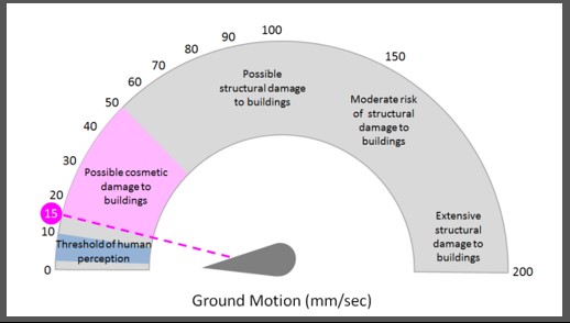
Ground Motion chart. Source: Cuadrilla website
British Standards set a PPV of 15 millimetres per second as a safe level. Above this, buildings may begin to experience cosmetic damage.
Earthquake magnitude and ground motion are both used to regulate seismicity induced by fracking. Both are referred to in Cuadrilla’s hydraulic fracture plan for Preston New Road.
Traffic lights at Preston New Road
The first time a Preston New Road earth tremor reached 0.3ML, there were expectations that Cuadrilla would register this as an amber event and take action required under the TLS.
But the company said this tremor, recorded on 19 October 2018, did not count as amber because fracking was not underway at the time.
According to the hydraulic fracture plan and the TLS, the three stages apply only when liquid is being pumped, during fracking operations.
A flow chart in Cuadrilla’s hydraulic fracture plan (p23) shows how the company expects the TLS to work in practice.

Traffic Light System Flow Chart for Preston New Road Source: Cuadrilla Hydraulic Fracture Plan PNR 1/1Z
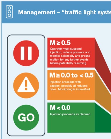
Green light
A seismic event of magnitude less than 0.0 occurs during pumping.
- Operations continue as normal
- Daily reports are submitted to regulators (Oil and Gas Authority, Health & Safety Executive and Environment Agency)
Amber light
A seismic event between 0 and 0.5 occurs during pumping within the operational boundary (a specified geographical area).
- The fracking stage can be completed with caution
- After fracking is completed, pressure within the well is reduced by flowback
- The integrity of the well is checked
- Operations can then continue as normal, maybe at reduced pressure
So far, Cuadrilla has experienced two amber events, on 23 October and 25 October 2018.
Red light
A seismic event of 0.5 or greater occurs within the operational boundary while pumping.
- The fracking stage is aborted
- The well is flushed
- Pressure is reduced
- Further injections are paused for 18 hours
- The integrity of the well is checked
- Ground motion recorded by a vibration monitoring array is compared with forecasts from the ground motion prediction model, which is then updated as necessary
- If ground motion in excess of 15 mm/s is detected, further mitigation steps are taken, such as reducing pressure or moving the injection point
- A report is sent to the regulators together with notice to restart
- Operations can then be re-started
The BGS recorded a 0.5ML tremor on 24 October 2018. But Cuadrilla did not accept this as a red event because it said the BGS had rounded up the magnitude from 0.48 and fracking was not taking place at the time. Since then, the BGS has confirmed it as 0.5ML.
What is a trailing event?
A trailing event is seismic activity which happens when pumping is not taking place.
The tremor on 24 October 2018 would, if Cuadrilla had measured it at 0.5ML, have brought the TLS into play.
According to the hydraulic fracturing plan, Cuadrilla would have to take the following actions if there is a trailing event of 0.5 or higher:
- Well integrity is verified and reports on the event sent to the regulators
- If there is ground motion greater than 15mm/s, mitigating steps are taken
- Operations can then be restarted
Does red mean stop?
The original summary of the TLS, published by DECC in 2014, suggested that a red event really did mean Stop.
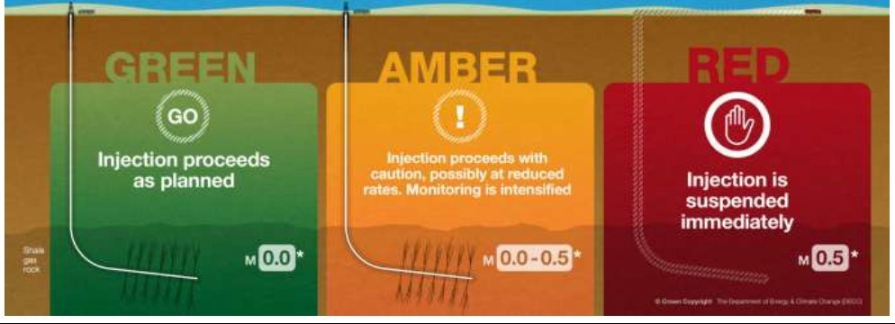
Part of DECC infographic on Traffic Light system (2014). Source: OGA
But a later version of the TLS information leaflet made it clear that a red event would lead to a pause rather than a stop.
Part of OGA infographic on Traffic Light System
So what would stop, rather than pause, fracking?
According to the hydraulic fracture plan, the key to whether fracking continues after a red seismic event is the ground motion, rather than the earthquake magnitude. Any PPV above 15 mm/s risks damage to buildings and could affect buried infrastructure, such as pipelines.
So a seismic event of 2.3 (as happened at Preese Hall) could pause, rather than stop, the fracking process if the surface ground motion was below the 15mm/s threshold and well integrity was intact.
In the hydraulic fracture plan, Cuadrilla has a worst case scenario where a 3.1ML earthquake was the maximum possible that would be induced by fracking at Preston New Road. Even this would only pause, not stop, fracking if the surface ground motion was below the 15mm/s threshold and well integrity was intact.
Seismic events of this magnitude might not cause any surface damage, but could affect the well, as happened at Preese Hall in 2011.
Will the red level change?
The shale industry has indicated previously that it regards the 0.5ML level as too low to trigger a red light. A red event, even with a pause, could cost at least a day’s delay. Cuadrilla told the High Court earlier this month that every day’s delay cost it £94,000.
The OGA said in its document on the TLS that the 0.5ML limit on red events “may be adjusted upward if actual experience shows this can be done without compromising the effectiveness of the controls.”
The energy minister, Claire Perry, told MP Kevin Hollinrake in the summer, that the earthquake rules could be relaxed.
In a letter, she said:
“The TLS [traffic light system] is set at an explicitly cautious level but, as we gain experience in applying these measures, the trigger levels can be adjusted upwards without compromising the effectiveness of the controls.”
But in response to a parliamentary question by Louise Haigh earlier this month, she appeared to backtrack:
“I can absolutely confirm that I am not considering weakening the monitoring controls on seismicity”.
Links
Preese Hall Shale Gas Fracturing – Review & Recommendations for Induced Seismic Mitigation, DECC report April 2012
Shale gas extraction in the UK: a review of hydraulic fracturing Royal Society and Royal Academy of Engineering June 2012
Cuadrilla Environmental Statement
Appendix L – Induced Seismicity Arup June 2014
Seismicity UKOOG 2017
Predicting and Monitoring Ground Motions Induced by Hydraulic Fracturing OGA commissioned paper May 2017
OGA Traffic Light Monitoring Scheme to mitigate induced seismicity OGA July 2017
Managing onshore induced seismicity OGA Infographic 2018
Cuadrilla Hydraulic Fracture Plan PNR 1/1Z Cuadrilla Resources June 2018
In particular, see Section 2.0(d) on page 4 and Appendix 4 (p23)
Cuadrilla ePortal Seismic and other information on Preston New Road 2018
(problems displaying with Microsoft Edge browser)
Categories: Regulation


An excellent post and to my mind a very worrying post. It appears that unless we are pretty much at the level where buildings may be damaged it is a case of carry on fracking. It was very interesting to read Mr Grayson’s comments as I have spoken to other geologists that have said that fracking and the possibility of later impacts is not an exact science. There have been studies in the US that have shown that small seismic events have increased in both magnitude and frequency years later.
It seems the red light means bugger all squared; continue in 18 hours, cause equivalent ‘trailing events’ but they don’t count?
Meanwhile what the hell is happening down there in this faulted region is beyond all of us……it’s like chapter and verse from the ‘Book of Stupid’.
When will the ‘gold standard regulators’ step in I wonder?
Bip………bip………….bip, bip-bip-bip; PING!
Correct Sherwulfe. I always thought the TLS was industry suicide, there wasn’t resistance to signing up to it. But they are clearly smarter than us…..18 hours is perfect when you are not working at night.
Paul, that’s odd, the rigs I have worked on have always been 24-hour operational. “Not working at night” would jack up costs. Robin Grayson Lib Dem Geologist
Robin – Same with me, all over the world including UK onshore Always 24 hours. I think it may only be the hydraulic fracturing and well testing which is restricted to day time. Perhaps someone can confirm this (or not)?
The whole thing is a farce Paul; it would be ‘irrelevant’ to create major events as it was not ‘at the time’……but clearly as a result of……..and just who is saying what; would love to see Cuadrilla’s script…I wonder how much of the narrative would suddenly go missing?
Still, the good news is the media are building up the crescendo ready for the final Aria…..
One consolation, the events have provided a lovely map to present to prospective buyers in the area via local searches……
Yes, Mr. Grayson’s comments were interesting! What is a Liberal Democrat Geologist?
Perhaps someone to advise students how to dig themselves out from a mountain of debt? Via Facebook, of course.
Putting on my logic hat, I suspect we may see two traffic light scales. First, to cover initial wells at much the same as current levels, to prove that all is okay for that particular site and then perhaps a somewhat less restrictive scale for when that has been conducted. That would take account of the individual geology for sites and also accommodate the fact that most sites will see multiple wells drilled and fracked.
Looking at the facts from Preese Hall it appears that you need to create unacceptably high seismicity to get poor gas flow.
Excellent business model ,not.
Preese Hall was a vertical well apparently John? Horizontal in a sandy section may prove different? And now it appears from this article that it will take a lot to shut this down.
I thought Preese Hall was vertical? If so, not same model.
There is a joke in there about vertical v horizontal that would fit-but much more fun to make up the tag line yourselves.
about 4 a day at the moment, last one was 0.8 3 hours ago , these have been increasing in intensity since they started. so tell me again how pumping polluted liquid back 2km to the surface up a pipe a few inches thick through an unstable geo structure isn’t likely to cause problems. even if the stucture of the ground is safe , constant drilling is causing it to become unstable …
Hi folks, while blow-outs are rare, when they happen they can have very severe consequences. Therefore all onshore and offshore rigs should have detailed emergency procedures, and for onshore rigs this should include a dossier on emergency procedures produced by the driller and shared with the local community and the local emergency services such as fire, police, ambulance, hospitals and army. Cuadrilla has not published any such document, and until it does and the document is approved, then drilling must be suspended. Here is a link to videos on accidents at wells due to failure of blow out preventers due to many causes, including equipment failure and human error. It would be prudent for everyone concerned about fracking on Preston New Road to examine this link, especially Cuadrilla’s investors, management team, geologists and not least the police, protestors, local residents, farmers, walkers and anyone using the main road. Robin Grayson MSc Lib Dem Geologist
https://www.bing.com/videos/search?q=well blow out preventer accidents&qs=n&form=QBVR&sp=-1&pq=well blow out preventer accidents&sc=0-33&sk=&cvid=55297EB96230472BB608B73CCC3F3DF9
[Moderator] Try this link: https://www.bing.com/videos/search?q=well%20blow%20out%20preventer%20accidents&qs=n&form=QBVR&sp=-1&pq=well%20blow%20out%20preventer%20accidents&sc=0-33&sk=&cvid=55297EB96230472BB608B73CCC3F3DF9 [/moderator]
What a shabby effort at fearmongering Robin and frankly it should be beneath a former industry professional. You say blow-outs are rare, but you dont say just how rare, other than post a link to a load of scary looking pictures. Theyre rare in the world as a whole these days, and even more so in the UK and Europe. Maybe you’d like to post some pictures of one from the UK in the past 20 years ?
The wellhead at PNR is a full 150m or so from the main road, no doubt planned that way for exactly this reason. Nobody says theres zero risk, but with with calls for even the army to be informed, your post above is just stirring the fears of people who are less familiar with the risks than you and the regulators are. This might be expected from some of the people who have never even seen a rig, let alone stepped on a drillfloor, but its very poor from someone who should know better.
I hear you loud and clear Martin.
It would of course be much better if Cuadrilla explained to you and everyone else why they have consistently failed to publish an Emergency Plan and failed to organise any training of the police, fire services, ambulance crews, army, hospital staff and local residents etc in “what to do” if there is a blow-out at their well or how to plan for such an eventuality.
Martin, you are right to be unsettled by the videos of blow-outs, and so am I.
But the videos are in the public domain and the Lancashire public have a right to see what a blow-out might be like, and only then might frackers and their regulators be pushed to take urgent action to address legitimate safety concerns. Which means Cuadrilla produce and circulate a credible Emergency Plan, which they have consistently neglected to do.
“There are no public details of Cuadrilla’s Emergency Plan or the Lancashire LRF risk assessment for Preston New Road.”
https://drillordrop.com/2018/08/28/interview-planning-for-emergencies-and-accidents-at-oil-and-gas-sites/
Martin, here in black and white is why Cuadrilla’s Emergency Plan must be published.
I would be interested to know what your opinion is on this. Robin Grayson MSc Lib Dem Geologist
WEEKS AFTER TEXAS OIL WELL EXPLOSION, FAMILIES STILL GO HOME
https://insideclimatenews.org/news/09062015/weeks-after-texas-oil-well-explosion-families-still-cant-go-home
Three weeks after well explosion, families are still waiting and worrying as Canadian oil company Encana decontaminates their homes in Karnes County. By Lisa Song, InsideClimate News Jun 9, 2015
An oil and gas well pad site in Karnes County, Texas, in the Eagle Ford Shale on June 1, 2015, a week and a half after a well blew out, spewing a mixture of crude oil, condensate and natural gas into the air. More than a dozen households were evacuated. Five families are unable to return home because their houses are being decontaminated.
Several families remain displaced three weeks after an oil well exploded in Karnes County, Texas, and the true extent of the contamination is unknown. More than a dozen households were evacuated after the well blowout in mid-May. As of Monday, five families were unable to return home because their houses are being decontaminated, said Doug Hock, a spokesman for Encana, the Canadian company that owns the well.
Three of the families are at a local hotel. Leonard Cordova, his wife and their 2-year-old daughter have shared a hotel room since May 19. Their three indoor cats are staying with them. The family’s dogs are at a friend’s house, and their three outdoor cats are still living on the Cordovas’ property, which is across the street from the well that blew.
“As far as I know, our [home] is one of the hardest ones hit,” Cordova said.
“They’re not allowing us to go back to our property,” he added. “They have guards out front, and if we try to go back, they call the police.”
Cordova said he wants to go back to retrieve important documents like birth certificates. Encana has offered to do it for him, but Cordova said he’s uncomfortable with the idea of strangers going through his personal belongings.
“We left with nothing,” he said. “We left with the clothes we had on. All my daughter had was a shirt and a diaper.”
Encana provides the three families with food every day, as well as per diem, Cordova said.
Hock, the Encana spokesman, said the remaining two families whose homes are being cleaned are vacationers or absentee landowners.
One is retired Vietnam veteran Lucas Jasso, who lives part-time in Corpus Christi. Jasso said he spends most of his time in Karnes County, and is devastated by the damage to his land, where he raises three cows and two bulls. Jasso hasn’t stepped foot into his house since the explosion, but he made two brief trips to his property while accompanied by an Encana representative.
“I felt like crying seeing the mess spewed by the well,” he wrote in an email. “My [cattle’s] grass was yellow, leaves off my trees were falling and on the ground.”
Jasso said his cattle have been relocated. He also received $2,000 from Encana, and a neighbor told him each of the evacuated families had received the same. “I really don’t know what to make of all this,” Jasso said. “It’s not so much that I’m concerned…[but] I don’t see a light at the end of the tunnel for the inconvenience.”
Cordova said he asked Encana to help his family find temporary housing, but he expects it will be hard to relocate since the oil boom has created a housing crunch. The family needs to stay nearby, he said, because his wife works in Karnes City. “We just need a place to stay that’s not a hotel,” Cordova said. “We need a yard, and a home where my daughter can play…She doesn’t really have anything to do all day” at the hotel.
Cordova and Jasso were frustrated with the oil industry long before the explosion put them out of their homes. They say their lives have been turned upside down with noise, traffic and environmental concerns. Karnes County is at the heart of the South Texas Eagle Ford Shale, one of the most active oil and gas fields in the country. Since 2008, more than 12,000 wells have been drilled in the region.
“Personally I never really liked” the industry, said Cordova, who worked for an oil and gas contractor before getting laid off when oil prices tanked. “Before all this stuff happened, it was nice and quiet…Now it’s just nonstop traffic, 18-wheelers, loud and polluted. It’s not what it was.”
The Encana well was located near the intersection of Farm to Market Road 792 and County Road 343, a few miles outside Karnes City. When it exploded, it sprayed a mix of crude oil, natural gas and condensate (light petroleum products used for petrochemicals and manufacturing) that turned the grass brown.
Hock said Encana is in the midst of an “environmental sampling program,” and is consulting an ecologist on cleanup methods. “We will have a better idea of the size of the clean-up area next week when the environmental assessment is complete,” he said in an email.
Encana also brought in veterinarians to examine affected livestock, Hock said. Some of the livestock had to be washed and cleaned, but he said there were no long-term impacts.
“Hopefully they’ll return the land to a pristine stage,” Jasso said, though he worries he’ll have reservations about lasting impacts no matter how clean it looks.
Still, Jasso has no intention of selling his property or moving away. “It’s my paradise,” he said. “They ruined it.”
Cordova said he and his wife are debating whether they want to stay. The house has been in his wife’s family for generations, he said, so she has an emotional attachment to their home. But Cordova worries about the health impacts on his daughter, even after the cleanup is complete. His own health has deteriorated since the explosion. Cordova said he’s taking Ibuprofen for persistent headaches and has coughed up white mucus every morning and night for nearly two weeks.
Hock said it would be premature to discuss whether Encana would consider buyouts for families that might want to leave. “Our focus is on cleaning the environment and people’s homes so they can safely return,” he said.
Jasso and Cordova said the explosion has left them unsure of what to do next, and they don’t know what they’re entitled to receive from Encana. Jasso said he called a lawyer for help, but didn’t know what questions to ask. “We know nothing,” Cordova said. “We’re just kind of left in the dark, playing the waiting game.”
I seem to remember other geologists indicating nothing was likely to emerge from PNR in terms of gas?
Doesn’t seem a very exact “science” does it.
Who provides Cuadrilla’s public liability insurance? It has to be in there surely – the Royal Society report mentioned the importance of insurance..as part of ‘gold standard regulations’.. Its very easy for the MSM/general public to understand – and recognise the need for. It’s not possible for anyone insured to raise or alter predefined limits without an OK from their insurers,. anyone with car or house insurance understands that.. so is it worth looking at who is really ‘covering’ the risk?
Good question!
Have a look at what the UK insurance industry have to say about the insurance risk of fracking in the UK:
https://www.cii.co.uk/knowledge/claims/articles/the-insurance-implicatios-of-fracking/45177
Go there and download the PDF. It is out of date but illuminating. Robin Grayson Lib Dem Geologist
No insurance; no mortgage. Cash sales only, if you are willing to live in another Groningen……..only a matter of time.
bip……………bip………………..bip, bip; ping!
Another Groningen sized field would be great for the UK. Subsidence is the issue at Groningen.
Caused by gas extraction, yes I know it’s another medium, but earthquakes – started small, over time, houses literally propped up! shocking….
Another Groningen sized gas field would be a disaster for the planet and you know it.
Comments on Groningham Gasfield are out of place here.
It is a Superfield of huge size, and completely different from Preston New Road.
The reservoir rock of the Groningham Gasfield is very porous and produces lots of methane from its pores.
The reservoir rock is equivalent to the Collyhurst Sandstone named after its lost exposures in Manchester.
The Collyhurst Sandstone consists, like the Dutch Groningham reservoir rocks, mostly of wind-blown dune sand and that is why it is so porous. Check here for the BGS formal naming of the Collyhurst Sandstone: http://www.bgs.ac.uk/lexicon/lexicon.cfm?pub=CS.
Relevant though, the Groningham=Collyhurst=Elswick, a tiny gasfield in the Fylde, discovered by conventional wildcat drilling by British Gas in 1990. The drill did wander off slightly from being absolutely vertical. Of interest is that the Elswick Gasfield license was later sold to Cuadrilla Elswick. According to Cuadrilla’s website: https://cuadrillaresources.com/site/elswick/
“The site in Elswick is currently Cuadrilla’s only production well site and the vertical well was hydraulically fractured in the underlying natural gas bearing sandstone formation in 1993.”
“The natural gas produced from the well at Elswick has been used to generate 1MW of electricity on site continuously during its early life. Gas extracted from the sandstone formation was sent to a small onsite generator, and electricity generated fed into the electric grid via underground cables. Natural gas rates have been declining over the producing life and the well has now approached the end of its producing life.” “Located off the main road into Elswick, the site is visually unobtrusive, with many people in the area unaware of its existence.”
Although Elswick Well #1 produces gas from probable Collyhurst=Groningham sandstones, the dream of ever finding a Groningham-sized gasfield onshore in NW England are long gone, although the Manchester-Warrington-Stockport-Knutsford area, and the Formby area, remain prospective for profitable – but small – conventional gasfields in the Collyhurst Sandstone. Of critical importance is, of course, the presence of a good seal, and the overlying Manchester Marl and Eccles Mudstone are ideal for this – if present. Click here to read up on this:
https://www.researchgate.net/publication/320567816_FYLDE_BRIEFING_NOTE_1_-_The_Manchester_Marl_seal_and_the_freshwater_Eccles_Mudstone
Examples of other useful articles include:
Click to access p1549.pdf
Hannis, S, and Gent, C. 2017. Petrophysical interpretation of selected wells near Liverpool for the UK Geoenergy Observatories project. British Geological Survey Internal Report, OR/17/037. http://earthwise.bgs.ac.uk/index.php/OR/17/037_Discussion
https://www.sciencedirect.com/science/article/pii/S0037073818301118
Robin Grayson MSc Liberal Democrat Geologist
Thanks Robin – hopefully Sherwulfe will understand you. Groningen is irrelevat to Bowland shale. No subsidence when producing shale gas…..
No Robin; the analogy is the ignorance and build up over time resulting in destruction of property, not about the medium. Its starts small, then builds up and before you know it you are in an induced earthquake zone….good for property values and insurance; tell that to your constituents…
https://dwarshuis.com/earthquakes-groningen-gas-field/visualisation/
‘ No subsidence when producing shale gas…..’ aaah, the ‘Egan’ effect…
Sherwulfe – Subsidence in Groningen gas is entirely irrelevant to fracking Bowland Shale in the Bowland Basin. No geologists that I know, and I know a lot, would accept your opinion. Robin Grayson Lib Dem Geologist
Dear Robin; think past the geology and think cumulative impact of seismicity…..it’s not an opinion, its an observation. You must understand, this is not a challenge to you and your geologist mates, but a warning of the effect of shoving it under the carpet, downplaying and even lying about this side of the fracking process……
Sherwulfe – Subsidence in the UK is due to numerous causes, notably due to dissolving of beds of rock salt, dissolving of beds of gypsum and other soluble minerals, shrinkage of soils, shrinkage of peat due to drying out, compaction of peat, dewatering of wet sands, behaviour of thixotropic sands, running sands, oxidation of peat to greenhouse gases, underground fires of peat and other combustables, compaction of refuse tips, and of course collapse of abandoned underground mine cavities left after extraction of not only coal, but also for ganister (eg Upholland), fireclay (eg Upholland), brick shale eg (Wigan), limestone (eg Derbyshire), slate (eg Snowdonia), gold (eg Wales), lead (eg Askrigg), zinc (eg Flintshire), copper (eg Llandudno and Parys Mountain), tin (St Ives), graphite (Lake District); for instance by collapse of mine shafts (e.g Wigan), controlled subsidence by total extraction of coal (e.g Monton) etc, collapse of pillars in pillar-and-stall mines of all types, upward migrating cavities by collapse of mine roofs, likewise collapse of rail tunnels (eg airports in London), sewer tunnels (eg Manchester), underground canals (eg Worsley), underground sough mine drainage systems (eg Haigh Hall), underground stream diversions (Manchester).
Regarding fracking, ground subsidence of significance is possible IF fracking disturbs or creates geological faults of sufficient size and of certain shapes, to trigger creation of grabens or half-grabens, or roll-overs or pop-ups that affect the ground surface by downwarping or down-faulting. This is why seismic due to fracking needs BGS monitoring, better geophysical surveys etc.
While the fracking itself is incapable of creating surface subsidence directly, it can do so indirectly if substantial faults are created or reactivated, or if a salt bed is disturbed.
Robin Grayson Lib Dem Geologist
Again, see comment above
Sherwulfe; watcher of ever increasing magnitude seismic events in the PNR area.