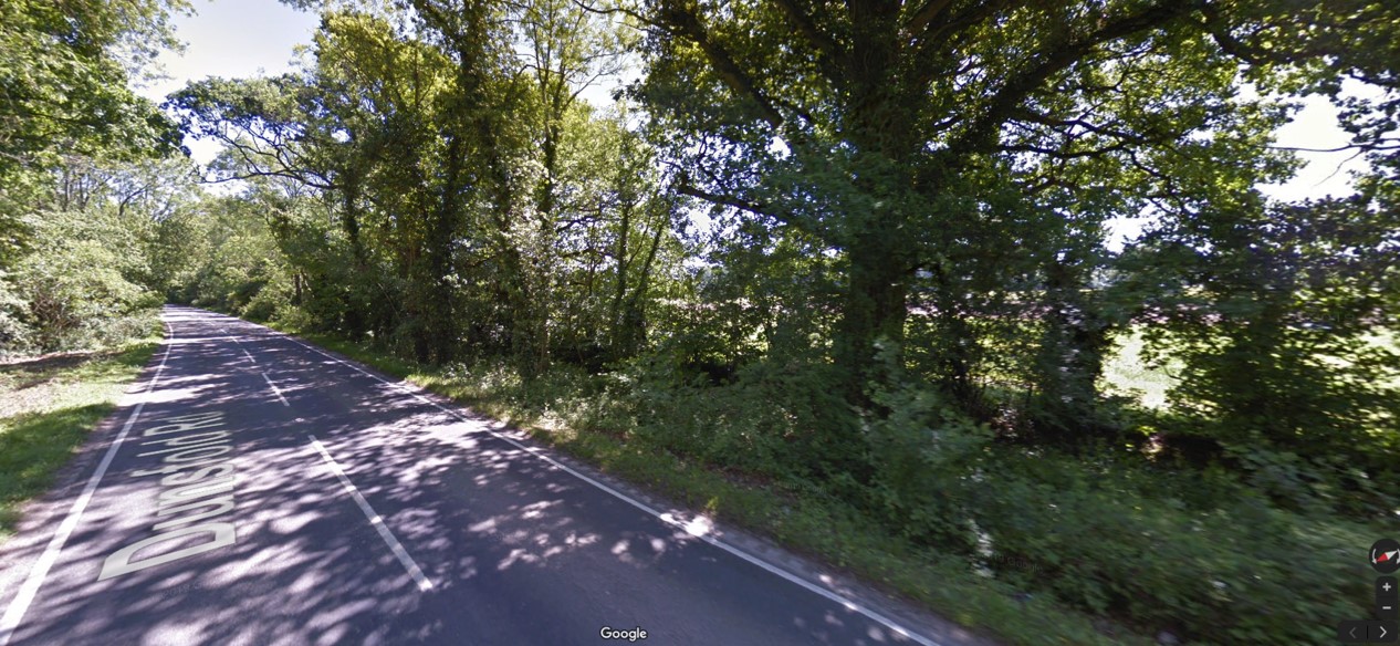
Common land at Dunsfold Road. Photo: Google Maps/Google Earth
The company behind plans to drill for oil and gas near the Surrey village of Dunsfold has applied for permission to build a road junction on common land.

Notice of application for work on Dunsfold Common
A notice in Dunsfold confirmed that a subsidiary of UK Oil & Gas plc had submitted an application to the Environment Secretary.
The application, under the Commons Act 2006, will be decided by a planning inspector.
It seeks permission for work on the verges on the southern side of Dunsfold Road:
- Construction and use of the junction of the site access track and Dunsfold Road
- Creation of sight visibility splays on both sides of the junction
- Installation of removable bollards on an area covering 403 square metres
People are invited to comment on the application until 23 August 2019 (see Commenting on the application below)
The junction is part of an alternative planning application submitted by UKOG last month. The original application took the proposed access track off High Loxley Road.

Map of new proposed access route to UKOG’s oil and gas site. Source: planning application
The issue of ownership of the verges on Dunsfold Road was raised by residents during a meeting organised by Waverley Borough Council last month.
So far this year (2019), there have been 36 decisions about work on common land in England.
Of these, 33 (92%) were granted and 3 (8%) refused.
Among the applications that were refused was one for an area of tarmac next to an existing McDonalds restaurant on Petridgewood Common, also in Surrey.
The planning inspector in this case said:
“the works proposed are in the interests of a private business. I have not identified any benefit to the public interest arising from the works which outweighs the harm to the interests of users of the common.”
The other refusals were to enclose common land. In both cases, the inspectors said the benefits of the fencing did not outweigh the effects on the rights of public access.
Commenting on the application
The UKOG application and documents are available to view until 23 August 2019 at:
- Cranleigh Library, High Street, Cranleigh, Surrey GU6 8AE
- Waverley Borough Council, The Burys, Godalming, Surrey GU7 1HR
Copies can also be obtained from UKOG’s consultants, The Zetland Group Limited, The Innovation Centre, Vienna Court, Kirkleatham Business Park, Redcar TS10 5SH
Representations should be sent to the Planning Inspectorate Commons Team, 3F Temple Quay House, Temple Quay, Bristol BS1 6PN by 23 August 2019
Categories: Regulation


Shock, horror! How dare they apply? It’s outrageous as claiming that obstruction is the same as protesting!
I see UKOG want to build a road junction on common land. What is common land and who owns it?
Time to do some investigation of the rights and ownership to this common land isnt it.
See below from GOV.UK
Common land and village greens
There are rules on how you can use common land and town and village greens.
Common land
Common land is owned, for example by a local council, privately or by the National Trust.
You usually have the right to roam on it. This means you can use it for certain activities like walking and climbing.
Some common land has different rights, so you may be able to use it for other activities, for example horse-riding.
You cannot:
camp on common land without the owner’s permission
light a fire or have a barbecue
hold a festival or other event without permission
drive across it without permission unless you have the right to access your property
Town and village greens
You can use town and village greens for sports and recreation, for example playing football or walking your dog. Some also have ‘rights of common’ over them – like grazing livestock.
The right to roam does not apply.
Many greens are owned and maintained by local parish or community councils. Some are privately owned.
Common land and village greens near you
Find out where your local common land or village green is by contacting your local council. It keeps the ‘Register of Common Land and Village Greens’ for your area.
Each entry in the register includes:
a description of the land
who has rights to use it, and what those rights are
who owns it, or who owned it when it was first registered
Have your say on changes to common land
Planned changes to common land will be advertised in local newspapers and put on signs around the land. If you want to comment on the application, write to:
The Commons Team
The Planning Inspectorate
Room 3A Eagle Wing
Temple Quay House
2 The Square
Temple Quay
Bristol
BS1 6PN
commonlandcasework@planninginspectorate.gov.uk
Telephone: 0303 444 5408
Find out about call charges
If you own common land
The management of common land must take into account the interests of both the owner and the ‘commoners’ (people who have rights over the land but do not own it). This can be done:
by the landowner
informally, by landowners and those with rights on the land working together, for example to keep the land maintained and not over- or under-grazed
formally, by setting up a statutory commons council – the stakeholders sit on the council and make decisions by voting; the decisions of the council are legally binding
Natural England has guidance on managing common land.
Cross compliance and common land
As a landowner, if you claim agricultural payments under the Single Payment Scheme, you must comply with cross compliance rules across all of your agricultural land – not just the land that you claim payments for.
The responsibility for cross compliance with common land is shared with the other stakeholders. If the other stakeholders are actively using the land, setting up a commons council can help with meeting cross compliance rules.
For all those who wish to establish the rights and exclusions for this common land you can contact the links provided.
‘Common land
Common land is owned, for example by a local council, privately or by the National Trust.
You usually have the right to roam on it. This means you can use it for certain activities like walking and climbing’.
Phil C this does not include ‘Slow Walking and Lorry Climbing’!!
It does not include for a private road junction.
Or a private right of access.
Or the right to drive across it without permission unless you have the right to access your property.
That can’t exclude the public right to roam, because it is common land.
The right to roam slow or fast or just stand still is inclusive.
Another storm brewing it seems…..
More from David Kesteven of Fracking Farmhouse.
The Department for Environment Food and Rural Affairs (DEFRA) has an online survey asking for your views on measures to reduce personal water use. Watch David’s video then have your say.
https://consult.defra.gov.uk/water/measures-to-reduce-personal-water-use/
Closing Date: 11th Oct 2019
Read the document and answer to them that in order to save our precious drinking water, that fracking as represented by Cuadrilla’s own predictions at Preston new Road, will use 5.9 to 8.8 million gallons (fracking is American technology, hence the imperial measurements) of fresh drinking water per frack, in four wells, so as David suggests assume an average of 7.5 million gallons per frack. In metric the average would be around 30 million litres of fresh drinking water per frack, and as David says that at 141 litres, which DEFRA are suggesting to be personal water consumption per day, that will be 582 years one persons personal use equivilent to one frack and there may well be many fracks on well.
May i suggest we all answer this DEFRA document and tell them to stop fracking, and then their request for information and opinion can be at least pointing at the right target, fracking at Cuadrilla Preston New Road and all the others waiting furtively in the wings.
And just to remind you there is also the quesionaire on nitrogen lift: closing date 13th August.
https://www.youtube.com/redirect?event=video_description&v=6Uh8JjFJU3M&redir_token=R4YTJUQxEJBBhBwhn3jfSvWhTHN8MTU2NDc3OTM1NEAxNTY0NjkyOTU0&q=https%3A%2F%2Fconsult.environment-agency.gov.uk%2Fonshore-oil-and-gas%2Finformation-on-cuadrillas-preston-new-road-site%2F
And the report on the Pennsylvania fracking report which says 1,778 scientific studies saying that “There is no evidence that fracking can take place without threatening human health”
https://www.youtube.com/redirect?v=jtOZhGABBxQ&event=video_description&redir_token=JM6mhoiF4Zx6nMVdPuNM5bXJddN8MTU2NDc3OTI1NEAxNTY0NjkyODU0&q=https%3A%2F%2Fconcernedhealthny.org%2F
Enjoy!
Enjoy!
Cue, or perhaps more accurately “queue”, hewes and PT……Have A Nice Day……
Phil C
Always up for a challenge.
Good that water use is raised. I expect fracking to get their water other than from the UK potable water supply, should fracking take off. At present it has not.
There is a history of industry creating water storage, be it for canals, mines, cotton mills, the steel industry or In the expectation of industrial use, Kielder Water.
I am sure DEFRA will appreciate the advice that in order to save water now, we should not do something we are not doing ( to any great extent ).
Maybe Boris will resurrect his contour canal idea.
Phil C
You mention the questionnaire re nitrogen lift ( or a request for comments )
Good reminder, and one can see how David K was bamboozled by the EA perhaps
The variation request does not mention N2 lift ( 4th para ).
Click to access Application%20for%20Permit%20VariationFebruary%202019.pdf
The permit variation does not mention it ( as a variation )
Click to access ab3101mw-v005-variation-notice—final.pdf
The info doc dated 20 Feb does not mention it
Click to access Application%20for%20Permit%20VariationFebruary%202019.pdf
But the latest one does dated 16 July
Click to access Application%20for%20Permit%20VariationFebruary%202019.pdf
However, as none of the other docs say that Cuadrilla has asked for consent to use gas lift ( being the more legal ones ), one may wonder why the EA have said that ( as they should only repeat what the permit variation states?
The key issue is, how will they comply with the new permit conditions re flaring given their existing kit and the new flaring requirements?
I would note that most comments submitted just say they do not agree with fracking. Only a few address the specific variations in the permit.
I suspect those that do not address the variations go into the B1N file, once logged, as the consultation is about the variation to the permit, not how you feel about fracking in general?
I referred past to an interesting comment which critiqued how the flaring would work, worth reading.
Phil C
Wind watch cite over 400 studies that say there is no evidence that wind turbines can be built onshore without threatening human health.
So a read of all would seem appropriate, although some may say that the benefit outweighs the risk
https://m.wind-watch.org/documents/category/impacts/health/?titles=on
Perhaps the local Ramblers can help on this one – they could check on footpaths in the area and may also be actively attempting to reinstate a footpath under the Lost Paths Project.
The OSS – Open Spaces Society do a lot of work protecting Common Land. Perhaps speak to them?
I think the main issues here are damage to the flora and fauna as well as safety. If the entrance to the site is gated at this junction, those gates are locked, so have have to wait on that road to get in, which makes it then hazardous to the other road users. Plus the surface of the road will be damaged over a very short period of time, verges will be damaged. Some of the loads are hazardous, so if there are accidents then they need extra emergency services. Also the road continues in both directions leading to dangerous bends for hgvs. UKOG have a history of choosing sites that have caused problems. At Broadford Bridge damage to a railway crossing and at Leith Hill they never did resolve their traffic management plan during the application stage