A gas company has revealed plans to drill an exploration well and carry out a small-scale frack on farmland on the edge of the North York Moors national park.

Initial details of the scheme, on the North Yorkshire and Cleveland Heritage Coast near Scarborough, were sent to the new North Yorkshire Council last week.
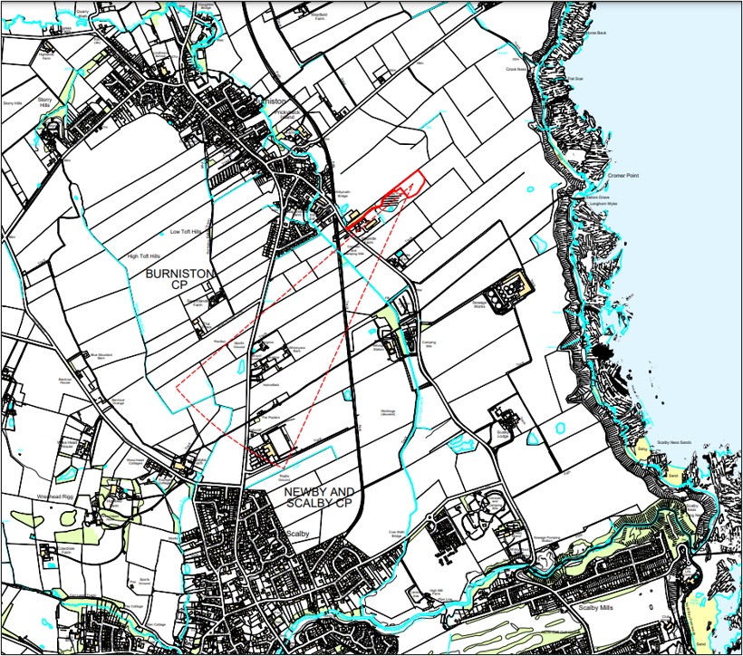
Documents now on the council’s planning website show the operator, Europa Oil & Gas Limited, wants to drill a 1.7km lateral well near Burniston and inject fluid and proppant, such as sand, into the surrounding rocks.
The injection operation, known as a proppant squeeze, aims to improve the flow of hydrocarbons. Regulators regard it as a form of low-volume fracking because the injection pressure is high enough to fracture rocks.
It is not banned by the moratorium on fracking in England because the volume of liquid injected into the rocks is below the limit set by law.
But a proppant squeeze does need consent from the Environment Agency and the North Sea Transition Authority. The operator must set out what it would do to minimise the risk of earth tremors from fracking and how the hydraulic fracturing process would be monitored.
Egdon Resources, a partner in the Burniston proposals, carried out a proppant squeeze at its oil production site at Wressle in North Lincolnshire in 2021.
Request
Details of the plans were revealed in a formal request for a ruling by the council on whether any future planning application needs a detailed report, known as an environmental impact assessment (EIA).
Egdon Resources, writing on behalf of Europa, said an EIA was unnecessary because the proposals were not likely to have “significant environmental impacts”. Operations would take place over “a relatively short time”, estimated at 37 weeks, Egdon said.
The company argued that the plans did not meet the EIA criteria of a site above 10ha and production of more than 100,000 tonnes per year.
It also said the site was not in a sensitive area, despite being on the heritage coast. It said there were a number of “modest socio-economic benefits”, such as local job creation, business rates and the use of local suppliers and businesses.
Egdon said:
“the proposed development is not expected to use significant amounts of natural resources, such as land, soil or fresh water, nor is it expected to produce significant amounts of waste, pollution or nuisances.”
The company also said the scheme was
“not expected … [to] result in a significant risk of major accidents and/or disasters, or to human health”.
It added that “dust, noise, impacts on ecology and pollution of land or water could be avoided completely or reduced to non-significant levels through the implementation of standard mitigation and best practice measures”.
Council planners must now decide whether there should be an EIA and, if so, what it should include.
A landmark judgement by the Supreme Court last month decided that EIAs for onshore fossil fuel developments should consider the climate impacts of burning any produced oil, gas or coal, known as downstream emissions,
Reaction
Steve Mason, North Yorkshire councillor and campaign director of Frack Free United, said today:
“We will be keeping a watchful eye on this application.
“The proppant squeeze technique could also be described as fracking, though not as defined in the Infrastructure Act which the ‘ban’ is based on. It’s a loophole that should be closed.
“The recent court case requiring downstream emissions will have to be factored in. The council should be asking for an Environmental Impact Assessment (EIA) to take into account the emissions produced from the fossil fuels used from this site.
“This application may only be for assessment and the company claims this will not need an EIA, but it’s obvious that the intention will be to maximise the production, otherwise why would they bother?
“Hopefully the new government will act accordingly and stick to its pledges. We are in a climate crisis. We do not need new fossil fuels. When will this sink in?
“If North Yorkshire Council is serious about its route map to being carbon negative, then this application should be opposed, let’s see how serious the new authority is.”
Details

Site area: 1.2ha
Address: Farmland east of The Mill Yard, Burniston Mill, coastal road, Burniston, Scarborough YO13 0DB
Location: Farmland next to a solar array, south east of Burniston village, north of light industrial and storage facilities
Onshore oil and gas licence area: PEDL343 operated by Europa Oil & Gas Ltd, which holds 40% of the licence, in partnership with two companies in the Heyco Energy Group (Egdon Resources, 40%, and Petrichor Energy UK Limited, 20%)
Nearest home: Wayside Farm 320m away
International nature designations within 1km: None.
Other designations: Within North Yorkshire and Cleveland Heritage Coast, North York Moors National Park and coastal SSSI 800m away, Scarborough to Whisby disused railway site of importance for nature conservation 360m away.
Nearest footpath: 400m to west and the long-distance path, the Cleveland Way, is 730m to north east
Proposed access: Existing access road, off coastal road, which serves industrial and storage units
Surrounding landscape: Good to moderate agricultural land – grade 3 (where grades 1-3 are the best and most versatile land), partly screened by woodland, animal feed mill 200m to south east
Flood risk: Egdon said there was a low risk of surface water flooding and the site was not in a drinking water safeguard zone, drinking water protected area, source protection zone or nitrate vulnerable zone
Proposed work plans
Phase 1 site construction
Work: Stripping of top soil, security fencing and gates, installation of containment berm and high density polyethylene membrane overlain by stone
Duration: 7 weeks, including 2 days for site mobilisation and 2 days for demobilisation
Traffic: 330 HGVs, average of 7 per day with a maximum of 17 on any one day
Hours: 7am-7pm Monday-Friday, 7am-1pm Saturday
Phase 2 drilling
Work: Lateral borehole drilled for about 1.77km from site to south west, between Burniston and Scalby, using 30m rig
Other equipment: toolpusher cabin, toolhouse, generators, fuel tanks, matting boards, blow out preventers, manifold, six security and welfare cabins, 10 car parking spaces
Duration: 7 weeks, including one week for rig mobilisation, five weeks for drilling and completion and one week for demobilisation
Traffic: 330 HGVs, average of 7 per day and maximum of 18 on any day
Hours: Mobilisation and demobilisation 7am-7pm Monday-Friday, 7am-1pm Saturday. Drilling and completion of borehole: 24 hours, seven days a week
Phase 3 proppant squeeze and flow testing
Work: Small scale hydraulic fracture, which requires hydraulic fracturing consent from Environment Agency and North Sea Transition Authority
Duration: 17 weeks, comprising 1 week of initial testing, 1 week of proppant squeeze, 15 weeks of flow testing
Traffic: 40 HGVs with an average of 1 per day and maximum of 5 per day
Hours: 24 hours, 7 days a week
Phase 4 well decommissioning, site restoration and after care
Work: restoration to agricultural use. Plugging and abandoning wells, casting strings cut at least 2m below ground level and metal plate welded across the casing, replacement of top soil
Duration: 6 weeks to restore the site
Traffic: 350 HGVs, with an average of 8 per day and a maximum of 17 per day
Hours: 7am-7pm Monday-Friday, 7am-1pm Saturday
jobs that don’t cost the earth.”
DrillOrDrop has closed the comments section on this and future articles. We are doing this because of the risk of liability for copyright infringement in comments. We still want to hear about your reaction to DrillOrDrop articles. You can contact us by clicking here.
Categories: Regulation, slider

