Image: UKOOG
A long-awaited visualisation of what shale gas production could mean for the UK countryside has been released by the fracking industry.
The Thirsk and Malton MP Kevin Hollinrake, who asked for the visualisation at a meeting with the industry in February last year, said it could build confidence among residents in shale areas.
But opponents of fracking, who have been waiting for the release for more than 11 months, dismissed it as misleading and unhelpful.

Image: UKOOG
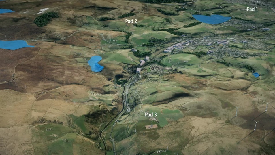
The work, commissioned by the industry body, UK Onshore Oil and Gas, is a 5-minute 3D video of two petroleum exploration and development licences, said to be typical of shale gas areas. It is accompanied by a report “Developing Shale Gas and Maintaining the Beauty of the British Countryside“.
The visualisation shows three well pads in each 10km by 10km licence. The report, however, predicts 7-11 pads in a 10km by 10km licence. Both the visualisation and the report suggest there would be about 10 wells on each pad.
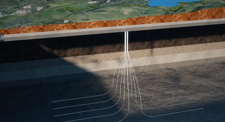
Image: UKOOG
UKOOG said the video demonstrated the low impact of potential shale development in the UK. It compared drilling rigs favourably with the height of wind turbines and transmitter towers.
Ken Cronin, chief executive of UKOOG, said:
“We estimate that approximately 400 well pads developed across the UK between 2020 and 2035 could reduce our gas import dependency by at least 50%. This compares to 88,000 pylons, 9,000 municipal waste water treatment facilities and 5,300 individual wind turbines that already exist.
“Producing sites will involve a temporary construction and drilling phase and will have no permanent drilling rigs or other tall structures and will be quiet and, with screening, not visible.”
But opponents said the visualisation did not show the infrastructure that would accompany shale gas well pads, such as new roads, waste tanks, pipelines, processing plant, compressor stations and treatment centres.
They also said the number of pads and wells was far lower than that predicted by Cuadrilla in 2015 for one of its licence areas (40 wells per pad and 80-100 pads in PEDL165).
Answering questions
Kevin Hollinrake said he had asked for a visualisation to answer questions from constituents about what fracking would look like in North Yorkshire. He told DrillOrDrop:
“I am happy with it as an illustration. I think there’s still some detail that we’ve got to get right in terms of the defining guidelines and defining policy.”
Asked if it would convince people, he said:
“Somebody who is open minded, as I am, I think it will build confidence, which is the reason we asked for it to be done.
“We wanted the reassurances that this could be done properly. We needed to see a tangible and visual illustration so it will be interesting to see the feedback that we get.
“People who are concerned or who are open minded, hopefully, they will feel that this is a useful illustration of how things can be.”
“Not convinced”
But members of Frack Free Ryedale, a campaign group opposing shale gas in the area between Malton and Pickering, were not convinced by the visualisation.
Jo White, who visited fracking areas in Pennsylvania, said drilling and fracking needed trucks, pumps, chemicals, sand and water.
“Industrialisation of the countryside isn’t just the pad you end up with at the end. It is also the activity and use of the countryside. Thousands and thousands of trucks thundering through the countryside, drilling noise, fracking noise, dust and vibration on this scale is industrialisation of the countryside. That is a planning fact.
“What about showing all the pipe laying, compressor stations, processing plants and all the new waste treatment plants they will need. And there doesn’t appear to be any access roads which scar the landscape badly.”
Jo’s husband, Steve, described the visualisation as “professionally done, but just not credible”. He said:
“The animation shows 2 PEDL licence areas, yet only shows a total of 6 well pads. This conflicts with industry telling us “only” 10 pads per licence area. So roughly a third of what they’re admitting to now.
“Professor Andy Aplin’s view (Durham University), based on international experience, is that 33,000 wells across 5,000 pads would be needed to make us self-sufficient in gas. This seems to be an order of magnitude discrepancy in well numbers. “
David Davis, a claimant in the High Court challenge to the decision to allow fracking at Kirby Misperton, said the visualisation was a poor representation. It did not, he said, show noise attenuation barriers around sites while the screens of trees, which appeared to grow very quickly in the visualisation, would take 20-30 years to reach that height. He said:
“Given that the conventional sites in Ryedale are much closer together than the ones on the visualisation one can only remain sceptical of the likely true extent of well density.”
He added that drilling time would be difficult to reduce on a multi-well pad because two rigs working at the same time would exceed allowed noise levels.
Ian Conlan, from Malton, said:
“This is a highly selective glossy PR exercise with a so-called bird’s eye view that is unrealistic: more like cloud cuckoo land.
“What about the dreadful 24/7 drilling noises needed for thousands of wells, instead of the mood music of this video specifically designed to distract residents from the dreadful reality of living next to the drilling of a fracking well in the middle of the night?”
Peter Allen, another member of Frack Free Ryedale, said:
“This is singularly unhelpful. If I was Kevin Hollinrake I would be very embarrassed that a presentation that could have been knocked up in half an hour on a home computer has taken a year to complete and at the end of the day tells us nothing except that in the producer’s opinion there is less visual impact than the alternatives. If Kevin Hollinrake was in my class I would tell him to go home and do his homework again!”
“Threat to water”
Another opponent of fracking, Professor Peter Strachan, of Robert Gordon University, told DrillOrDrop:
“What concerns me about this short film is that it is clear that fracking will take place near to environmentally sensitive bodies of water. From exploration, drilling, lifting, transportation and eventual disposal of contaminated sludge, absolutely no indication is given as to how such precious water resources will be protected from the toxic effects of the entire fracking life-cycle.
“I can only conclude that this is yet another desperate attempt from an industry keen to win public acceptance. The general public is already highly sceptical of the claims made by the fracking industry. The frackwash presented in this film is unlikely to convince many. I doubt very much that the English general public will be hoodwinked by such industry propaganda.”
“Industry not in charge of the process”
Mr Hollinrake said the shale gas industry should not decide on well density.
Asked by DrillOrDrop about the disparity in the number of wellpads between the video and report, Mr Hollinrake said:
“I don’t think it matters what the [shale gas] producers say, what the industry says, they should not be in charge of this process.
“I’m grateful to them for producing the visualisation but in terms of the restriction that should apply to shale gas exploration and development that must be through regulation, through planning regulation and environmental regulation. We don’t have to ask the producers not to over-develop, we tell them through the planning process.”
The draft minerals local plan for North Yorkshire had proposed a maximum of 10 wellpads in a 10km by 10km area. Mr Hollinrake said this could be reduced to five or six well pads because of restrictions of protected areas, towns and villages and poor access. Mr Hollinrake said:
“If there was a perfect PEDL licence area that was 100 sq km area that had no issues about access, no protected areas, no villages in it, then you probably could get 10 pads. But realistically, you take all those things into account you’re going to be looking at a lower number, it could be five or six. It would depend on the area.
“Hopefully other local authorities will adopt the North Yorkshire approach: that government and local authorities set the criteria, rather than the industry. I think that’s absolutely crucial that representatives of the local area have the ultimate say in this.”
Links
“Developing Shale Gas and Maintaining the Beauty of the British Countryside”
Categories: Industry


Mr Hollinrake states “I think that’s absolutely crucial that representatives of the local area have the ultimate say in this.”
And therein lies the nub of the issue regardless of any glossy PR visualisation of fracking.
Local people, local councils and local authorities don’t want fracking.
If representatives of the local area in Lancashire had the ultimate say, there would be no site preparation at PNR.
If local representatives are not listened to with regard to whether there will be fracking, why does Mr Hollinrake think there will be local input with regard to well numbers.
More fracking fiction.
Another short video.
Well over 30,000 views and a lot longer than 30 minutes to produce.
It is always ironic to me when anti-frackers protest the “industrialization” of the countryside from fracking. Natural gas extraction is one of the least “industrializing” technologies from which to choose because of the energy density of these operations.
Instead of arguing about whether it is 3 or 6 well pads per 100sq km, people should consider that for those 6 well pads, the wind turbine equivalent infrastructure would require somewhere around 2,088 wind turbines, each 330 ft tall, each much more visually intrusive than a well-pad, and the total sitting on 5,800 hectares according to the late David Mackay.
Which is less industrializing, fracking or wind turbines?
What are the other options? Nuclear is probably the most energy intensive option, but it is expensive and comes with a host of arguably serious risks. Solar? Not very effective in the north, and also very land-intensive. Much more industrializing than natural gas. I suppose that letting other people produce the gas in a far off land, and then pipe it or ship it thousands of miles would be less industrializing. The downside is that it would be much worse for the environment, would be more expensive for consumers, would require a wealth transfer out of the UK, and would provide no energy security.
In any case, just saying “NO” without considering the alternatives is not a very helpful exercise.
I have to say that the Industry usually has the last or first say; they need certain numbers to make a big profit. Industry is foremost interested in profits…Less wells , means less profits….
like when they told us in Pennsylvania, Industry always made the numbers low for their initial plan released to the public to not scare anyone and then when Reality hit, the numbers were hugely more.
Dimock was told they would have one gas well and now they have about 223 gas wells. In a little village…30 sq. miles. in area.
My whole county is about 830 sq. miles and we’re up to over 1300 gas wells on about 500 pads….and counting…
we are only 25% developed according to Industry plans….thousands of gas wells are planned further for my county alone, if the Industry has the money and profits…
The gas drilling companies for my county haven’t turned a profit for over two years and show millions in losses each quarter.
They are doing more now since the price of gas went up to over $3. and Trump was elected..they believe Trump will be more
partial to Oil and Gas needs.
Don’t forget the drill cuttings waste if you are to have some and then you will need landfills to dump the waste in like they do here.
I’m glad you all know much more than we did before they invaded us. We basically knew nothing.
…and will Industry sign on paper with all kinds of guarantees what they will do and how many they will drill and what infrastructure is needed and that they will not exceed anything on that paper….?
All the best….
I agree Vera. What’s more its in the Licensing Regulations – the grant of rights to the Oil or Gas given by the Government (who own the oil and gas rights in the UK except for a few anomalies). A quick read of the licence granted to these companies gives them the rights to all the Oil and Gas under ground. If they consider it viable, and if its cheaper to do it in such a manner, they will use international agreements such as TTIP / CETA to claim the Government is not allowing them to get all the oil and gas out, or forcing them to comply with standards not in force in their home nation (and they’ll chose their home nation as the one with the lowest standards ) and force the situation in corporate courts to which ever way they see fit. The recent case in Quebec has Lone Pine (based in Calgary) using its Delaware subsidiary to challenge Quebec Government in relation to the moratorium introduced in Quebec. https://canadians.org/blog/nafta-challenge-against-fracking-moratorium-fast-tracked
thegasmancometh, do you know or can reference the exact wording of “the rights to all the Oil and Gas under ground” something just occurred to me that may be worth a definition or two.
Vera, I’ve been to Dimock and seen absolutely bugger all, except new schools, plenty of new homes (especially the Ely Place on Carter Road) from gas revenues etc. Dimock and Suquehanna County are beautiful places well worth a visit to any international tourist. Stop talking your county down.
Nick, I trust Vera will respond but I question your tactic of bringing patriotism (or lack of) into this. Vera has been tirelessly telling, and showing it like it is. Showing others what the fracking ‘juggernaut’ looks like when it comes to town – from her own doorstep and around her own neighborhood. That’s great material for those fellow Americans who want to know, and especially for those who want to know what they are not being told by the glossy brochures and PR reps. Sounds like you got the guided tour.
From the map on this page, it looks like a
Fracking Pin Cushion and a nightmare for the residents of Dimock.
http://publicherald.org/dimocks-shocking-4-24m-win-creates-hope-for-cooked-water-complaints-expert-witness-interview/
Yes , once the state decides that ‘national interests’ override what local planning wants, and what the regulators are there to protect people from, the population concerned is between a rock and a hard place. I definitely see it as a form of corruption, especially in the way subsequent ‘research’ and findings get manipulated to avoid any culpability. Legal challenges to regulators (for not doing their job) from that point on will get strung out and bogged down through years of impossibly expensive challenges. You’re effectively taking on the government itself. The Jessica Ernst vs Encana case (Canadian) is a prime example of that.
But as far as I’m aware the legal loopholes (environmental) don’t exist here yet, at least until some of the EU directives can be discarded – which I guess on the cards. Meanwhile ‘Frackman’ still has a chance in court (he appears in the link)… meanwhile I hope someone with more legal knowledge than I have might join this conversation.. https://www.youtube.com/watch?v=B2AEmi_8jZY
An embarrassingly naive simulation of the unfortunate truth, an overloud music, presumably to drown out the growling grinding noise and earthquakes, no roaring truck noise, no new access roads, no indication of ruined inappropriate highways and congestion, a few scattered pads, no infrastructure and scars on the landscape, no pipelines and distribution centres, no new treatment plants, no depleted surface water ponds due to unsustainable water extraction, no noisy pumping stations. Just cute cheerful elevator trash music. Well I have seen some whitewash jobs before for big projects, I took little interest in them either.
Just a public relations exercise in naivity I am sorry to say. The money this cost could have been put to better use giving local people a free and open discussion on all the aspects, not just those few allowed in planning committees, its still the only way to go.
Show this travesty to a group of engineers and they would laugh and go to the coffee table for something more stimulating.
Total waste of time saying nothing
Looking at the cut away cartoon it shows the usual total simplification of sub surface strata. Nice clean flat regular layers, no aquifer shown at all, nice neat easy to recognise laid down differentiation between strata.
The reality is quite, if not dramatically different. When I first left school and university I worked as an operative and lab technician in a site investigation company, I worked on rigs and assisted in the taking, testing and analysing of data. What became obvious was that UK had a tortured geological history. Look at any cliff face and you will see that far from being nice neat easily definable strata, the fact is that UK stats is more like folded torn and ripped paper piled up and compressed. This is particularly obvious in the south, north and west, and the pennines are very complex. Aquifers are similarly tortured, fractured and subducted below more recent deposited. Many parts of UK are ancient volcanic fields, hot spots still exist, look at Bath and other sacred well water sites. Each location is unique and surrounding stats can change dramatically with fault lines, fissures and subduction zones. When a seismic survey is done it only refers to the drill point, that can change drastically only a few hundred meters away, yet the horizontal bore will travel kilometers across faults, fissures, aquifers and subduction zones. The word Chaotic may apply in its scientific meaning.
What this reveals is that the simulation shown is a Walt Dismal cheery fiction, not a David Lean gritty expose.
Phil C – look up 3D seismic.
I am in touch with some ex colleagues who know the seismic testing business inside out and still act as consultants, i’ll double check with them, admittedly i base my post on some twenty years of experience. 3D is a graphic interpretation of data which depends upon the parameters and restrictions of the operation of the programs, and as such is no better than 2D if the constraints of money prevents a thorough analysis of the results or politics simply overrides the results in a “we will do it anyway” approach.
Perhaps if these seismic interpretations were released to the public with the operating parameters…..?
Also 4D now quite common where the extra “D” is time. Used on producing fields.
The key to seismic is calibration, to calibrate accurately the operator needs velocity data. This can only be obtained from actual drilled wells. Check shot surveys and VSPs are run on wireline to measure the velocity properties of each formation and then to calibrate the seismic. The more wells drilled and logged, the more accurate the seismic and 3D model will be.
I dont have a definitive reply from my ex colleagues, however i did come across this, in “Practical Issues of 4D Seismic Reservoir Monitoring: What an Engineer Needs to Know”
AuthorsD.E. Lumley (Chevron Petroleum Technology Co.) | R.A. Behrens (Chevron Petroleum Technology Co.) DOIhttp://dx.doi.org/10.2118/53004-PADocument IDSPE-53004-PAPublisherSociety of Petroleum EngineersSourceSPE Reservoir Evaluation & EngineeringVolume1Issue06Publication DateDecember 1998
Document TypeJournal PaperPages528 – 538
so that should be acceptable for your perspective. It states:
“Time-lapse three-dimensional (3D) seismic, which geophysicists often abbreviate to four-dimensional (4D) seismic,
The risks associated with a 4D seismic project include false anomalies caused by artifacts of time-lapse seismic acquisition and processing and the ambiguity of seismic interpretation in trying to relate time-lapse changes in seismic data to changes in saturation, pressure, temperature, or rock properties. The cost of 4D seismic can be viewed as a surcharge on anticipated well work and expressed as a cost ratio (seismic/wells), which our analysis shows ranges from 5 to 35% on land, 10 to 50% on marine shelf properties, and 5 to 10% in deepwater fields. Four-dimensional seismic is an emerging technology that holds great promise for reservoir management applications, but the significant practical issues involved can make or break any 4D project and need to be carefully considered.”
this seems to be primarily used for oil and gas exploration, whether this is used, and to what extent, for oil and gas onshore is debatable considering the cost?
Please be aware i have no direct experience with 4D and 3D was becoming more available with advances in computer power and availability when i left for pastures new some years ago. However it does, from this extract to be a cost plus activity. If you have any evidence that this process has, or is being used in UK, then all i would say is that to what extent and are the results available to the public? Unedited and un-redacted of course, frankly doubtful.
4D is not used for oil and gas exploration. As time is the 4th dimension it only works when a fluid is moving i.e. oil and gas and water. So only used in producing fields for reservoir management (as Chevron indicates above). I expect 4D is being used offshore UK but not onshore. Most oil companies will not drill a well offshore these days without first having 3D seismic over the prospective area. A lot of onshore companies are moving to this also. Cuadrilla have 3D in the Fylde post Preese Hall well – a friend of mine was involved in the acquisition. What would you do with unedited / unredacted seismic data? Apart from needing to know how to process the data (which you may of course based on your previous experience) you will need the software and hardware. What you are asking for is the raw data as shot. I expect the Government holds this so you can ask for it. The results will be available to the Public via the well permiting and programing applications assuming these data form part of the planning process. But the seismic models will have been processed.
But what do you think the companies are trying to hide? (un-redacted).
Just a precaution Paul, heaven forbid that the public are given misleading or over simplistic information, or that official documents are edited or redacted or withheld from released at a time when legal decisions are in progress, or even that departments dealing with vitally relevant information are closed down, but of course that never happens, does it?
The company who claim,
Members of Cuadrilla’s management team have each played leading roles in the drilling and/or hydraulic fracturing of more than 3,000 natural gas and oil wells across the world. Cuadrilla is aiming to be a “model company” for unconventional exploration in the UK. It is acutely aware of the responsibilities this brings, particularly with regard to safety, environmental protection and working with local communities,
Didn’t bother with a 3D survey at Preese Hall and we all know how badly wrong that went.
I suppose it is cheaper and less technically challenging to produce peppa pig quality simplistic makeshift videos than actually carry out real surveys.
From deep space you cannot quite see the US fracking fields so that means the visual impacts are negligible.
Phil C – like most on here your argument loses all credibility when you clearly misuse (or maybe misunderstand) geological terms. There are no subduction zones in or near the UK!!!! Most water aquifers are near surface and relatively young therefore have not undergone the stresses you discuss.
Oh dear TJ, do i really have to take you back to Geology class? i know a few people whos fees are quite reasonable, yes? No?
The simplified view is that each plate is in itself entirely stable, that is far from the truth, the Great Britain plate is tipping towards the East, that is thought to be because the ancient overburden of the glacial ice cover in the last ice age, some 10 million years ago, has allowed the Great Britain plate to rise again in the north, where it was thickest, the south, which did not have such a massive overburden is being tipped down by the rising north end of the plate. Gacial tills and gravels and quite deep layers of resulting deposits also overburden local areas, all within the overall plate, so stresses and movement still happens and will continue to do so.
http://www.edie.net/news/4/New-map-reveals-UK-and-Irelands-sinking-feeling/17093/
There are also more recent local subduction areas, not plate tectonics, but local strata movement within the plates, i remember years ago working in Bath, the ground trembled for about 30 seconds, it felt like a heavy truck rumbling over a badly constructed road and sounded about the same. It was a plate stress release movement located in Wales, i forget the exact location, probably the Anglesea zone, so movement still goes on, we are not living on a stable crust, its always moving and shifting. Something which fracturing is bound to upset, as Blackpool discovered.
The mistake is to believe that nothing will happen if we upset the local equilibrium, that is simply not true, additional stresses will occur and be released, local home owners may find subsidence where there was none before the fracturing. It is quite literally impossible to predict, so there is another factor not often discussed.
If you need it in easy to read pictures look at pages 20 and 24
http://mapapps.bgs.ac.uk/geologyofbritain/home.html
Above is a beautifully rendered explore able Great Britain Geological map, look at Anglesea and the Scottish/England boundary. Volcanic activity is evident in certain locations, these stacks, though eroded, still exist, as i suppose you may be aware, volcanic activity is a legacy of subducted plates.
http://mapapps.bgs.ac.uk/geologyofbritain/home.html
OK, lets talk about aquifers, most fresh water aquifers are around 100 to 200 metres deep, however depper aquifres exist more than 2 km deep, though these are often mineralised, the artesian effects of compressed zones forcing water to the surface, however, do exist, and the mineralised water being forced upwards through permeable rocks will act as filters and indeed many of England’s sacred springs are artesian mineral souces perhaps from quite deep down in the England strata. I would be interested to know what effect fracturing and slip chemicals will have on sacred spring waters like Glastonbury and many other locations where the water is highly prized.
You will see from the map link below (interactive) that aquifers exist between as much as 2.0 km down to 7.30 km down below OD. hardly “near the surface”? Can you say hand on heart that if these are contaminated, and they clearly will be, that none of that will reach the surface? Give me a break!
http://www.bgs.ac.uk/research/groundwater/shaleGas/aquifersAndShales/maps/aquifers/home.html
Credibility? Moi? êtes-Vous Crédible? non!
Oh sorry i forgot the link to the proof of subduction zones in Great Britain, look at pages 20 and 24 for simple maps, these and the text (an extract from a book “The Geological Evolution of the British Isles” By T. R. Oweny
https://books.google.co.uk/books?id=QxEBBQAAQBAJ&pg=PA11&lpg=PA11&dq=ancient+subducted+zones+in+britain&source=bl&ots=zu8ACJUDeC&sig=UBWDU26xk7jv-YLWmx0_JOYPxGg&hl=en&sa=X&ved=0ahUKEwi48fL23MbRAhVSF8AKHeBjDxQQ6AEIKTAD#v=onepage&q=ancient%20subducted%20zones%20in%20britain&f=false
i shall dig up more if you want? Oh, sorry, thats your line isnt it?
A beautifully illustrated site showing photographs and coloured maps of obduction (over) and subduction (under) zones in Great Britain.
i knew i’d seen this somewhere, and recently too. I shall save it, you may too, its a pdf.
Click to access Britain%20in%20the%20firing%20line%20v3.pdf
Thanks Phil, I am fully aware that subduction zones existed during the closing of the Iapetus (Caledonian Orogeny) (400 million years ago) and the Hercynian/Variscan orogeny (100 million years ago), they are no longer active, so what is your point. Subduction relates specifically to tectonic plate margins, so if by subduction you mean subsidence then fine, but as I said before, misuse or misunderstanding on your part.
Having spent 6 weeks of my youth studying the volcanic rocks of Skye and also having visited Anglesey, I am more than aware of how volcanics have formed in the UK thanks 🙂
I am also aware of the fact the UK is rebounding as a result of the melting ice, however this has nothing to with subduction zones…
With regard to aquifers, note I said “most”, which you also stated in your response.
I am not sure what my reference to ‘depper aquifres’ are, but i am sure you know what i meant?
Thank you TJ for making it clear, at the risk of rebutting your personal comment, yes i will stop too, I neither misuse nor misunderstand the terminology and since you confirmed that subduction and obduction zones (i always forget that word obduction) do exist in UK, i never said they were active, that was your definition, not mine, but they do exist as i said. Also that aquifers exist as much as 2.0 km down to 7.3 km below OD, Since you denied either to be true, you rather forced my hand to reply, both of my original statements are true and i stand by that.
I dont need and dont want to be combative on geology or indeed anything else, there is too much ‘i said, you said’ tit for tat on this website, i would rather agree that we said much the same in a different way perhaps and move on.
Tell, me, you are obviously well versed in the geology and perhaps equally so in the areas that will be fractured, what is your opinion of the effects of that on local geology and aquifers?
Sorry Variscan being 250 million years ago! A long time ago
Agreed, a long time ago, but it does illustrate that the over simplified video is practically worthless from any geological standpoint, since even inactive zones can effect local aquifers and geological complexity in an entirely unpredictable way
He probably meant interbedded.
We can learn a lot from one of the commentators here, Vera Scroggins and her fellow environment protectors in the fracklands of Pennsylvania: https://m.facebook.com/vera.scroggins Fracking site noise and lung disease causing silica dust floating https://m.youtube.com/watch?v=sDv9U_Jevho
I have to say Kevin Hollinrake has lost any shred of credibility he ever had, where fracking is concerned. How can he proclaim to be open minded, when all he has ever done has support this industry? All his previous spatial planning demands, such as the mile setback from settlements and six miles between sites, supposedly to preserve the beautiful British countryside and safeguard house values and his constituents – have not been met.
And how strange that the 10 well sites in a 10km licence block has miraculously appeared in the North Yorkshire Minerals and Waste Joint Plan. Mr Hollinrake was openly lobbying for and promoting this ratio. Is he really saying he has not discussed this with the local planning authority? Then he claims that well density will be decided locally, really? When his pro fracking government has slanted planning policy and statute in favour of fracking, thereby weakening local decision making. And if an application is rejected locally, the pro fracking Secretary of State just overrides everything.
When Mr Hollinrake was in Pennsylvania, he stated that he would not like a gas processing plant near his house. He has qualified this by saying infrastructure like that belongs in an industrial area. However, a planning application for a gas processing plant was submitted a few years close to a beautiful village in Ryedale (his constituency). Locals campaigned against the application and it was refused. The gas company appealed and the Conservative Secretary of State (Eric Pickles) overruled the local decision and granted consent. And the closest dwelling boundary was only 500m away from the plant. The only reason that plant isn’t built and operating now is because the gas company in the end pursued another option.
This is the reality and a prime example of how false Mr Hollinrake’s statements are and how little actual local control there is.
He has betrayed his constituents and would be a fool to think anyone will be fooled by him or this amateurish film.
KatT, You never responded to my response about the inconsistencies in your last post. Any insights?
And Ineos have now bought the licence area where the processing plant application concerns. Are we joining the dots?
On the subject of videos….
What could go wrong? it’s often the unwritten premise of many comedies and I must apologies for my sense of humour here. But this early USSR adventure into fracking and the extreme steps taken to solve a problem are so terrifying that it’s funny (almost). All was ok in the end judging by the happy music :
Worked didn’t it! Some of the things the Soviets did with nuclear bombs has really out there. They made storage caverns in salt with nuclear explosions, OK (!!!) if you only put hydrocarbons in there, the isopotes don’t dissolve in HC, problem is if water gets in there. Please don’t let Mr Hill or Mr Frackman see this, they are already convinced that PNR will be a nuclear waste depository we don’t want them trying to convince the locals we are going to have underground nuclear bomb tests!
Yeah, apparently a deep underground nuclear explosion will create such an intense blast of heat and pressure that it will instantly vitrify the rock (fuse all the silica) into a large spherical glass lined bubble … not to be tried at home! … I believe the reference to fracking in the blurb was a mistake btw. The hydraulic bit was no doubt the way they were using water in the extinguishing attempts.
Follow on… I’ve been surprised at how many people in the States have witnessed explosions or well blowouts in connection with gas pad sites. Paul Tresto claims that venting is not permitted in the UK. So.. what happens when the back pressures (and all the gas) soon after fracking are just not containable?
Philip – There was a gas blow out at Hatfield Moor in December 1981 – but I expect you know about it? Shallow gas blow out. The rig was burnt down. It is now (or was) a gas storage reservoir.
You can find some info in the linked document:
Click to access UK_onshore_2015.pdf
It would appear that the area is now a nature reserve?
What do you mean by “back pressures (and all the gas) soon after fracking are just not containable”?
Perhaps you can explain it Paul. Why is flaring such a widespread practice? I have assumed it’s when there’s more gas coming out of the wells than can be safely fed into the system. If it’s easy just to shut down the flow why don’t they do that? : https://www.scientificamerican.com/article/u-s-has-more-gas-flares-than-any-country/
and … http://www.nature.com/news/flaring-wastes-3-5-of-world-s-natural-gas-1.19141
PS – clearly visible from space
Philip – upstream flaring oil and / or gas is usually undertaken when an exploratory well is tested and there is no infrastructure to put the hydrocarbons into as there would be at a development / producing site. Flaring also takes place at petrochemical sites, not sure why, but probably because the gases are waste products. Flaring can also take place during plant emergency shut downs when vessels and lines are depressured and vented for safety reasons. I think a lot of gas was flared at oil wells which have a low gas oil ratio and there is no gas transportation and the gas used to be worth very little. This was particularly the case offshore where gas treatment (drying) compression and pipelines is expensive. This is rare now due to tightening up on emissions and also the demand and hence price of gas has increased over the years. You are correct in that if you have a gas well and you want to reduce the flow rate, you just reduce the choke valve to decrease production, or close it to stop production (or close the production wing valve).
From Wicki:
“A gas flare, alternatively known as a flare stack, is a gas combustion device used in industrial plants such as petroleum refineries, chemical plants, natural gas processing plants as well as at oil or gas production sites having oil wells, gas wells, offshore oil and gas rigs and landfills.
In industrial plants, flare stacks are primarily used for burning off flammable gas released by pressure relief valves during unplanned over-pressuring of plant equipment.[1][2][3][4][5] During plant or partial plant startups and shutdowns, flare stacks are also often used for the planned combustion of gases over relatively short periods.
Gas flaring at many oil and gas production sites protects against the dangers of over-pressuring industrial plant equipment. When petroleum crude oil is extracted and produced from onshore or offshore oil wells, raw natural gas associated with the oil is brought to the surface as well. Especially in areas of the world lacking pipelines and other gas transportation infrastructure, vast amounts of such associated gas are commonly flared as waste or unusable gas. The flaring of associated gas may occur at the top of a vertical flare stack (as in the adjacent photo) or it may occur in a ground-level flare in an earthen pit. Preferably, associated gas is reinjected into the reservoir, which saves it for future use while maintaining higher well pressure and crude oil producibility.[6]
Oh dear, the myopia is rampant again! “from deep space you cannot quite see the US fracking fields so that means the visual impacts are negligible”.
But you can see the rigs all around the coast of northern England and Scotland from deep space, but they must be outside of the blinkers, so don’t count?? Same sort of rig that was in Gulf of Mexico?
Make an argument by all means, but sorry, John, you are starting to lose it!