Graphic of drilling through an idealised shale rock layer. Source: Cuadrilla Resource
In the past few years, the locations of geological faults and even whole rock strata have moved as we learn more about the geology below Cuadrilla’s Lancashire fracking site.
In this guest post, Fylde geologist Trina Froud reports on why this matters and warns that regulators could have been “working blind” because of a reluctance to share data.
There are a number of knowns and unknowns surrounding the exploration of a shale gas pad.
The knowns include change of use of land, noise, light, trucks, concerned residents. The unknowns include questions about long-term well integrity and the geology – what does the subsurface look like and how will it behave?
To explore for shale gas, a company needs to have a picture of the subsurface to find out where the shale is, and how best to access it. In a new area the company would normally conduct a 3D seismic survey to find out.
A number of professional geologists consider that survey data should be openly available but, under the licence system in the UK, it has been commercially-confidential in Cuadrilla’s Fylde licence area for more than five years. So:
- What do we know of the survey results?
- What confidence can we place in Cuadrilla’s interpretation?
- Why does it matter?
- What can be done about it?
Shale, surveys and a slipping fault
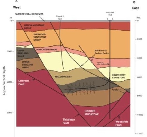
Cuadrilla is searching for shale gas in the Bowland Shale. The rock formation has had quite a complex geological history in the area. This explains why the rocks are 2km underground in the Fylde, but 17 miles away in the Bowland Fells they are found at the surface.
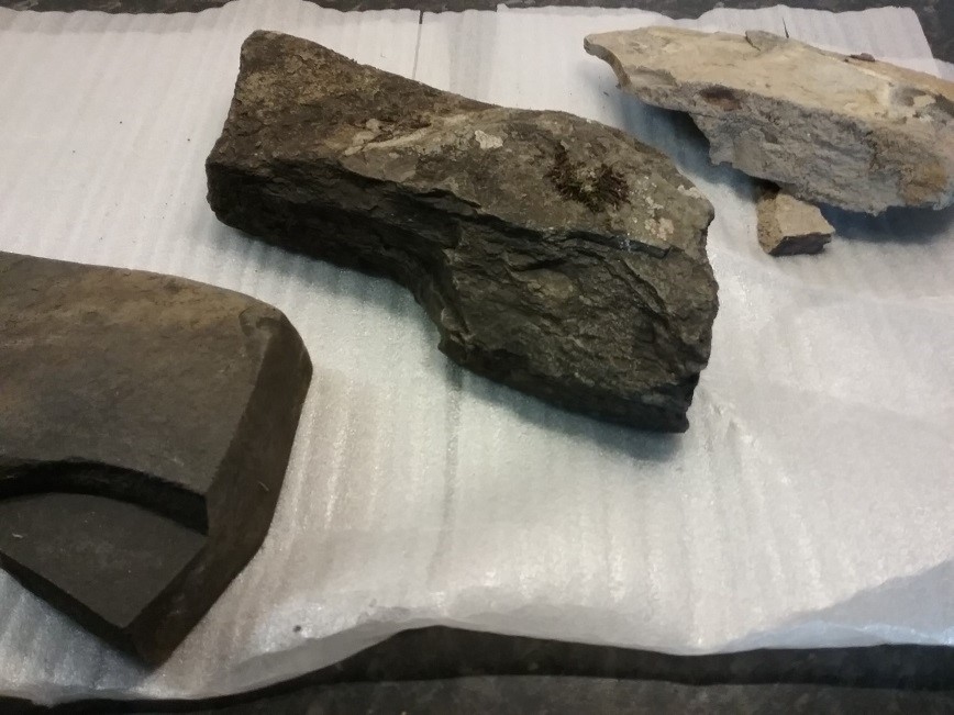
Shale rocks (from left to right): Lower Bowland Shale from dense tough bed of black cherty/siliceous limestone; Lower Bowland Shale showing layers of mud; Upper Bowland Shale, very flaky, weathering to a lighter colour on the surface. Photo: T Froud
Before Cuadrilla drilled and fracked at Preese Hall in April/May 2011, Professor Peter Styles, then at Keele University, advised the company to do a new seismic survey and install local seismic monitoring. The company didn’t.
Cuadrilla relied on an older 2D seismic survey that was offset to the planned well. This meant that it had an incomplete picture of the subsurface. During operations, fluid migrated into a fault which then slipped, caused more than 50 tremors (including one months later in Aug 2011) and deformed the well over a significant interval.
The consequences, apart from loss of the well, were a moratorium, a series of reports, reviews and studies, a growing public awareness of fracking ….. and a pause of 7 years.
The lesson learned could be summed up:
“A survey is expensive but drilling in the wrong place is a jolly sight more expensive”.
What surveys show …
A seismic survey indicates the type, thickness and depths of rock layers below the surface. It also shows the structure, such as the folds and faults resulting from geological upheavals.
Subsequently, during drilling, core samples can be taken and instrumentation used in the well to gather information about the rocks, and all this data is used to correlate with the survey results.
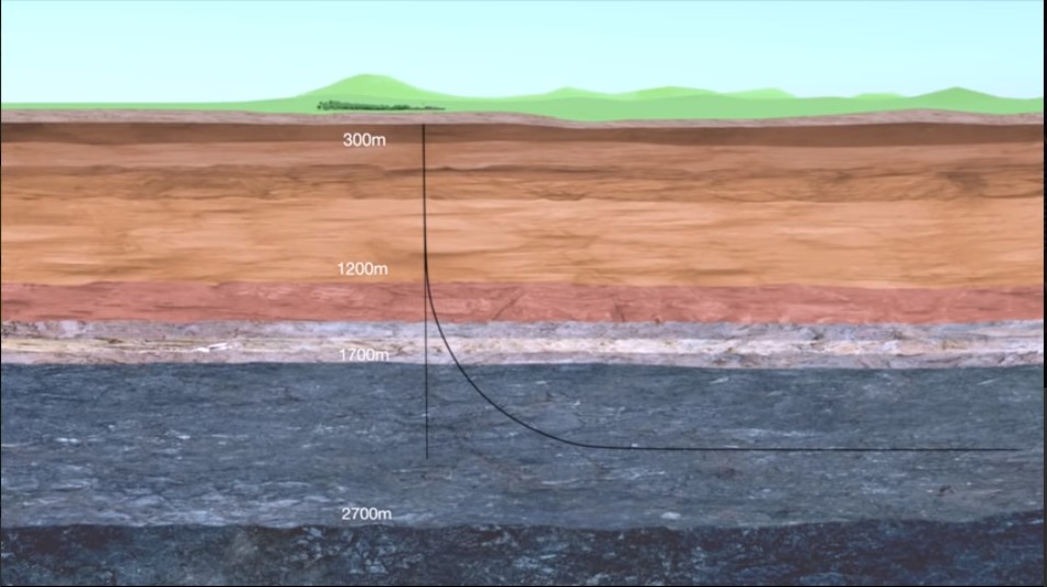
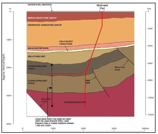
The ideal geology would be like a neat layer cake or the banner produced by Cuadrilla:
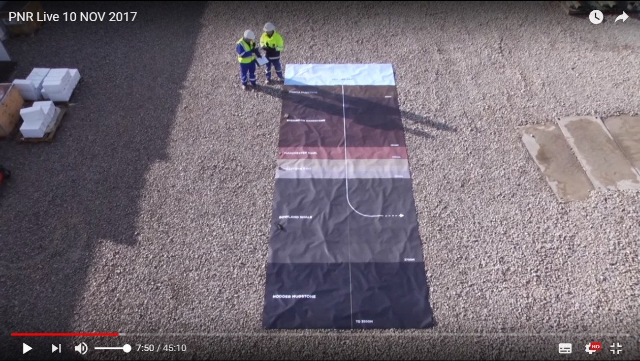
But when Cuadrilla carried out a seismic survey in 2012, the picture was rather different. The Environmental Statement for the proposed Roseacre Wood site depicted the subsurface like this:
Graphic included with Cuadrilla’s environmental statement for its Roseacre Wood site. Source: Cuadrilla Resources
Cuadrilla’s 3D seismic survey was due to be released in January 2018, but was not authorised for release until September 2018. This was too late to be reviewed by the wider scientific community, because all the permissions had been given to frack the first well at Preston New Road by that time.
So the only access that academics and independent geoscientists have had, is to tiny seismic slices and equally limited coloured interpretations of the geology, shown in the planning applications, and more recently, in the Hydraulic Fracture Plans (HFP) submitted by site operators to the regulators.

… and how the picture changed
An HFP ought to contain data that can be obtained only from drilling, and that point is made in the HFP for Kirby Misperton. However, Cuadrilla issued its HFPs before or just as it started drilling.
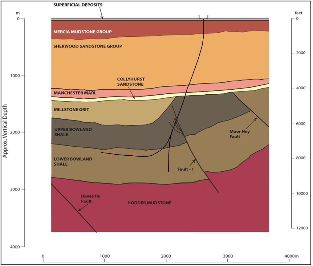
Cuadrilla’s HFP for its first well – PNR1/1z – went through several iterations before it was finally accepted and now includes data gained during drilling.
You can compare the graphic (immediately below) in the original HFP for well 1, pre-drilling and based only on the 3D survey, with the second graphic produced after drilling in the revised and longer HFP:
Graphic in the Preston New Road HFP pre-drilling and based only the 3D seismic survey. Source: Cuadrilla Resources
Graphic in the Preston New Road HFP produced after drilling. Source: Cuadrilla Resources
There are several differences between the two graphics:
- the vertical pilot hole does not go below the Lower Bowland Shale as had been proposed
- the lateral was drilled into the Lower Bowland Shale rather than the Upper Bowland Shale
And the geological interpretation has changed:
- the band of Millstone Grit Icoloured light brown) that Cuadrilla predicted from their 3D seismic survey, was simply not present at the location of the pilot well
- Fault-1 extends much higher and is now portrayed with a splay of smaller faults towards the top in the Upper Bowland Shale
- Crucially the well is drilled through the fault
Now compare this to the graphic in the HFP for well 2, issued after drilling that well.
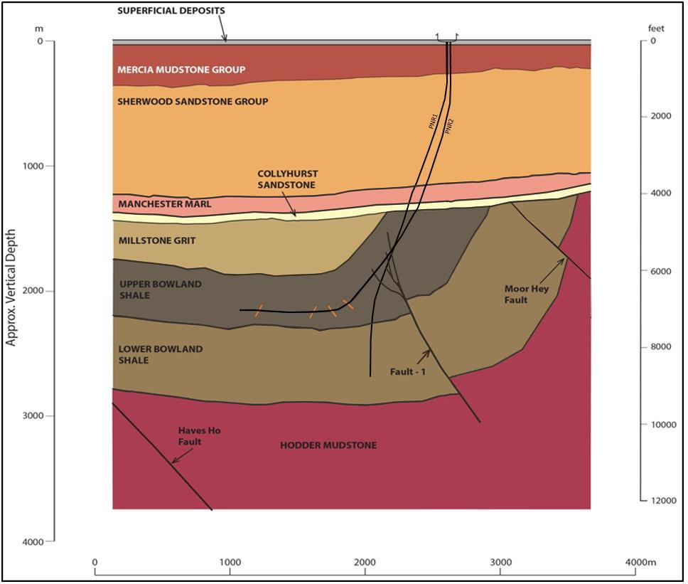
Graphic produced for the Preston New Road second well (PNR2). Source: Cuadrilla Resources
Further changes have been made. The geological interpretation close to the Moor Hey fault has changed, even though neither well was drilled nearby and no further survey has been carried out in that area.
The whole picture is very different from the graphic in the planning application made to Lancashire County Council in 2014:

Graphic in Cuadrilla’s planning application to Lancashire County Council in 2014. Source: Cuadrilla Resources
Should we trust the graphics?
Both the way the survey is carried out (the data acquisition), and the way the data is processed, can affect the results of the subsequent interpretation.
In Cuadrilla’s licence area, PEDL165, the seismic survey and the data processing were carried out by CGG Veritas, and the subsequent interpretation was by Cuadrilla.
Emeritus Professor David Smythe, formerly of Glasgow University, has had concerns for several years about the interpretation of the seismic survey, particularly the faults. He raised these issues with Lancashire County Council’s planning officers in 2014 and 2015. He discusses the issue further in this recent article.
The changes to the graphics over the last four years, show that the Cuadrilla has not found it easy to interpret the results of this 3D seismic survey.
Millstone Grit and Shale are very different rocks, and have different characteristics. Therefore, it is rather surprising to me that they expected to find 1,000ft of Millstone Grit at the location of the pilot hole, which actually turned out to be shale.
The latest HFP states:
“At the Preston New Road Site, the Millstone Grit overlies the Upper Bowland Shale. Observations in section t “Well Observation” identify the Millstone Grit to be absent at the PNR1 well pilot hole location, however 3D seismic data shows the Millstone Grit present vertically above the lateral well (PNR 1z).”
Given that this same survey data was misinterpreted at the pilot hole location, what level of confidence can the regulators have that it has now been correctly interpreted elsewhere?
And does it matter?
A full understanding of the structure of the subsurface is important. It is a necessary precursor to, and underpins the ‘safety’ of, any unconventional hydrocarbon development, because the behaviour of that structure is even less well understood.
- Faults can slip causing tremors and/or damaging well
- Faults can transmit fluids in the horizontal direction
- Faults can transmit fluids upwards
We know that a fault slipped at Preese Hall and caused deformation to the well. Professor Richard Davies, of Newcastle University and the Research in Fracking in Europe project, has raised concerns that these PNR wells are drilled through a fault, and that “if it slipped there will be a well integrity issue”.
We know that the EA analysis of the flowback fluid from the Preese Hall well showed that it contained a wide range of salts, heavy metals, low level radiation, all of which came from the shale. Some of these substances were at many times the concentrations found in the drinking quality water that was used to frack. We also know that Cuadrilla’s former Technical Director Andrew Quarles said in 2015:
“We have been estimating we will get back 40% of flowback. There are lots of theories. No-one knows exactly what is going on or where the water goes or where the final resting place is.The water could go into the fractures created by fracking or it could be absorbed into the shale formation”
We know from Cuadrilla’s geologist, Huw Clarke that the Morecambe Bay gas fields were formed when Bowland Shale gas migrated up through faults in the Manchester Marl, collecting in the Sherwood Sandstone Group.
The mechanism of induced seismicity is not fully understood and is the subject of current research. The effect of faults on the compartmentalisation of groundwater is also a current research paper.
A group of geoscientists from Durham and Newcastle Universities have said:
“The shale formations that are currently targeted by fracking in England are highly (naturally) faulted. … The new challenge, however, is working out how stressed these faults are.”
Commenting on the recent tremors, Professor Stuart Haszeldine, at the University of Edinburgh, said:
“The practical significance is … in the potential to damage the borehole, and the potential to create gas pathways from the shale towards larger faults, towards shallower aquifers, and to the surface”.
There are a lot of unknowns and yet academic recommendations to minimise the risks – for example by maintaining a respect distance from faults proposed by Professor Styles – have not been heeded.
The risks of delayed data release
I have no doubt that interpreting the results of a 3D seismic survey is a specialist skill, and clearly Cuadrilla experienced difficulties.
I observe that the company had five years to study the data. If the results were not sufficient to assess properly the subsurface at Preston New Road, the company had the option to re-run a limited survey for these wells or reprocess the data in that area. This is particularly important when drilling proved that the Millstone Grit was not present.
Cuadrilla’s 3D seismic survey was due to be released under the terms of their licences (for PEDL 165, EXL 269), in January 2018, but Cuadrilla asked the industry regulator, the Oil & Gas Authority to withhold it.
If the data had been released in January 2018, independent scientists would have had time to assess these interpretations and raise any concerns about, for example, the position of faults relative to the wells or the location of British Geological Survey (BGS) groundwater monitoring stations relative to the faults.
To the best of my knowledge, neither Liverpool University, which has been working on triggers of induced seismicity, nor the Durham/Newcastle and ReFINE geoscientists working with Professor Davies, have seen the data. When last I asked, the BGS had not seen the data either, and of the three regulators, only the OGA has had access.
The issues that concern Fylde residents near the well sites are not about seismicity that can be felt on the surface. They are all about what is happening subsurface and which could have long-term consequences.
Exploration for hydrocarbons should be conducted with the stewardship of the environment in mind. The subsurface and its behaviour are unknowns, and fracking is such a controversial topic, that the survey data needs to be viewed by the other regulators and examined by independent experienced scientists before any further exploration is carried out.
In particular, it is of deep concern to me as a resident, that regulators who are making crucial decisions about fracking, are doing this ‘blind’.
Categories: guest post


The lengthy comment from Judith Green (above, November 18, 12:11pm) comes from someone who is too ready to criticise the professional opinions of others, but as is customary with the pro-fracking apologists, fails to disclose her own qualifications, professional experience, and possible links to the hydrocarbon industry.
Ms Green starts off:
“…the writer has significant gaps in their [sic] knowledge and understanding of the subject.”
No, Ms Green, it is you that is lacking in knowledge and understanding. Permit me to explain.
You dismiss Ms Froud’s comment that the Bowland Shale geology is quite complex, by stating:
“…anyone with a solid knowledge of geology wouldn’t jump to a conclusion that 2km difference in burial depth is evidence of complex geology. A slow angle dip [sic] of the bedding would cause such an observation but one would hardly classify that has complex geology.”
You miss the general point that Ms Froud is making, which is, although the 2 km burial depth of the shale at PNR has no direct bearing on the complexity or otherwise of the shale, it does confirm a geological history which is complex compared to, say the shale basins of North America. The evidence both from outcrop in the Bowland Fells and from the seismic data in the Fylde confirms that the Bowland Shale is indeed complex, being highly faulted and folded. Your speculation about a gentle dip (“slow angle dip”) is speculation, not supported by the facts.
You deny that fluid flow (from fracking of stage 2 at Preese Hall-1) need have lubricated a fault, and thereby caused the seismicity. This is contrary to the accepted conclusion that this was the primary cause of the seismicity in 2011. You state: “Faults can reactivate as a result of stress transfer – there is no need for fluid to have entered a fault.” What do you mean by ‘stress transfer’? Do you mean the extra component of hydrostatic stress induced in the frack zone by injection indirectly causing a fault some 500 m away to slip, because the elastic stress tensor in the neighbourhood of the fault has changed (in some unspecified manner)? If so, why then was there a ten hour delay between the end of an injection stage and the triggering of the two biggest tremors in each case (M = 1.5 and M = 2.3)? On your speculative hypothesis the triggering would have been instantaneous.
Again, in ignorance, you propose:
“The author seems to be suggesting that had a 3D survey been conducted then the seismicity at Preese Hall would have been avoided. However, unless the author has compared the 2D and 3D surveys then there is no reason to suspect that the new [3D] survey provides information that would have allowed seismicity to be avoided.”
On the contrary; Ms Froud is not suggesting that the seismicity could have been avoided, but if the 3D survey had been available before PH-1 was drilled then the fault that it intersected, and which then slipped after being lubricated by fracking, might have been avoided. Before the 3D survey was shot in 2012 the nearly vertical well PH-1 was deviated slightly to the east in the shale to avoid two faults interpreted on the E-W seismic line GC83-352, 400 m north of the drillpad. But these two particular mapped faults, based on a single 35-year old 2D line, do not exist in the 3D volume, although there are plenty of other faults.
The author may not herself have compared the 2D and the 3D surveys directly, but she has corresponded regularly with me, and I can now compare the two datasets. I can assure you that the vertical seismic slice from the 3D survey (Inline 5118) corresponding to the 2D survey line mentioned above is very different in fault detail from the 1983-vintage 2D line. At PH-1 I can map in the 3D volume a thrust fault trending NNE-SSW which comes upwards from depth and forks, the upper prong intersecting the lower wellbore and the lower prong reaching the toe of the well.
Your comments about the possible similarities between the Millstone Grit and the Bowland Shale, throwing in quasi-technical phrases like “vertical P-wave velocities”and “the same P-wave impedance”, are no more than specious waffle, in the absence of detailed quantitative backup, and appear to be designed firstly, to impress the non-technical reader, and secondly to let Cuadrilla off the hook:
“… this explains why the Millstone grit wasn’t mapped accurately by Cuadrilla”.
You conclude, furthermore, “that others wouldn’t be able to have done a better job”.
I am sorry to inform you that it is quite easy for others such as myself, expert in seismic acquisition, interpretation and in structural geology, to do a “better job” – once they are permitted access to the full data. I have only had access to the 3D survey for 12 days, and can already explain why the Millstone Grit is absent at PNR but present at PH-1. It confirms my long-held view that Cuadrilla is technically incompetent, both in drilling and in geological understanding. A detailed report on my preliminary findings is currently with the EA, which has agreed to examine it in detail before making a decision about whether or not to issue approval for the Hydraulic Fracture Plan for PNR-2.
You make some comments about well leakage, with the generalisation that:
” … wells experience significant deformation. However, this doesn’t lead to leakage of fluids to the surface because cement higher up the well prevents such leakage.”
Evidently you are unaware of PH-1 having leaked after it was plugged – so much for your complacent view of cement bonds. The fact is that all wells leak, whether starting on day one, or after 50 years (look up Anthony Ingraffea, Emeritus Professor of Mechanical Engineering at Cornell University, for the details). There is absolutely no need for you to disparage the qualifications of Stuart Haszeldine:
“… the author provides a quote from Stuart Haszeldine about well bore integrity without pointing out to the readers that Prof Haszledine had no expertise in either geomechanics or well bore integrity.”
– because Stuart well understands enough of the subject, by reading around (e.g. the work of Anthony Ingraffea), even if it is not his own specific area of expertise, which is petroleum geology. You seem to take a dim view of academics like us, believing that we all have our little compartmentalised boxes of expertise, and that we are unable to relate our own expertise to that of those in neighbouring disciplines.
The rest of your comment deteriorates further, into [edited by moderator] Cuadrilla doing a sound job, about how you allegedly seem to know personally other seismic experts, and how Cuadrilla doesn’t need the input of “self-appointed seismic interpretation experts in the anti-fracking community” – to which a response is not merited.
Lastly, I reiterate my request for you, Ms Green, to tell us exactly why you are qualified to comment. Your knowledge of geology, seismicity and hydrocarbon exploration is clearly very limited.
It’s interesting to have my knowledge of geology questioned by a person who can’t even get his ideas on the subject past peer review. I wonder why that is [edited by moderator]
To answer your points individually,
1) I didn’t question the complexity of the geology. I simply questioned the evidence that the author used as an indication of complexity. As you admit, it would be quite easy for a generally dipping bed to at surface in one location and buried at 2km elsewhere. The geology around PNR is moderately complex but nothing to unusual.
2) The geological history around PNR is more complex than many parts of the Barnett but not particularly complex compared to other unconventional plays in for example Canada. The fact that it has been uplifted isn’t work mentioning as most of the productive plays have been uplifted, which is part of the reason that most are overpressured.
3) You comment about stress transfer indicates that you haven’t been making much use of the literature since having your rights to the library in Glasgow reinstated. There are a huge number of examples where injection of fluids or reducing injection causes impact at a distance from the wellbore. Kes Heffer and Ian Main have published on these. As you mention, the propagation of an elastic wave cannot be responsible given the high time delay. There are currently several ideas around the causes including propagation of a damage wave, propagation of a poroelastic response etc. I think it’s fair to say that the mechanisms are not well known but it is clear that in many situations this could not possibly be caused by the propagation of a pressure wave within the fluid itself. If you ever find time to read academic articles again, it might be worth increasing your knowledge of soft rock mechanics – I often find that people like you who have spent their lives in the brittle – elastic domain get things wrong.
4) You state that Ms Froud isn’t suggesting that seismicity could have been avoided and then you say it could have been avoided – which is it? You seem to have quite a simplistic view of seismic interpretation. What would you say were the accuracy of fault interpretations in a lateral sense – ¼ of the wavelength of the seismic, the width of the fresnel zone or something different? I would say that its far more and 3D seismic might be able to pick up faults with 30 m offset by the accuracy of their lateral location is something like 400m. In other words, seismic isn’t that great at picking up and accurately locating faults. Instead, if you’re worried about faults in wellbores one should run tools such as the sonic scanner and look at the frequency content of the Stoneley and flexural wave.
5) You’re mapping of a thrust fault is interesting – I’ve never seen much evidence of thrusts in these sequences in this area – maybe you might eventually get something published with such a ground breaking observation.
6) [Edited by moderator]
7) In terms of my comments about the impedance contrast between the millstone grit and the shale, could you provide another mechanism to explain the lack of reflectivity from the interface? I can have a pretty good guess at the impedance contrast between these two interfaces given that they have a porosity of <10% and I can totally see why there would be a lack of reflectivity. Have you got any better sugestions???
8) Are you seriously claiming to be an expert in structural geology [edited by moderator]
9) Your comments on well bore integrity are rubbish – it is clearly not your subject and you seem to quote two others who have little knowledge of the subject. I know exactly who Ingraffea is. Unfortunately, he seems to use to annulus pressure as evidence of well bore leakage – maybe when he’s shown evidence of hydrocarbons or brines leaking to the surface due to deformed well bores then people might take him seriously. [edited by moderator]
10) I take a dim view of what Stuart writes because I know his expertise pretty well. [Edited by moderator]Just look at [edited by moderator] [what] he wrote about fault-related cementation of sandstones – I think you’ll struggle to find another geoscientist who gives such ideas any worth.
11) I’m not sure why you don’t think a response is merited to my point regarding the expertise in Cuadrilla and the expertise that it employs. One only has to look at the technical director who has had a brilliant career in industry and done amazing work in his previous jobs.
[Edited by moderator]
[Edited by moderator]
We still don’t seem to know what qualifications [Judith] has to disrepect academics do we?
Apparently Judith ‘did a PhD in chemistry many years ago strangely doesn’t mean that I can’t pick up other subjects. For the last 20 years I’ve consulted on environmental aspects associated with the oil and gas industry. I’m also fortunate enough to have a partner who specializes in seismology..’
https://drillordrop.com/2018/11/12/guest-post-save-the-fylde-keep-the-earthquake-safety-limit-at-0-5/
Funny how she clearly thinks it is reasonable that she should be able to pick up other areas of expertise but she won’t extend the same privilege or courtesy to others isn’t it?
So she has no qualification in geology or anything related then, but she knows someone who has?
OK 😏
So if I’ve got so little knowledge of geology you should easy be able to pick my arguments apart [edited by moderator]
I’ll leave that to those better qualified than me Judith. I thikn David did a pretty good job on your arguments above.
[Edited by moderator]
“I thikn David did a pretty good job on your arguments above” is too specific is it. It rather comes over as someone who doesn’t understand the issues and claps the person who says what they want to hear. [Edited by moderator]
Or maybe as somebody who doesn’t feel the need to denigrate everybody and anybody they disagree with Judith? Hmm.
Refraction – do you have some sort of phobia about addressing arguements instead of trying to score petty points on unrelated subjects. Maybe a black belt in onehobsmanship makes it difficult to change
See what I mean Judith 🙄
It seems” the casualty of war is tthe truth”.
Both sides accuse each others of incompetence and lack of understanding of technical experience while the public dont have the technical are being manipulated by scaremongering technical jargons.
Of course the frackers have their own expert opinion as do the anti frackers. Why should they take the theoretical interpretation of the other side as gospel.
Layman can only make judgement by the fact that all the scaremongering stories are not fact after ten of thousands wells are fracked in US and no nightmare dramas as claimed by the anti frackers.
You were doing really well until the last sentence TW 🙂
Apart from TW is correct – not a single member of the public has been injured, killed or made ill as a direct result of fracking
Judith Green, I was quite enjoying your banter with my knowledgable anti fracking friends until your last sentence.
Please refer yourself to the List of the Harmed for over 200 pages of multi-victim incidents of harm inflicted to people, animals, water supplies and the environment in general by fracking and the oil and gas industry in general.
Sorry but now I know you are nothing but a fracking propaganda merchant.
The list of the harmed is not evidence-based. It just documents any case where someone believes that fracking has done them harm. Could you imagine what would happen if they had a list of people who had tripped up on pavements or had whiplash in Liverpool? One could reach a conclusion that such incidents were more common in Liverpool rather than thinking that there is more of a compensation culture in that city than elsewhere.
The list of the Harmed has links to the actual events that can easily be followed up.
Not all are operating as time moves on and court cases are finalised.
Local papers usually report the truth, even on the Fylde!
Peter – local papers haven’t the knowledge to critically appraise the evidence. The fact that you pay any attention to the list of the harmed also shows you have zero ability to critically appraise evidence. [edited by moderator] Come on – go the whole hog and cite Gaslands
Fracking linked to low-weight babies
https://www.sciencemag.org/news/2017/12/fracking-linked-low-weight-babies
Fracking Is Dangerous To Your Health — Here’s Why
https://www.google.co.uk/url?sa=i&source=web&cd=&ved=2ahUKEwiPotjx-d7eAhUCSxoKHZfwAw8QzPwBegQIARAC&url=https%3A%2F%2Fwww.forbes.com%2Fsites%2Fjudystone%2F2017%2F02%2F23%2Ffracking-is-dangerous-to-your-health-heres-why%2F&psig=AOvVaw17_23YQy4Tz60tIkl_ISFU&ust=1542665213417138
If anyone is in any doubt about the risks associated with Fracking , I can supply an almost endless list for your consideration.
You might need to look up the difference between correlation and cause
Jack
Low weight babies linked to well sites in Pennsylvania, Blackpool and other parts of Lancashire.
Blackpool exhibits a higher risk of low birth weight (25%) than the uk average, and Darwen higher risk than that. Seems that some causes exist outwith being near drill sites.
Good study, but the follow up would be interesting …. that links the proximity to the well sites and anything that contributes to a lower birth weight than the state average..tho the best place to be is North Dakota and the worst Mississippi, on average.
Parental Economic social and education status has been shown to linked to birth weight.
Tje influx of rough neck to the industry may skew the statistic outcome of the regional survey and data collected.
In scientific research correlation doesn’t mean it is neccessary the cause. The level of correlation is important. If R2 value is not statistically significant than the observation is just due to random chance.
Arm with these number and study why havent they gone to court? Obviously their statical power is not enough to support the anti fracking claims.
The confounding factors maybe not directly fracking but due to other social activities that are associated with the industry in general. And the increased risk is so small that it maybe just random chance.
You want me to give you a scientific expert arguements to your comment Sherwufle??
Here it is.
“Bite me! Bite me!”
“Whatever! Whatever!”
“You feel me???”
The flood of fracking induced tremors in the Fylde during 2011 and 2018, as well as the subsequent well damage, provide sufficient evidence to confirm that the ‘scaremongering’ / warnings were justified. Hiding the evidence of subsequent pollution is a given as that is the norm in the USA too.
That’s right – one could observe the corpses littering the streets of the Fylde
Ms Green [edited by moderator] You refuse on spurious grounds to release details of your qualifications, so I can assume that you have none of relevance.
Points 1 and 2: Complexity of the geology. The Bowland Basin is much more complex geologically than practically all areas of all the North American shale basins (there are local exceptions, of course), and the other important difference is that the shale is an order of magnitude thicker.
Point 3: Stress transfer. The best and most straightforward answer to the triggering ‘at distance’ (a few hundred metres) remains fluid flow along hydraulically created and/or natural fractures. This has been demonstrated in a field experiment where fluid was injected into a fault via a borehole rigged up to measure the slip (most of which was aseismic) and by several modelling studies. The industry also accepts that casing failure under shear and accompanying seismicity is caused by fluid injection. So if you have some novel ideas on this I suggest you try to get them published.
Point 4: “Simplistic view” of seismic interpretation and fault location. This section, peppered with technical phrases like the quarter-wavelength criterion, the Fresnel zone, etc. illustrates your astonishing level of ignorance. Modern 3D methods resolve faults far, far better than your claimed limits of 30 m vertical offset resolution and 400 m lateral resolution. I write as the “simplistic” leader of the first academic group in the world to use the 3D seismic reflection method, back in 1994, when the method was only just coming of age in the oil industry. In the Fylde the Cuadrilla 3D has a horizontal resolution of as good as 1 CDP bin width (25 m) and a vertical resolution (one-tenth of the dominant wavelength is the accepted criterion in 3D) of 4 to 5 m.
Incidentally, I withdraw (in part) my comments about the poor quality of the 3D survey, now that I have it in front of me. The imaging of the shallow (Permian-Triassic) cover rocks does suffer locally from low fold of coverage due to areas of the field survey being skipped, but at depth the imaging of the shale can be excellent, thanks to the sensible choice of dynamite as the source and not vibrators. I write this “simplistically” as one whose PhD fieldwork was in dynamite seismic reflection (1970-73), and as the former owner of two vibroseis trucks.
Point 5: Thrust faulting. Everyone in the know (except you, its seems) knows that are reverse, or thrust, faults in the shale, also with a strike-slip component – very complicated to decipher. My observation is not new. I am “simplistically” mapping them with more precision than Cuadrilla seems to be able to manage. But you write “I’ve never seen much evidence of thrusts in these sequences in this area”. So you are indeed a geologist, are you? I suggest you contact the Cuadrilla exploration guys with your observations ASAP, which will be new to them as well.
Point 8: Expertise in structural geology. Modern structural geology has learned much from the revolution in seismic reflection imaging of the last 40 years. No serious structural geologist can ignore what seismic has to offer. I write as someone who “simplistically” published his first paper (1971) in the field of structural geology (based on my undergraduate field mapping project), who identified thrust faults by deep seismic imaging (from the surface down to 100 km depth, published in Nature, 1982), and who was invited by a Harvard researcher on a private field trip in 1986, along with three structural geologists from Cambridge and a bunch of Americans, to look at thrust faults at outcrop in Nevada. The aim was to compare the field evidence with the seismic evidence. The point is that structural geology and seismic reflection interpretation have converged to become a common area of expertise, and you have to have a foot in both camps to be a leader in that field.
Points 6, 9 and 10 are ad hominem insults directed at myself and respected colleagues. Professor Ingraffea (Cornell University, one of the world’s best) was instrumental in getting shale exploration banned in New York State. Prof Haszeldine was at a young age made a professor at Edinburgh, another one of the world’s top universities (much more renowned than Glasgow, I have to admit).
Point 11: Expertise of Cuadrilla. If the in-house expertise is so brilliant, as you claim, why has its geological interpretation of the PNR area changed so fundamentally, as Ms Froud has so eloquently demonstrated? Let us see whether the EA accepts my findings.
“Professor” Smythe – I’m not surprised you want to get away from my comments regarding your ideas on fracking being rejected by the academic community as that might insinuate that your ideas have no merit. However, it does seem odd that you are critical of me for ad hominem comments yet seem to want to see my qualifications – surely you should be able to judge my knowledge from what I write rather than viewing certificates. [edited by moderator]
Point 1-2 In terms of complexity of geology, I think that one first needs to define what you mean by shale basin. I’ve worked in many so called shale basins that are in fact fractured carbonates or sandstones. On the other hand, I’ve worked on what are called tight gas sandstones that are in fact shales. I’ve worked on many areas that are far where fracking is occurring every day that are far more complex than the Bowland. Indeed, in some areas the statics are so difficult to remove due to glacial fills of deep valleys that seismic is almost non existent and we’ve had to rely on structural reconstructions to guess what the subsurface is like.
Point 3 – You are clearly pretty out of the loop regarding stress transfer. Obviously, injection of fluid along a fault is a good possibility. However, on the wider scale doesn’t explain coupling of production and injection in wells that are many kms away in which it would be impossible for dilatant faults and fractures to exist given the rheology, total stress conditions and pore pressure at depth. You have clearly not worked very much in industry if you think that “the industry also accepts that casing failure under shear and accompanying seismicity is caused by fluid injection”. Do you really thing that casing failure in the overburden of Valhall, Ekofisk, Yibal etc were caused by fluid injection? Maybe you could point readers to situation where casing failure or even seismicity has led to leakage. The anti-frackers for some reason seem to concentrate on Groningen despite the fact that it hasn’t been fracked yet fail to highlight the fact that there are zero cases of leakage despite the fact that earthquakes are being triggered in the reservoir itself.
Point 4: “Simplistic view” it’s interesting that you claim modern 3D seismic methods have far better accuracy than I suggested. Again this shows that you haven’t done much with such data for a long time. Have you actually every laid interpretations from several 3D seismic surveys from the same field on top of each other and even compared them to interpretations from the same survey that has been processed in a slightly different way? Have you ever been to a core store to view a fault that was supposed to have been cored based on the interpretation of 3D seismic data and found that the fault was missed? Clearly not. So although you might have done some good work in the past it’s pretty clear that you’re not up-to-date. P.s. you seem to be mistaking resolution and accuracy in your arguments.
I must admit I do agree that dynamite can be good particularly when looking at the frequency dependence of certain seismic attributes. However, I’ve also seen excellent results from vibroseis particularly when a shear wave source has been used and 3C receivers deployed. However, it’s nice to see that like many academics you still overly value your PhD research.
Point 5: Thrust faulting. I didn’t argue that thrust faults don’t exist in shale I simply commented that I’d not seen them in outcrop in the NW and would be rather surprised if they occurred beneath PNR.
Point 8: Expertise in structural geology. I agree that modern structural geology has learnt much from 3D seismic. However, it has also learned a lot from geomechanical modelling and critical state soil mechanics particularly about when faults do and do not dilate. It is clear from the paper that you tried to publish that this is an area that has passed you by. I wouldn’t worry too much about it – most hard rock geologists are afflicted by the same blindness. Your publications are truly impressive – it’s rather a pity that other academics don’t think the same given the number of citations that they received. Although I guess they were written so long ago that people didn’t have google to help them hunt out such brilliant works
Points 6, 9 and 10 Wow – Anthony was instrumental in getting fracking stopped – that really shows how much his work is respected. Do you not think his criterial for leakage based on annulus pressures in boreholes in the GOM is sound? Why hasn’t he produced evidence of leakage to the surface. It’s interesting that you think Edinburgh is one of the best Universities in the world – it’s geology department didn’t do too well in the REF did it? It simply showed they had a great deal of pretty mediocre staff. In terms of Stuart, are you really trying to defend the quality of his science???
Point 11: I doubt EA will read your findings [edited by moderator]
You didn’t whether the reflection from the Millstone grit and the underlying shale was clear on the 3D seismic? It would have been interesting if Cuadrilla had given you the 3D seismic to interpret before they drilled the well – that would have been a true test of your extraordinary seismic interpretation skills.
Pity Cuadrilla decided to ask the industry regulator, the Oil & Gas Authority to withhold it then eh?
Not really – the last thing that would be useful is our nation full of fracking experts putting in their ill-informed opinions. Although, I’m sure Cuadrilla really missed out from having Danny the Lions interpretation.
You can’t help yourself Judith can you?
Yes, and without this information available permission was given to go ahead and frack by the government; stinks to high heaven
There is no where else I know of where such data would be made publically available – why do you think PNR is different to every where else in the world?
Judith; I may call you Judith? Or should we resort to formalities?
‘Cuadrilla’s 3D seismic survey was due to be released in January 2018, but was not authorised for release until September 2018.
This was too late to be reviewed by the wider scientific community, because all the permissions had been given to frack the first well at Preston New Road by that time’
So I ask you why was it delayed?
It was ultimately released so your statement ‘There is no where else I know of where such data would be made publically available’ is invalid.
Yes I can smell the methane emissions from here…….
Hmmmm
Well, we can look forwards to the uncomplicated shale East of the Pennines even if the Bowland Shale be a bit too tricky?
Lots of Seismic ( other than under Clumber ) for INEOS, tho perhaps not as much for Tinkers Lane and Misson, but drilling first to see what is there I guess.
Plus lots of knowledge of what’s in the bit between the surface and bottom of the coal measures where worked.
How can anyone fall out over that.
Ms Green: I judge you on what you write, and it is wanting at many places. The give-away is the use of certain phrases that a professional earth scientist would never employ; but no matter. It appears that you do work in the hydrocarbon industry in some capacity, but you never clarify whether your experience of fracking actually comes from work on horizontal wells in shale. I know that a lot of fracking is carried out in carbonates and sandstones (tight or otherwise) in conventional fields, but this experience, which is what you seem to have by your references to conventional North Sea fields, has limited relevance to high-volume horizontal fracking of shale. So your references to casing failure at Valhall etc. are irrelevant.
You are forced admit that my estimates of the resolution of 3D seismic are correct, whereas yours are an order of magnitude too large. I never confuse resolution and accuracy. I am also well aware of the differences that can result from minor changes in processing. I have my own licence for Promax3D on a Linux computer, which, thankfully, I rarely have to fire up because seismic processing is tedious and hard work.
You refer indirectly to my 2016 Solid Earth Discussions paper. I withdrew this after consultation with the editor, partly because the whole set of comments and replies had grown so large that it would have been hard to edit; it was also my own fault for trying to cover too many subjects in one paper; I did this because I am not interested in numbers of publications. However, I believe that I had dealt satisfactorily with all the critical comments. It is noteworthy that most of the comments came from academics funded (or wannabe funded) by the industry. Nevertheless I responded to them all at face value. One referee’s comment (Haszeldine) was favourable, one (Aplin, Leeds) was negative (but full of unsustainable comments – one I remember is that I had selected a particular borehole ‘at random’ in Lancashire, when I had in fact discussed the crucial Kirkham borehole); the other two referees’ comments (adverse) were very short but difficult to understand, written in poor English, and seem to have been eventually elicited by the Italian editor, perhaps from colleagues in his own country unfamiliar with fracking. So while my paper became a bit of a mess, there is still much sound stuff in it, and I intend to resubmit it, this time divided into bite-size chunks.
You write:
“You didn’t whether the reflection from the Millstone grit and the underlying shale was clear on the 3D seismic? It would have been interesting if Cuadrilla had given you the 3D seismic to interpret before they drilled the well – that would have been a true test of your extraordinary seismic interpretation skills.”
The Millstone Grit is a seismically well-layered synclinal sequence to the north of my NE-SW Weeton reverse/wrench fault on the 3D that ties in perfectly to Preese Hall-1. In contrast, reflections from the underlying Upper Bowland are very weak. The Grit is upturned steeply against this fault, to the south of which it is completely absent. There is no doubt about this in my view, and the Upper and Lower Bowland sequences to the south do not change in character. Furthermore, the Bowland does not section-balance on any N-S line – a sure sign that transcurrent faulting is at play. Not rocket science. So yes, I would have come to the same interpretation, had I had access to the 3D data a year ago, before PNR-1 was drilled. Incidentally I am using the industry-standard IHS Kingdom package, version 8.8, for interpretation.
The question for the EA is whether they will accept my review, or try to stick with the evidently untenable interpretation still being proposed by Cuadrilla, as pointed out by Tina Froud in her article above. All we are asking the EA to do is to regulate properly, by requiring Cuadrilla to re-interpret the geology around the wellsite properly, so that it can be reconciled with the seismic and the adjacent well tie – not an unreasonable demand.
I’ve done environmental assessments on both conventional and unconventional oil and gas fields throughout the world. My point about Valhall is entirely relevant in that it had many localised well bore failures yet no leakage. I don’t see why you find that difficult to understand other than it doesn’t fit in with your little narrative about deformed boreholes creating leakage pathways.
I wasn’t talking about resolution I was talking about accuracy which are totally different thing as you know. The fact that different interpretations of even the same 3D seismic can be different by over 400 m gives one a reasonable idea of accuracy. Resolutions doesn’t mean to much when a high resolution section is out by 400 m. If you had bothered to fire up promax and process and conduct anisotropic processing (which will be needed for shale sequences with in excess of 30% elastic anisotropy) you might appreciate how one can easily alter the lateral position of faults etc. Indeed, I’ve seen many surveys in which faults appear to be normal after one type of processing and then are reverse after another.
[Edited by moderator] You seem to discount the comments of people who reviewed your paper just because they work for industry. That is arrogant and nonsense. There are very few academics who get funded by the shale gas industry because shale gas extraction is essentially an engineering issue – one doesn’t need too much geology particularly after appraisal. The comments by people like Terry Engelder were totally sound and I can’t see how you could have addressed them in a sensible manner.
It isn’t clear to me whether or not you are saying that the interface between the Millstone grit and the shale is easy to pick. The few lines from the 3Dsurvey that I’ve seen certainly do not suggest that it’s easy to pick. I’m also surprised that you jump to the conclusion of transcurrent deformation just because your section doesn’t balance. First of all, it is assuming your interpretation is correct. Secondly, I wouldn’t put much faith in using kinematic restoration in a sequence that has likely undergone significant ductile/plastic deformation.
I don’t really see such a great need to re-intepret the seismic. Claire Bond (Aberdeen) has shown the massive range of interpretations that are provided when the same seismic line is given to a large number of interpreters. This makes me very skeptical of any interpretation. I therefore always recommend that companies do a huge number of realizations/models and then match those realizations to production data as well as running forward seismic modelling on each model and matching that with the real seismic data. I really don’t see how any of this makes any difference at PNR given that there has never been a single gas of injury as a result of a fracking-related earthquake and there is zero chance of drinking water contamination.
Overall, it seems a very similar situation to when any of my friends go to get planning consent for developments (non petroleum related) in areas with lots of retired people – they all have too much time on their hands and get overly obsessed by things that at the end of the day don’t make any difference. Although you clearly have, for whatever reason, a bee in your bonnet about the petroleum industry, it’s worth remembering that it has an amazing safety record and nothing really causes worries when one is constructing a risk register for an unconventional development. I wish I could say the same for conventional oil and gas developments!
This is not a judgement on your credentials Judith Green, whatever they may/not be, but you write like a self-taught rooky “engineer”, clearly with some skin in the game and a lot to prove.
I was intrigued by your argument that gravity is a stronger determinant of fluid/gas migration – it would seem – than the elevated pressures at the target depths in question, not to mention the many extra 1000s of pounds-per-sq-inch added by the fracking process. Have I misread you? Please elucidate if so.
Firstly hydrocarbon migration tends to be driven by buoyancy and capillary forces (these are often quantified by the use of bond number and capillary number). Secondly, it’s wrong to think of brine flow as being driven by pressure because as I wrote in a post above, water pressure increases with depth but this in itself doesn’t result in fluid flow. Instead, fluid flow follows parallel to potentiometric surfaces. This is all covered in all covered in the classic textbook by Eric Dahlberg. All of this means is that the flow of hydrocarbons and brine often occurs in differing directions as they are controlled by different forces.
And on that subject, it’s also worth think of the impact of viscosity and compressibility on fluid flow. Although it’s rather counterintuitive, it is generally faster for water pressures to equilibrate across a fault than it is for gas pressures to do so. This is because water is so incompressible that only a small volume is needed for pressure equilibration to occur. Whereas for gas pressure to equilibrate a far larger volume of gas needs to expand across the fault and despite having over an order of magnitude lower viscosity this doesn’t make up for the impact that compressibility has on subsurface flow and pressure equilibration.
From a common sense point of view. I find the argument from the anti frackers about the upward mobility doesnt make sense.
If there is a connected pathways from the above aquifers and the fault and the fractured rock then shouldn’t the above aquifers drained into these cracks and into the faults rather the fracking fluid migrate up through those same cracks. Anyway the fracking fluid is thicker and more salty and therefore heavier than the aquifer water so the heavier water will sink. You can pretty much observe this when mix salty water with fresh water.
Also the amount of fracking fluids is miniscule compared to the aquifers volume and will be diluted out to almost zero concentration.
Hint – 10,000 psi (or thereabouts) from below … methane migration, along with impurities, are the larger issue for groundwater contamination. Many studies show these existing in higher concentrations in relation to well proximity. The disposal of recovered flowback brine is another big issue but I’m familiar with that as a post/fracking problem. The debate here seems to be about lubricating existing faults, related seismicity and additional pathways for fluid/gas migration.
Your narrative about methane contamination isn’t backed up by the isotopic composition of methane in ground waters.
Ms Green; you state (a propos of my 2016 shale discussion paper):
“You seem to discount the comments of people who reviewed your paper just because they work for industry. That is arrogant and nonsense.”
On the contrary, I took all comments at their face value and replied politely and at length.
“The comments by people like Terry Engelder were totally sound and I can’t see how you could have addressed them in a sensible manner.”
You evidently didn’t read my reply to Engelder, which countered all his arguments, except where he was correct that I had misinterpreted the conclusions that had been drawn by the authors of the Bradford County water well contamination case history. This had been originally published by Llewellyn et al. (2015), and included a couple of Engelder’s Penn State colleagues as co-authors. His comment was useful because it led me to have a closer look at that case history. But you evidently did not read my additional work (intended as a Supplement, but really another paper in its own right!) which showed that Llewellyn’s conclusions on the origin of the contamination are geologically implausible, whereas once the horizontal well tracks are added in (omitted by the original authors), it is much more likely that contamination flowed directly upwards along the fault from the eastern wing of the frack zone straight to the water wells. Please have a look at it.
I don’t see much point in arguing with you about the finer details of the 3D survey when you don’t have it. But the Base Millstone grit is easy to pick, although it is not the basal reflector of the sequence. The lowermost strong reflector (presumably within the Upper Bowland) is 100 ms deeper. Your conclusion that you don’t see a need to reinterpret the seismic is lazy and complacent. Surely Cuadrilla could have got it right by now?
Your job of environmental impact assessment means that you are hired by the hydrocarbon company to NOT find any fundamental flaws in their development proposals – if you did that once too often you would be out of a job, but you claim to have been doing it for many years. The EIAs I’ve seen all seem to be about box-ticking. I know a woman here in France, Carole, a PhD in ornithology, who has been doing EIAs for land developers in the Montpellier region, including species at risk other than birds. She has just resigned, because she has been put under pressure not to exclude so much areas of land from development. The development architect told her: “You are over-qualified, and see too much; either turn more of a blind eye, or we’ll just hire some assessors who can’t recognise all these species you are seeing”.
Going back to your claim that you know “everyone in the field” (of UK oil and gas), I get the impression that you are completely on the side of the industry, that they are all your pals (as well as sometime employers), especially those fine folks at Cuadrilla [edited by moderator]
I actually did read your reply to Terry’s criticism – I tend to follow his work quite closely and have great interest on how others view it. This is because I have a great of respect for him but I’ve also got doubts about his theory for natural hydraulic fracture development. Leaving that aside, I simply don’t accept that you answered his or other criticisms to a standard that would allow your paper to pass through a robust peer review process. Firstly, you have provided no proof that the water wells were actually contaminated as a result of hydraulic fracturing (note that “thermogenic” methane and 2-BE can have numerous sources). Secondly, the fracture height you propose seems on the high side – you seem to be purposefully taking the higher values of Fisher and Warpinski). For this to be publishable you’d have least have to look at the stratigraphy to highlight the position of frac barriers; it would be best to have sonic scanner data so that you could take into account the impact of anisotropy on fracture growth. Third, your model for fault-related fluid flow doesn’t seem to have much of a geomechanical basis. Forth, you would need to run a fluid flow simulation including full PVT analysis to assess whether the methane concentrations in the well were consistent with likely migration path for methane. As I mentioned in a previous post, you seem to have the attitude that all faults act as conduits for flow and don’t take any account of how the interaction of effective stress and rheology impact the ability for faults to remain dilatant in the subsurface.
You are correct that there is little point in us discussing the 3D survey. We’ll wait for it to become publically available and we’ll see the general reaction to your report. I must however say that I’m particularly skeptical of your interpretation as my experience tends to show that the staff of oil companies are far better at interpretations than even academics who specialize in this area let alone someone who has specialized on the deep earth and has very little experience in the petroleum industry. The main reason why I don’t see a great need to reinterpret the seismic is that any interpretation won’t have a massive impact on the safety case. There is no chance of drinking water contamination and the chances of damage from earthquakes are also extremely low.
You clearly have a lot of false ideas about the petroleum industry that are completely untrue. I’ve consulted for most major western companies and I can assure you that they want to know the real risks in a development. Do you really think that they want another Maconda? It seems to me that you have a deep dislike for the petroleum industry and that clouds your judgement. In fact, it clouds your judgement to such an extent that you think it’s reasonable to draw a parallel between an ornithologist looking at planning consent and someone doing an environmental impact assessment for industry. Did industry not appreciate your work as much as you’d have hoped?
You’re lack of knowledge of the industry is also evident in your often repeated fantasy that academics only support fracking because they are looking for funding. If you realized how little money companies working on fracking spend on geoscience-related research you would know that this is simply not the issue. Most academics that I know work for industry so that they can obtain data that isn’t available in the public domain.
It’s quite true that I have lots of friends in the petroleum industry including my partner. I also know a few of the Cuadrilla staff. If it wasn’t for the fact that I had gained a massive amount of insight into the industry I wouldn’t have such great confidence in their abilities. I’ve also worked with a massive number of academics and one thing for sure I would trust the judgement of someone from industry any day of the week [edited by moderator]
A quote from Judith Green from a few months ago, after doing a bit of sleuthing, where the list of names given seem more of an amateurish cut and paste job.
“BTW – for the avoidance of doubt, I’m not a seismologist – I’m an environmental geochemist. The arguments that I present are essentially a summary of conversations that I’ve picked up from my partner and his friends/collegues including: Prof Mark Zoback, Prof Terry Engelder, Dr Sean Maxwell, Dr Chris Green, Dr James Verdon, Prof Quentin Fisher, Prof JM Kendall, Prof Peter Styles, Prof John Walsh, Dr Conrad Childs, Prof James Evans, Prof Zoe Shipton, Prof Knut Bjorlykke, Prof Ian Main, Dr Anna Stork, and many many more”
I think that’s what rhetoricians would call “appeal to authority” or “argumentum ad verecundiam”
As Carl Sagan pointed out “One of the great commandments of science is, “Mistrust arguments from authority.” … Too many such arguments have proved too painfully wrong. Authorities must prove their contentions like everybody else”
your point is exactly?
Judith Green discussing the report by prof Peter Styles earlier this year.
“Further more, Peter is not THE expert – there are far more knowledgeable people around than Peter. James Verdon for one has made a step change compared to Styles”.
” you don’t understand the science so how can you judge how Peters work compares to that of JV. Try comparing their recent publication record – no contest”.
“JV certainly doesn’t act like any puppet. He publishes very good papers in peer reviewed journals. He has a far better publication record than Peter over the last few years. It’s also worth pointing out that Peters report is not peer reviewed – it’s an opinion piece. My view is that it wouldn’t get through peer review”.
and what is the point you’re trying to make?