 Councillors in north Nottinghamshire are being advised not to object to a plan by IGas for shale exploration at Misson in Bassetlaw. But a new report opposing the scheme has said it is flawed and puts drinking water at risk.
The proposal is due to be discussed tomorrow evening (16th December 2015) by Bassetlaw District Council’s planning committee. The final decision will be made by Nottinghamshire County Council next year.
A report by Bassetlaw planning officers has recommended the committee does not object. It said the scheme complies with planning policy. Impacts on noise, lighting, air quality, vibration and the local environment could be mitigated and would be only temporary. (For more details see What the planners said)
But a study by David Smythe, Emeritus Professor of Geophysics at the University of Glasgow, commissioned by the campaign group, Bassetlaw Against Fracking, described the application as misleading and inaccurate. It said the drinking water of the east Midlands was at risk from contamination. (For more details see What Professor Smythe said)
The application
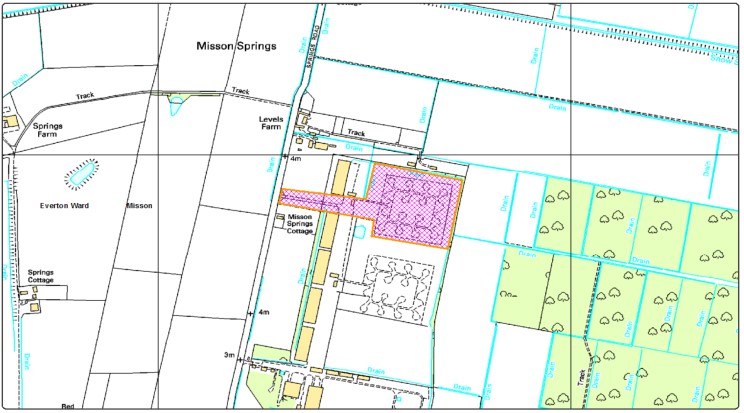
IGas has applied for planning permission for three years to drill one vertical and one horizontal shale gas exploration well at a site off Springs Road, in Misson. It has said it will not carry out hydraulic fracturing. IGas has said the main target is the Bowland Shale but it also sought to explore sandstones within the Millstone Grit Group and the Carboniferous Limestone Supergroup.
The vertical well would be up 3,500m deep. Well site construction is expected to last three months; drilling operations up to nine months and assessment of the wells another six months.
Drilling the wells, using a rig up to 60m high, would be 24-hours a day, seven days a week.
The proposed site is a former Ministry of Defence training and bombing site. It was used by the Bloodhound Missile surface-to air defence unit until 1963. It is 125m from Misson Car Nature Reserve, a Site of Special Scientific Interest. Misson village is 2.9km away and Finningley 2.8km. The nearest homes are 268m or more from the site.
What the planners said
Contaminated land
The planners’ report said the site could be contaminated by wartime munitions, chemical and/or biological contaminants or unexploded ordinance. But it said:
“These risks would need to be comprehensively explored by the developer and appropriate mitigation measures put in place to ensure that any risks to human health, environment, groundwater and property are eliminated and/or managed”.
Lighting
“The introduction of new lighting in an otherwise rural environment can quickly become a nuisance for residents”.
“The design of a detailed lighting scheme would seek to control obtrusive lighting, which would be used during hours of darkness for safety reasons, and lighting could be directed inwards and downwards and shrouded to minimise light spillage.”
Noise
“With the right mitigation measures in place, the changes in noise levels are likely to have a minor to moderate impact and would not seriously affect the quality of life given the short term nature of the proposed development.”
Air quality
“The overall impact of emissions and dust are unlikely to significant appropriate mitigation measures are in place given the relatively short term nature of the proposed development and the differing levels of activity during each phase of the development.”
Ecology
“There would be no significant effects on ecological receptors as a result of the construction, operation and decommissioning of the proposed development.”
Traffic
“A preferred HGV route has been identified to avoid HGV’s travelling through the village of Misson. The most intense period of activity would be during construction (phase 1) and restoration (phase 4) and there would be some improvement work required to the B1396 \ Springs Road junction.”
Landscape impact
“The development would not result in the loss of any landscape features although the drill rig would be the most obvious visual intrusion. However, the period of operation of the drill rig is short term, entirely reversible and therefore not considered to have a significant, permanent impact on visual amenity and therefore would not cause significant harm to the landscape or visual amenity.
The retention of vegetation and hedgerows on the site boundaries, and the existing warehouse buildings, would also offer some screening benefit to the development site.”
Planning policies
The planners said the following policies from the Bassetlaw Local Development Framework were relevant to the application.
Policy DM8: the historic environment shall be protected and enhanced to sure its long term future and that any development that would be detrimental to the significance of the heritage asset or its setting will not be supported.
DM9: new development proposals in and adjoining the countryside will be expected to be designed so as to be sensitive to their landscape setting
DM10: the Council will be supportive of proposals that seek to utilize renewable and low carbon energy to minimize CO2 emissions.
Policy DM12: all new development will be required to incorporate Sustainable Urban Drainage Systems (SuDS) and provide details of adoption, ongoing maintenance and management unless other key factors show them not to be technically feasible.
Councillors should also take into account Paragraph 135 of the National Planning Policy Framework, which said “a balanced judgement will be required having regard to the scale of any harm or loss and the significance of the heritage asset”.
The planners said:
“The proposal generally accords with existing planning policies and the Governments overarching support for the exploratory work needed to establish the potential for shale gas extraction. As such, it is considered that the principle of the proposed exploratory work is acceptable in this instance, as a purely exploratory operation.
“Fracturing is not a renewable energy but the Energy and Climate Change Secretary and Chancellor have both suggested that it can be seen as a low carbon “bridge” fuel in the transition towards a fully decarbonized energy system.”
Conditions
The planners recommended conditions covering contamination risks, lighting, environmental permits, traffic emissions, noise and vibration, site restoration, lorry routes and construction method statements.
Link to the planners’ report to Bassetlaw District Council (see pages 33-42)
What Professor Smythe said
Professor Smythe identified what he said were 27 substantive errors, omissions and misleading statements in the IGas application.
Fracking
Professor Smythe said the application was the first stage of what he called “an inevitable progression towards hydraulic fracturing of the Bowland shale”.
“The application is for unconventional shale gas appraisal, but has been disguised as a conventional exploration project by the addition of spurious secondary and tertiary hydrocarbon targets. A more transparent and honest application would have included the appraisal stage of fracking the horizontal well. There is no valid reason for this part of the work to have been omitted, other than a desire by the Applicant to get the first stage approved, in a salami-slicing subdivision of its unconventional shale gas development.”
“The geology of the UK shale basins is intrinsically unsuitable for fracking. No similar geology been fracked before. The USA experience is completely irrelevant. Fracking poses a direct threat to groundwater resources, and there is the possibility that fugitive methane may even reach the surface in a matter of days or weeks.”
Risks to water supplies
Professor Smythe said there was a possibility that principal aquifers in the Sherwood Sandstone and Magnesian limestone could be “contaminated irreversibly” by the development.
“The risk, however small, of permanently contaminating one of England’s main water resources should not be contemplated.”
“There is a myriad of potential contamination paths from the Bowland Shale, once fracked, to both principal aquifers. Even discounting major faults, the overburden itself largely comprises rocks that are highly transmissive.”
“In the Gainsborough Trough it is likely that some faults will leak fracking fluids and/or methane both to groundwater resources and to the biosphere; this is not a risk worth taking. No UK shale basin like the Gainsborough Trough has yet been fracked using horizontal wells.”
“No details whatsoever have been provide by the Applicant on how the two wells will be cased to mitigate contamination risk. In fact, it is not even clear whether the deeper portions of both wells will be cased at all. We have no clear idea, due to the inaccurate geological account provided by the Applicant, how deep each well will penetrate, and at what depth it will terminate. The provision of such information is normal practice.”
The site
“The Applicant has not demonstrated that the application site presents the best option in comparison with alternative sites within the area of search.”
“No satisfactory explanation has been supplied as to why the site was chosen. The explanation of how the search areas were defined is misleading. The primary shale target could have been selected from anywhere within the 182 km2 of the licence area available to the Applicant.”
“A 3D seismic survey has been acquired, but since the proposed drill site is very near its edge, the survey is inadequate for the required purpose of high-resolution imaging of layers and faults down to 2500 m depth.”
Misson Carr SSSI
“Given that the site lies just 125 m from the Misson Carr Nature Reserve, an SSSI, it is incumbent on the Applicant to show why, within the total PEDL area available of 182 km2 , no better site could have been selected.”
Horizontal well
“The shale will be unchanging in physical and hydrogeological properties along the kilometre or so of the horizontal path (unless an unforeseen fault is encountered), so there is no merit in drilling horizontally. All the required “evaluation” (appraisal) of the shale can be done from the samples taken from the vertical well, together with the appropriate electric logging.”
“There is no conceivable scientific or economic merit in drilling the horizontal well per se, because the shale cannot be exploited without fracking. In addition, the horizontal well cannot be classed as proving whether or not the hydrocarbon deposit exists, because we already know that it is there.”
“The Applicant is thus seeking to mislead the Council into believing that the horizontal well is a necessary part of the current work programme. In truth, it is superfluous, other than to prepare the way for high volume hydraulic fracturing, (‘fracking’). The Council therefore needs to seek clarification from the Applicant as to why the appraisal phase of the proposed horizontal well does not include fracking, and why it is justified at all.”
Faults
“There is ample evidence of faults, with throws of 20m and more in size, in and around the site. The Applicant’s assertion that no faulting is seen is unfounded. Moreover, there is a significant fault, the Misson Fault, running right through the site.”
Link to Professor David Smythe’s report
- Bassetlaw District Council’s planning committee meets on 16th December 2015 at 6.30pm at Worksop Town Hall, Queen’s Buildings, Potter Street, Worksop, Nottinghamshire S80 2AH
- The deadline for comments on the application is 23rd December 2015.
This report is part of DrillOrDrop’s Rig Watch project. Rig Watch receives funding from the Joseph Rowntree Reform Trust. More details here
Categories: Regulation


An excellent summary which should help our case.
David Larder
Chair Bassetlaw against fracking
Everything is in place, and looks fine, but no! Retired B and B owner, and ex geology prof nearly 20 years ago who has been exposed as a total fraud finds that its just all too risky! Well theres a shock!
See http://www.thetimes.co.uk/tto/environment/article4163950.ece
or http://www.dailymail.co.uk/news/article-2713509/Scientist-claims-fracking-dangerous-argues-against-drilling-applications-fraud-lied-credentials.html
This comment is from a highly capable researcher, into Smythes incompetence http://frackland.blogspot.co.uk/2013/09/professor-david-smythes-critique-of.html
Note the frackland blogspot finished 2014 when research pouring out of the US left all commenters with egg on their faces!
The Times is owned by Murdoch who with Cheney is being helped to preserve his oil wells in Syria by Cameron, and both Cheney and Murdoch are putting out contracts to frack the whole Israeli occupies regions of Syria….
Smyth is right in saying that the 2015 US reports from research into water contamination show that frack fluid (along with other naturally occurring chemicals and minerals and some unidentified noxious substances the fluid takers with it_) DOES flow into freshwater aquifers in shale areas, and that in thicker shale areas, as in the UK, this incidence of migration will escalate due to the way beds interlink. In fact the US report shows that even vertical drilling puts our water at danger, so we need to stop the march to fracking and see how far conventional drilling has contaminated water in those current and past UK areas around drill sites.
Engineers are NOT geophysicists, Smyth is, and Smyth keeps ahead of the game with updates from around the world. He hasn’t yet referred to Ingraffea, once a frack paid geologist, who now like Smyth, says it should be banned because of the danger to water and land.
Smyth doesn’t lie about his credentials, at least he is a geologist unlike those engineers pretending to be, and at least he did work for Glasgow, and he openly declares his Emeritus status.
However, even geology is a poorly developed science, and that is what is the complicating factor. Massive amounts of new understandings nullifying a priori knowledge now show that rolling out fracking in Europe and the small land mass of England is more dangerous than in the US. In addition we need to look again at the dangers of vertical drilling as massive contamination could now be in the making because of the poorly delivered a priori reporting.