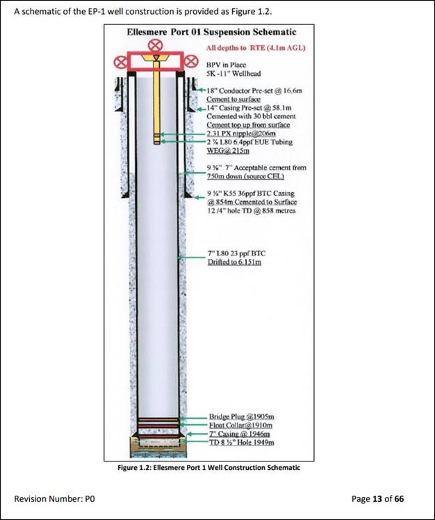
Diagram from IGas planning application to flow test the Ellesmere Port-1 well
Council officials are investigating how a gas well in Cheshire was drilled to a depth more than double that referred to in the planning consent.
Cheshire West and Chester Council said the IGas well at Ellesmere Port had planning approval to explore for coal bed methane at a depth of about 900m.
 But the company has confirmed that the well was drilled in 2014 to more than 1,900m.
The council, which issued the original planning permission, told DrillOrDrop today it had asked IGas to explain why it drilled to that depth and under what permission.
The cabinet member for environment, Cllr Karen Shore, (right) said the council had been investigating a “discrepancy between the depth of the well that had been approved and the actual depth drilled to by IGas”.
“As part of our investigations we requested further information from IGas and we’ve now received confirmation from their agent that they have drilled to a depth of 1,949 metres – more than 1,000 metres deeper than the planning approval allows.
“We have requested that IGas explain their actions and advise what confirmation they believe they had to drill to such a depth.
“We have contacted both the Health and Safety Executive and the Environment Agency to confirm that the relevant well audits, examinations and permits have considered such a depth. HSE have advised that their specialists are looking into it.
“Once we receive responses from IGas, the HSE and the EA we will consider what action we can take and seek further legal advice.”
IGas said this evening that the permitted well depth of 900m was a minimum, not a maximum.
But the company’s critics dismissed this, saying the planning application for the well clearly stated an average depth of 900m. Matt Bryan, a Labour councillor, on Cheshire West and Chester Council, said IGas had “no respect for democracy or planning law”.
The Environment Agency confirmed that IGas had complied with its environment permit on well depth. And the Health and Safety Executive told DrillOrDrop the depth of the well was consistent with the information from the operator before the well was drilled and in weekly reports during drilling.
But Colin Watson, Chair of Cheshire West and Chester Green Party, said the case showed that regulators do not work together. See more comments from IGas and its critics in the Comments section of this post.
1,000m+ disparity
The disparity over well depths came to light last month when IGas applied to Cheshire West and Chester Council (CWAC) for permission to carry out a flow test on the Ellesmere Port well.
The new application (17/03213/MIN), submitted to CWAC on 21 July, said the company wanted to test the Pentre Chert, a rock formation at a depth of 1,795m-1,849m.
The documents submitted with the new application included a diagram of the well, known as EP-1, which showed the total depth at 1,949m: more than double to depth referred to in the original application to drill the well.
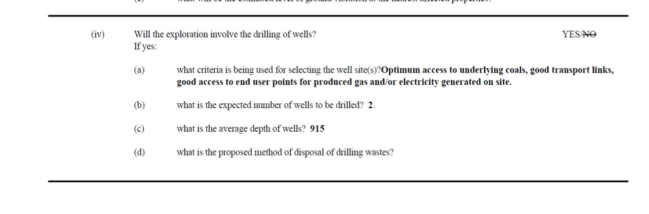
The original planning application (09/02169/MIN) was submitted in 2009 by Nexen, taken over by IGas in 2011. The application included a form which said the “average depth of wells” would be 915m (see below).
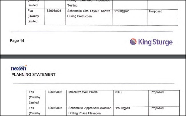
 A picture, called the indicative well profile, also included in the 2009 application, showed the well reaching a depth of about 900m.

Indicative well profile from 2009 planning application
This document was named in the company’s planning statement for the 2009 application, as Drawing No 62098/006.
A document with this number was listed in condition 3 of the CWAC decision notice, which granted planning permission in 2010.

Decision document granting planning permission for EP-1 well
Condition 3 said:
“The development hereby permitted shall be carried out in strict accordance with the following documents, except where these may be modified by the conditions below”.
There’s no reference in the conditions to any modification of the documents.
Coal bed methane or shale gas?
The confirmed well depth of EP-1 supports what IGas critics had suspected since the well was drilled in 2014.
As the company prepared to begin drilling in September 2014, the Chester Chronicle reported that IGas had permission for two boreholes to explore, appraise and produce coal bed methane at the Ellesmere Port site. But the paper said IGas was already describing it as a shale licence area.
After the well had been drilled, IGas told BBC NW News it had found 1,400ft (more than 425m) of shale. But the top of the Bowland Shale, at a depth of 1,725m, is about 600m below the bottom of the coal measures.
This is the second time IGas has drilled a well in the CWAC area deeper than that anticipated in the planning application.
At Ince Marshes, the company’s planning application said the depth of the permitted wells would be 762m. But the Oil & Gas Authority records the depth of the one well drilled in 2011 was 5,118.9 ft (1,560.2m).
When this emerged, geologist Kevin Walsh told the Chester Chronicle
“You cannot accidentally hit the shale gas as there is over 1,000ft of millstone grit below the CBM coal seams.”
Comments
IGas
A spokesperson for IGas told DrillOrDrop today:
“In 2014 we drilled a single vertical well to a depth of 1,945m below ground level, with the objective of appraising the geological sequence of the Ellesmere Port prospect, including the coal beds, consistent with the minimum depth of 900m stated within the planning statement and officers’ report.
“As set out in Section 9.3.6 of the Planning Statement Nexen October 2009, the appraisal boreholes would be drilled to an estimated minimum depth of 900m. The Planning Statement made no reference to the maximum depth of the boreholes.
“The well was also the subject of an application to the Environment Agency, under the Environmental Permitting (England and Wales) Regulations, within which we clearly set out the objectives of the well, in the context of depth.”
Politicians
 Cllr Matt Bryan, Cheshire West and Chester Council (right), criticised IGas’s record. He said:
“Sadly I predicted this would happen back in 2014 in the Chester Chronicle.
“IGas have been proven to have absolutely no respect for democracy, planning law or our natural environment.
“I expect residents will be unhappy to hear this latest sordid development and will make their views known in IGas’ latest planning application.
“IGas shouldn’t be allowed to run a bath let alone an operation to extract shale gas so close to a huge residential area, a Site of Special Scientific Interest and delicate petrochemical infrastructure.”
Colin Watson, chair of Cheshire West and Chester Green Party, said:
“This example shows how the regulatory bodies do not work together, since despite the Council’s overriding permission was for a depth of 900m, the EA’s environmental permit was for a well down to 2,100m.
“This lack of coordination between the regulatory bodies is becoming more and more apparent as government cuts reduce the size of departments to a level where they struggle to operate effectively.
“What is particularly concerning about this well is that it passes through a water course classified by the Environment Agency as a “major aquifer, high vulnerability”. If IGas cannot respect the Council, will they respect the aquifer?
“Also the well is 75m from industrial units, 200m from the M53 and 600m from houses; all within the impact zone of a major blowout if the American experience is anything to go by.
“The key message from this example is that once these companies get underground and you cannot see what they are doing, they will do anything!”
Regulators
A spokesperson for the Environment Agency said this evening:
“The Environment Agency is satisfied that IGas have complied with the conditions set out in their Environmental Permit.”
A spokesperson for the Health and Safety Executive (HSE) said:
“HSE is content that the requirements of the health and safety regulations were complied with and that the depth of the well is consistent with the information supplied in the notification provided, both before the well was drilled and in the weekly operations reports provided during drilling. Officials from Cheshire West and Chester council have been made aware of this.
“HSE will continue to work with other regulators and local authorities to regulate the onshore oil and gas industry in a robust and proportionate way.”
Links
The application to carry out flow testing at EP-1 is on the CWAC planning website: https://pa.cheshirewestandchester.gov.uk/online-applications/ use the reference 17/03213/MIN. The public consultation runs until 28 August 2017.
IGas Regulatory News Service notice on the planning application
Frack Free Dee comment on the application
Updated 16 August 2017 with comment from the Health and Safety Executive
Categories: Regulation


Oh dear Cindy! You will find just about every well ever drilled in UK goes through an aquifer-holy moly. Whether the aquifer is used to source water is another matter! I can dig in my garden and come to water, but a long way below that is (probably) oil, in my area. And a few miles from me they have drilled down pretty deep to access geothermal energy. Other areas, they sink huge great shafts miles deep through aquifers and bring up vast quantities of coal, but guess what-the tap water is not black! Or, perhaps we should all live near a gold mine, turn on our taps, and get rich.
That is because what they are seeking to find and extract is way BELOW aquifers, hence the control against contaminating the aquifer (the well is cased). Gas and oil are then drawn up to the surface encased, through whatever.
UK is not USA.
As does the London Underground, and the aquifer is used for water…
Grant-enjoyed your comment, but what is the connection to fracking?? I wonder who it is speculating??
This was an exploration well-so, they explored. Did they explore outside of their authority? Doesn’t look like it. In terms of depth, they drilled deeper than 900 metres, which was required. These comments would actually have more substance if they had drilled to 899 metres-which is pretty ridiculous.
I would have thought, for local disturbance, doing a thorough exploration job, as long as it conforms, and then removing the rig etc. is better than keep returning and doing a little bit more each time. No proof, as yet, they have not conformed to anything other than a few councillors opinions. That happens.
Martin, The original planning application and consent is crystal clear. At the exploration stage, COAL BED sampling was to be undertaken from 2 wells of an average depth of 915m.
This consent was flouted when IGas drilled right through the coal, then drilled right through a layer of hard Millstone Grit, and then carried on drilling in order to sample the shale at a depth of 1949m. IGas even proudly declared that they had found a 1400ft layer of shale on the local BBC news.
So again, the planning permission was to explore for Coal Bed Methane ONLY at an average depth of 915m.
This is just about as blatant a planning breach as you could ever wish to find.
Except the breach has no material impact, so almost certainly would have been agreed if applied for as a variation. Any attempt to require a retrospective application would be farcical (certainly not expedient). The planning officers report said a minimum of 900m. Combining an application for exploration with one for 25 years of production seems an error of judgement. Despite the application only talking about CBM by the time the test rig came on site the possibility of fracking was being widely talked about.
Which takes us into the realm of enforcement, proportionality and expediency which is a quite separate argument to the point I was making.
My point here is that there has clearly been a breach. I suspect, like you, that CWAC will decide that it is not expedient to take action but that shouldn’t mask the fact that shale exploration took place without IGas applying to vary the planning consent.
Yes, crystal clear -see page 2 http://194.187.35.179/Planning/lg/GFPlanningDocuments.page
Item 2.4 “minimum depth of 900m”
For balance this article could be written differently – e.g.. “Exploration well drilled to nearly 2km depth and nothing happened!!. Protestors and “anti-frack posturing” local politicians are most disappointed that their claims of environmental and infrastructure damage are unfounded”,. ,
Drilling to this depth is routine,, like hundreds of exploration wells, drilled, over many decades beneath the onshore UK
(As for an average estimated depth of 900m, I suppose a second well drilled to 1m depth will get that figure closer to that estimated average if one has to appease the scribes & pharisees).
It must be a first, to describe a chemical plant as delicate?
Grant-you state it is a blatant planning breach, but that is your judgement. It certainly is not the judgement from Igas or the EA. Certainly the former will have taken legal and technical advice. Maybe they have it wrong but dangerous to assume they have. Cllr Shore hasn’t and is seeking clarification. Perhaps she will take your word for it, but I doubt it. I am not too confident that drilling one deeper hole some years ago to acquire maximum data, rather than two shallower holes that might not achieve that objective, when there were no adverse effects, will be seen as any more than common sense. And reporting what they found at the full depth is a legal requirement of reporting to shareholders so not exactly proudly declaring anything.
But I quite understand the antis want to break their long losing streak, and any glimmer of hope is grasped.
The exploration phase “objective” as stated in the planning application was to extract coal samples for analysis. IGas decided that it had a new objective (i.e. to take samples of shale) that was completely absent from the planning consent.
The EA, as you are undoubtedly well aware, has no role whatsoever in relation to planning matters.
You are making it up as you go along Grant. You have no idea that Igas had decided upon a new objective, it could as easily be that they considered what they did as a natural extension of the objective ie. having drilled to the coal level to find more detail of what was below it in order to determine how and if, to optimise that coal strata safely. Then a minimum of 900 metres makes perfect sense. You are suggesting they started with other motivation-that is speculation. I should leave it to those concerned, some have decided to look at it objectively, others have decided to follow an activist agenda.
I am not familiar with this particular council, but wonder how many of these councillors were around at the time of drilling, and in what functions, or how many of the officers. Having had some experience of dealing with council/ planners (who often make mistakes-just look at legal costs against in most areas) that could be quite pertinent.
Much as I appreciate the work Ruth does to bring information to these pages, what she does bring, by definition, is what is available to be sourced. It does not mean it is the complete picture and making definitive judgements whilst those concerned are still awaiting feedback, as Ruth has pointed out herself, is like leaving a footy match with 30 minutes to go, the score is 0-0, and you have decided what the outcome will be. The score you predict may suit you but it is speculation and the probabilities are very much against it being the outcome.
Wow, that is quite a rant – I am not making anything up, have you seen the BBC coverage from 2014?
IGas openly declared that it was taking shale samples for analysis – this had absolutely nothing to optimising the coal strata safely.
“We actually found about 1400 feet of shale which had significant gas shows in it, which is actually very encouraging and exciting for us.”
John Blaymires, CEO, IGas
I’m not making that up.