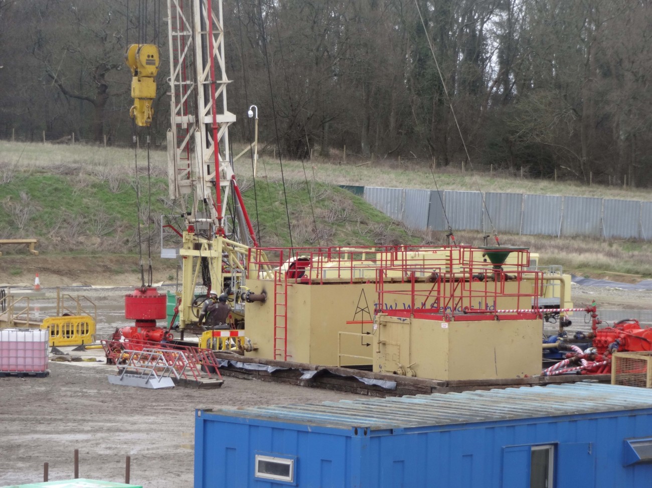
Flow testing at Horse Hill. Photo: Eddie Mitchell
In this guest post, David Smythe challenges the interpretation of faults around the Horse Hill “Gatwick Gusher” oil site in Surrey. He argues that the results of flow tests at the well can’t be applied to the whole of the Weald of southern England and predicts there will be no oil bonanza in the region without “wholesale fracking of horizontal wells”.
Introduction
For nearly three years, the press and the penny-investor bulletin boards have been excited by the alleged finding of a potential oilfield in the Weald Basin, bigger than the North Sea in oil content, below Surrey, Sussex, Kent and Hampshire. It started with the oil flow testing results reported from Horse Hill-1 (HH-1) – the so-called “Gatwick Gusher” – drilled by a partnership including UK Oil and Gas (UKOG) in the summer of 2014.
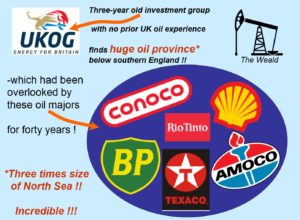 What is surprising is that the ‘discovery’ implies that the traditional oil majors (see diagram) somehow collectively failed to find this gigantic Weald reserve during their explorations in the 1980s.
As Euan Mearns, an experienced oil industry observer, put it in early 2016:
“How could we Brits be so dumb as to miss 100 billion barrels just waiting to be pumped from under the home counties?”
The majors drilled right through the Kimmeridgian; they tested it; they had the long-reach horizontal drilling technology (witness BP’s Wytch Farm development in Dorset and out under Bournemouth Bay – the biggest onshore oil field in Europe); so why did they all miss it? It seems to have been left to a small investment group UKOG, plus a few related minor hydrocarbon exploration companies, to unearth this bonanza.
All the current petroleum exploration and development licences (PEDLs) in the Weald issued by the Oil and Gas Authority are classified as ‘conventional’. That means no fracking and no large-scale acidising (another form of ‘stimulation’). So since fracking will not be used (they say), there is no new technology available to UKOG that was not already known to BP, Shell and the other majors in the 1980s.
I decided to look into the geology of the Horse Hill discovery, but didn’t realise until I started that I was opening a can of worms. The resulting technical analysis is here.
Magellan and UKOG at fault
Magellan Petroleum formerly had a stake in HH-1. The Magellan interpretation of the geology from 2009 was modified by UKOG after the results of HH-1 came in. But UKOG made the fundamental mistake of retaining the prior fault pattern instead of throwing it out and re-mapping the geology from scratch. The diagram below illustrates the error.

The UKOG faulting is in mauve and the corrected fault pattern in blue takes proper account of all the seismic data and the results of Horse Hill-1. Teeth mark the downthrown side of the faults (click to start).
Magellan had interpreted the geology as comprising a higher-standing block called a horst, bounded to the north and south by faults. It also said that the old BP well Collendean Farm-1 (CF-1), dating from 1964, lay off the edge of the horst block.
BP had drilled in the wrong place, according to Magellan. HH-1 was planned to be drilled into the horst block. The Top Portland Sandstone was predicted to be about 100 m shallower here than at CF-1. But it turned out to be 18 m deeper. In the light of this result UKOG produced a re-interpretation, while retaining two Magellan faults running ESE from CF-1 (mauve toothed lines). But the more southerly of these now has an alternating sense of displacement (the downthrow), which is geologically untenable except in certain geological terrains which do not apply here. Going from west to east, the fault downthrows to the south, then to the north, then back to the south again.
I re-examined the seismic data to see where the faults lie. My version is shown by the two blue toothed lines in the animation above. There is a southerly Horse Hill Fault running just north of HH-1, and dying out to the west. The crucial evidence comes from a vintage 1962 seismic line very near HH-1 which Magellan and UKOG omitted from their database. It is of poor quality, but does the job.
CF-1 lies just to the south of a mauve fault, and also just south of my blue Collendean Farm Fault. There is unfaulted geological continuity from CF-1, traced on seismic data round the west end of the Horse Hill Fault, then back east to HH-1. BP did not drill on the ‘wrong’ side of the fault. The seismic continuity of the nearly flat layers west of HH-1 fits perfectly with the fact that HH-1 is deeper than CF-1 by 18 m.
So the two blue faults of my remapping are parallel and distinct; they run ENE-WSW, following the regional pattern. UKOG has indeed made a minor discovery of conventional oil in the Portland Sandstone, but it will need to re-map the geological structure from scratch, to then explain to its investors whether or not it is worth exploiting commercially.
What of the huge Kimmeridge ‘discovery’?
UKOG leans on calculations made for it by Schlumberger, a respectable oil service company, who estimated that in the whole Kimmeridge Clay Formation there was 176 million barrels of oil in place per square mile based on the HH-1 results. UKOG further declares that this oil will be exploitable by a curious concept of multiple deviated wells from each pad. Its picture is shown at approximately the same scale as the Jonah Gas Field, Wyoming, below left, and expanded on the right.
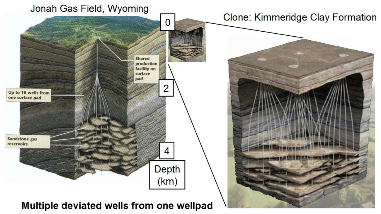
The UKOG deviated well concept for the Weald has been copied from the Jonah Gas Field, Wyoming
The giveaway in UKOG’s concept is their depiction of the Kimmeridge Clay Formation (KCF) as having a platy character, somewhat like a pile of overlapping chappaties. They appear to have borrowed the concept from the Jonah Gas Field, where tight sandstone lenses full of gas are exploited by multiple deviated wells.
The deviated Jonah wells are fracked to stimulate the gas flow. But this deviated well concept is useless for the KCF. Firstly, the scale is all wrong, because the KCF is 4-5 times shallower than the Wyoming sandstones, and secondly, the lens concept is completely inappropriate, since the KCF layers, in particular the limestone (micrite) layers, run laterally for 50-100 km without significant change. The tight KCF will require fracking of horizontal wells, drilled preferentially E-W, along the micrites.
As for the supposed huge reserve of KCF oil below the Weald; the oil in place has been estimated by Schlumberger on a per square mile basis. But how much area of a fractured fault zone can actually be drained from this single well? In addition, one certainly cannot extrapolate the fault zone flow results from HH-1 to the Weald generally. Using Schlumberger’s figure above, and a produceable reserve from the fractured tight KCF formation of 1% of the oil in place, HH-1 might be able, optimistically, to produce 177,000 barrels from the fault zone. In other words it might make enough to recover the costs of its exploration and development. This sort of figure might also be applicable along this and other fault zones.
Conclusion
The Gatwick Gusher’s results are anomalous because UKOG drilled a fault zone. It is irresponsible and misleading to apply those local flow results outside that and other similar fault zones, i.e in the 95% or more of the KCF which is not affected by a fault zone. There will be no KCF bonanza in the Weald – unless the countryside is indeed industrialised to permit wholesale fracking of horizontal wells throughout the region, with a 1-3 km well pad spacing similar to, say, NE Pennsylvania. But UKOG doesn’t want us to know that.
DrillOrDrop invited UKOG to respond to this Guest Post, which was first published on the Frackland blogsite on 26 August 2017.
DrillOrDrop welcomes guest posts. Please get in touch if you have an idea for a post or would like to respond to a report on the site.
Categories: Research


Poor attempt. Speculation regarding fracking, which is simply a continuation of this “experts” given opinion over a period of time, during which exploration has continued without any of the companies concerned indicating they have any need to operate fracking, based upon what they have recorded to date-at several sites, not just HH.
All companies involved in the current round of exploration have repeatedly stated that much more exploration and gathering of data is required before they know what the extent of this oil is and whether it is recoverable, and what methods would be most suitable-all of which would require authorisation to conduct. They are not responsible for investors, or press, extrapolating.
A “report” that is a composite of “mights” hardly qualifies as “technical analyses”.
With flow testing about to start at three other sites, it seems a strange time to be pre-empting actuals with mights. Too late to stop it happening but maybe just in time to scare some that much more invasive action will need to follow? A tactic that is becoming familiar.
It’s also a fairly weedy attempt to subconsciously associate the HH well to the Jonah Field, the aerial shots of which are the go-to file photograph for pretty much every scare story article in anti websites and literature.
Smythe certainly wins the prize for absolute dead certainty about his own infallibility when it comes to reinterpreting the geology. As a geologist I would look very dimly on any colleague who didn’t qualify their own personal unproven geological interpretation with “probably” “may indicate” and “it is possible that…”. We may draw our own conclusions when someone describes the work of several different company’s worth of geological departments as “how they’ve got the geology all wrong”.
But UKOG will no doubt be delighted that the Professor thinks 95% of the KCF is not affected by fault zones. What better news to hear when planning a horizontal or sub horizontal producer or two eh?
Balcombe 2z geosteered almost due West, horizontal, 1700ft along the 30m thick Kimmeridge middle micrite, which was found to be sufficiently naturally fractured to not require mechanical help. Another fault zone presumably? Smythe had, incidentally, stated quite categorically that that couldn’t be done successfully without 3D seismic. To say that there’s no new technology available to UKOG than was available in the 80s just underlines how out of touch this guy is. It’s like saying the cars and planes of today are the same as in the 80s. Anyone in the industry today would just laugh at that.
Theres no telling what final results will be after all the hoopla of penny share speculation and overenthusiastic press publicity dies down and real numbers come out. Smythe is right to warn of over optimism; Investor beware, but as you see from the last line, articles like this are concern trolling and disguised scare mongering.
The Jonah Gas Field, has some similarity to the Weald. It was a small company that managed to get the gas out and make money. But time will tell as to who is right no doubt.
Mr Collyer
Please first read my detailed analysis linked in the post above. Then come back with some reasoned comments – and technical errors, if you can find any. My analysis is restricted to what UKOG might be able to produce from the naturally fractured Horse Hill Fault zone, based on their flow tests. As such it is barely viable commercially. Why should I wait for “flow testing to start at three other sites”? I am commenting on UKOG’s results from Horse Hill: how they have got the geology all wrong, and what they are saying in spite of this about the future potential. This is not speculation, either by me or by other third parties.
What I object to is UKOG’s and others unjustified extrapolations from their atypical location to the entire Weald Kimmeridge Clay. However, I also gave due credit for their conventional discovery in the Portland Sandstone; however, they need to re-map it and come up with new reserve estimates.
Mr. Smythe, so, to summarize your argument, BP and other O&G companies lost out on this opportunity because they made a poor decision based on imperfect and incomplete information (how large the opportunity lost is subject to debate). You are now making an educated guess as to the level of productivity from the KCF based on imperfect and incomplete information, but you expect us to believe that your interpretation is “the correct one.”
Why is it that all of the geologists and petroleum engineers at BP are so poor at interpreting the data while you are so awesome?
My guess is that the folks within UKOG have access to data that is superior to that which you have viewed, and they are willing to commit capital to exploit the prospect. That piece of information carries more weight than your subjective interpretation in my estimation.
In addition, at the end of your diatribe you move from technical analysis to pure propaganda, rambling on about industrialization of the countryside and 1-3km spaced well pads. You do know that modern technology is allowing for much greater spacing, don’t you? Or do you not keep up with technological developments in the industry? I am also curious to know if you have a domestic solution to energy needs that can boast the same energy density as o&g and if so, what kind of industrialization of the countryside is involved in your proposed solution. Thanks!
…technical errors if you can find any…
OK. Your slide 2. “The closure area is based on just three 2D seismic lines shown in red”. If that’s the case, why doesn’t the closure extend much further to the east of line BP-85-75 ? Doesn’t the next seismic line also control limit of closure, as does the other N-S line on the west side (otherwise you could take closure against the fault much further west towards one of your red seimic lines)
Title – this is certainly not a “geological analysis” You do not mention porosity, permeability…
Maps – no contours on any of your maps, so impossible to make comments on your fault model without information about throw and heave.
Great debate and insightful comment from both side although I dont understand many of the technical terms used.
In my opinion David Smythe has let the UK down badly. He failed to find the oil in the 1970’s. We have failed to recover it when the price was high. He is objecting to planning applications so the flow tests won’t happen because it will prove how much he has cost the uk.
So when your benifits are cut. Council taxes rise. You have to pay for your parents care home costs. The Surrey fire control is overloaded. Remover David Smythe.
Hmmmm,
Do you think any of these may possibly of contributed to the rising costs of living ??
£850bn
http://www.independent.co.uk/news/uk/politics/163850bn-official-cost-of-the-bank-bailout-1833830.html
£37bn
https://www.google.co.uk/amp/s/amp.theguardian.com/world/2013/may/30/afghanistan-war-cost-britain-37bn-book
£9.6bn
http://www.independent.co.uk/news/uk/politics/chilcot-report-the-iraq-war-in-numbers-a7119336.html
£1.25bn
https://www.theguardian.com/news/datablog/2011/sep/26/uk-operations-libya-costs
£789m
https://en.m.wikipedia.org/wiki/Millennium_Dome
Jack
They have certainly contributed to our debt mountain.
One legacy we are handing over to our children, as well as 20% VAT. One day only a few old ones will remember the days when it was 12.5%.
Tony
David lives in France. To get a view on aging population and so on over there see what Bill Bonner is saying. Or try ‘ France is bleeding to death’ in moneyweek.
Lets see how much the UK tax payers would be shelling out each year in road damage from onshore fracking activities.
Lets compare the Cuadrilla vision of
” If Lancashire is commercial it will be the largest gas field in Western Europe. I think people need to understand the scale of it”
With a detailed report from NY
http://www.slideshare.net/MarcellusDN/draft-discussion-paper-transportation-impacts-of-potential-marcellus-shale-gas-development.
Bottom of page 7 gives basic idea of truck movements
Maybe the pro frackers would like to cough up the tens of millions it would cost annually to stop the road networks collapsing…..
I thought not.
Glad someone has mentioned care homes. A fracking industry would see the tax payer paying out millions to pay for elderly people going into full time care who do not have enough savings to pay for themselves. Why, because most people sell their homes to pay for care. As a wide scale fracking industry would devalue property, people will rely on the state sooner as their own funds will run out sooner. At around £30,000 per person per year the tax payer will be shelling out millions.
However Cuadrilla have stated that house prices will rise near fracking sites which sounds right as most people who move to the country prefer to purchase next to toxic, noisy industrial sites with relentless lorry movements than quiet rural areas with open countryside and sleepy village life.
The mind boggles
I have spoken with several geologists on the wider subject of ‘shale’ in the UK. The only thing that is consistent is the varied opinions from each.
Whilst speculation is important to a company’s share price it serves only as a short term factor, more important are facts. We will only know facts later down the line.
In the meantime I can only assume the naysayers have their own personal agenda as do the pros.
Oh and I am aware of the fact HH is conventional. I’m just making point about opinions.
David Smythe has slowed down the gas production in the UK , meaning more coal has been burnt.
John
Unfortunately, coal burn has dropped recently. Any shortfall in frack gas can be replaced by imports.
Lots of cheap coal available from Russia or America if we want it.
Obviously this is an exercise in subjectivity, otherwise BP would have gotten it right the first time. Data can be interpreted in many different ways, and often the most important data is that which is not gathered, meaning that opinions are highly speculative. When you mix highly speculative opinion with anti-frack activism, voila! You get a negative outlook for UK onshore oil and gas prospects. Next!
It is you David who is stating that HH results can not be applied to elsewhere in the Weald. As HH results are very early, and initial, and the other three sites I referred to in the Weald have yet to complete any flow tests, this is not science or any type of technical analyses I am familiar with. It is simply your opinion without anyway near a full set of data. In other words-a guess. And that choice of terminology is very kind, and suggests the real can of worms.
UKOG have not extrapolated HH to the rest of the Weald. They have made it quite clear how much extra drilling and testing could be needed to show that.You know where the extrapolation has come from but you persist with these statements to support your position. Technical analyses? Err, no.
Omnibus reply
Not one of the dozen or more comments so far has disproved (or even tried to disprove) my analysis showing that the current UKOG geological interpretation is untenable. Instead we have the usual pro-fracking trolls, who, for want of proper technical debate, attack my integrity, expertise, and so on. One of them, Mr Decker, even claims to be a geologist. I’ll comment on just a few specific points here.
Jonah Gas Field
This is an unconventional tight gas sandstone in a conventional structure (an anticline) which has to be fracked to extract the gas. The wells are vertical in the sandstone, deviating from multi-well pads. It has no geological similarity whatsoever to the Kimmeridge, hewes62. None of you has questioned why UKOG is proposing such a well geometry for the Kimmeridge. I did not suggest the Weald-Jonah link, Mr Decker – it was UKOG that did, with its Jonah-like well concept.
Magellan seismic interpretation pre-Horse Hill-1
The actual closure is defined by just three seismic lines as highlighted by Magellan. Of course the regional structure is defined by several more lines, perhaps a dozen in total. What point are you trying to make, Mr AI? Is that the best you can do to discover a supposed technical error of mine? Do you not agree that the Magellan mapping is now completely obsolete, following the drilling of HH-1? And if so, what about UKOG’s dog’s dinner remap?
It is not my job to remap the whole area; that is why I have not supplied a new contour structure map, which would take months of work; I have simply done sufficient to demonstrate that the current UKOG fault scheme and well-tie, post-HH-1, is untenable.
Extrapolation of HH-1 results to the wider Weald
It is not I who has extrapolated the results, neither is it the press or investor discussion sites. It is UKOG themselves. See, for example, their ‘UKOG Master Investor Presentation’ dated 25 April 2016. Slide 11 is headed ‘WEALD BASIN: CALCULATED OIL IN GROUND, post HH-1’, with labels pointing to ‘Horse Hill licences (1 billion barrels)’ and ‘Total Weald (19.5 billion barrels)’ of oil in place. This slide is sandwiched between one titled ‘HH-1 OIL DISCOVERY 2014’ and another titled ‘GATWICK GUSHER FLOW TEST’. So unless UKOG have confidential access to several more well flow tests that they are not telling us about, this is extrapolation, pure and simple, by them, from their one well.
Old technology, old data
You completely misunderstand my reference to the majors who explored the Weald in the 1980s, ‘protectthis’. BP and the others did not “lose out” or make a “poor decision”. Their staff were not “poor at interpreting the data”. You attribute to me statements I did not make. They made the correct decisions for the time. They could drill deviated and horizontal wells back then. The available technology would have been more expensive than today, of course, but then the oil price was higher to compensate (at least till 1986). That is why I am surprised that UKOG are claiming to have found something missed by all the majors.
You also guess that the “folks” at UKOG have access to “superior” data. Nonsense – they are using the same old seismic from the 1970s up to 1990, some of it reprocessed. You can see the lines on their interpretation, shown in my slide 6. Pity they forgot to include the 1962 Esso lines (my slide 14)! Reprocessing, something I used to specialise in doing for my clients in the Wessex Basin and elsewhere, can be a double-edged sword, best used to ‘stress-test’ a doubtful structure or correlation. Their reprocessed migrated version of C80-130 (my slide 8) was a marginal improvement on the original (my slide 10), but didn’t prevent them making a pig’s ear of the correlations across the fault zone.
UKOG are using the same old IHS Kingdom seismic interpretation and contouring package which has been around for years (I have a loan licence myself). So, in short, UKOG are not doing anything revolutionary or new.
Conclusions
From the comments to date I don’t see any reasoned refutations of any part of my analysis of Horse Hill. I won’t bother responding to future comments unless such a properly-founded criticism does emerge – but it’s unlikely.
David
Thanks. Similarities re the geology I would leave with the geologists. My point was that a small company made the Jonah field a success. Maybe a small company will make the Weald a success, or maybe not. Time will tell.
As I stated up thread, your document is not a “geological analysis”. You could call it a “fault analysis” or “structural analysis” but that is being generous as you do not show any contours. Months of work to reinterpret and depth convert a dozen seismic lines??? I wish I worked as a consultant geophysicist!