
Location of proposed sites at Ince Marshes. Source: British Geological Survey
Proposals for an underground observatory in north Cheshire, predicted to provide the “most comprehensive geological data” in the world, have been published online and are open for comments.
The details are in a planning application by the British Geological Survey (BGS) for a Geoenergy Observatory at Ince Marshes. If approved, it would see 50 monitoring boreholes drilled to a depth of 50m-1,200m across 14 sites.
According to the BGS, the observatory would improve understanding of
“the nature, extent, accessibility and sustainability of some of the UK’s substantial and widespread geological resources”.
The proposal has prompted concerns by some anti-fracking campaigners that the observatory would facilitate fracking for shale gas and risk environmental damage. The observatory is in the same area that the exploration company, IGas, is preparing an application for fracking.
The BGS said there would be no exploration or extraction of minerals or conventional gas and the proposal was independent of the shale operators. It would also not involve drilling into the Bowland shale. The application said:
“The proposal is purely to enable the study of the physical, chemical and mechanical properties of the underground environment and to observe the effects of human and natural change on the subsurface environment.
“The observatory will provide impartial, independent and trusted data for all”.
The proposal is one of two sub-surface research test facilities in the UK. The other would be in Glasgow. The Cheshire site would be funded by £31m from the Department of Business, Energy and Industrial Strategy allocated to the Natural Environment Research Council.
The application comprises 43 documents, including a 110-page planning statement and a 150-page non-technical summary of an environment assessment.
A formal public consultation or deadline for comments has not yet been announced. This post will be updated with details when they are available.
DrillOrDrop has compiled key details from the proposal. We will follow the application through the planning system and report on reaction to it.
Key facts
Description: Creation of a geological research facility with 50 monitoring boreholes across 14 sites (called Sites A-N), plus a central telemetry mast, with monitoring equipment, in-field data centre, access tracks, telemetry and fencing.
Application reference and online link: 18/04894/FUL
Applicant: British Geological Survey
Decision-maker: Cheshire West and Chester Council
Dates: Submitted 21 December 2018; details published online 9 January 2019; expiry date for neighbour consultation 30 January 2019
Location: Ince Marshes, between Mersey Estuary, Stanlow refinery and the village of Helsby. 11km north east of Chester, 150m from the Manchester Ship Canal, crossed by the M56 motorway, A5117 road and Helsby-Ellesmere Port railway line.
Purpose: The boreholes would contain instruments to observe and monitor the subsurface environment. The aim is to improve understanding of “the nature, extent, accessibility and sustainability of some of the UK’s substantial and widespread geological resources”.
Justification: “ to create a new world class research facility in Cheshire”… “the research provided …could then help to underpin policy making and inform future decisions on the future energy mix”.
Duration of permission sought: 20 years
Geology: near surface bedrock is Sherwood Sandstone, a principal aquifer
Landscape: low-lying land with ditches draining to the River Gowy and River Mersey
Size and location
Size: 7ha, about 3km wide and 4km long, comprising 14 discrete locations.
Villages included in the application area: Elton, Thornton-le-Moors, Ince and Hapsford are all in the 7km area. Helsby is 1.7km to the south east and Ellesmere Port is 6km to the west of the application area.
Employers in the application area: Stanlow Refinery, Thornton Science Park, Encirc Glass Factory, CFF Fertiliser Factory
Greenbelt: 10 of the sites (A, B, E, F, G, H, I, K, M, N) are in the defined North Cheshire Green Belt. All but site A, would have ground water or seismic monitoring cabinets. The BGS said: “it is considered that the proposed development will not interfere visually or other wise with the openness of the Green Belt”. The BGS added that if the development were considered inappropriate for the Green Belt it could be justified because the scheme was essential and had national government support.
Habitat loss: The scheme would involve the removal of about 135m of hedgerow. There would also be a loss of grassland or scrub woodland at nine sites and a loss of coastal and floodplain grazing at one. Site N was said to be used by lapwing and marsh harriers.
Boreholes and telemetry site
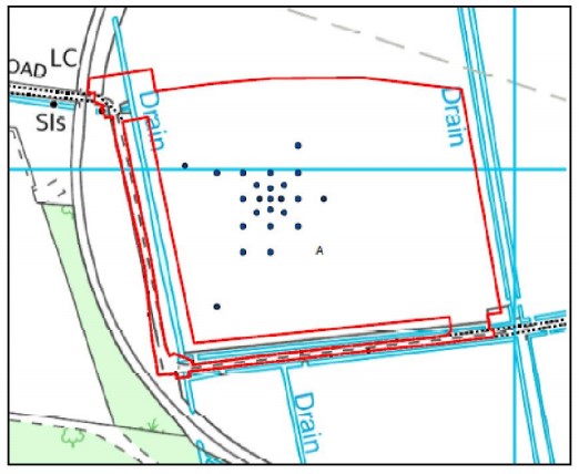
Proposed site A at Ince Marshes. Source: British Geological Survey application
Boreholes depths and numbers: If approved, the observatory would drill 50 boreholes to depths of: 50m (x16); 100m (x20); 200m (x7); 300m (x3); 600m (x3); and 1,200m (x1). The boreholes would include 1,800 scientific sensors.
Borehole locations: Site A, called the inner array, would have 24 boreholes: 50m (x8); 100m (x12); 600m (x3); 1,200m (x1). This is where the research would be undertaken. Sites B-N, called the outer array, would have another 26 boreholes, ranging from 1-3 per site, drilled to a depth of 50m-300m. The outer array would be used for seismic and groundwater monitoring.
The telemetry site, west of Site A in Thornton Science Park, would be the central data gathering and distribution centre.
Work phases
Construction: This comprises site clearance, road improvements, erection of security fencing and temporary structures; drilling boreholes and installing instruments; installing surface cabinets and more security fencing. If approved, construction work would be from mid-2019 to autumn 2020. The boreholes would be drilled 24 hours a day, seven days a week. Total duration of drilling is estimated at 135 days. The 1,200m borehole – to be drilled into the Millstone Grit – is expected to take 90 days (or 75 days, according to the non-technical summary) and the 600m boreholes 40 days. During drilling there would be hydraulic tests, geophysical logging and microbiological sampling. The main purpose of the 1,200m borehole was to provide a stratigraphic record of the geology and to monitor seismic activity and temperature, the application said. Drilling of boreholes in the outer array is expected to take an average of 14-28 days per site. These boreholes would be used for research on groundwater flows.
Operations: 15 years of geological research on
- baseline environmental conditions, including groundwater, rock character and geochemistry
- sub-surface imagery on the physical properties of rocks; flow, chemistry and temperature of groundwater; monitoring air quality, tilt and movement underground, and behaviour of subsurface microorganisms
The BGS said researchers would visit regularly to sample groundwater, run research and maintain equipment. Many sites would be monitored remotely. It added:
“It is anticipated that researchers will be able to apply to use the site in order to undertake specific research under licence.”
Decommissioning: Restored to existing condition, including capping the boreholes and removal of all surface developments
Need for the proposal
The BGS said:
“A range of energy resources, infrastructures and technologies are likely to be required as part of the UK’s transition to a low carbon energy system. Many of these resources are likely to have impacts on, or implications for, the subsurface.
“There is a need to develop low carbon alternatives that are safe, reliable and affordable and it is vital to understand what the potential solutions are, how they can be done safely, and how they can be implemented without impacting upon the environment.”
The BGS said it sought to answer four questions:
- Can we improve our ability to picture and image the underground without drilling into it?
- Can we understand better how liquids and gas move through rocks and fractures underground?
- Can we understand better how the physical nature of rocks in the underground might change as their environment changes?
- Can we understand the biological character of the underground and how it might change with the changing environment?
The application said data would be streamed in real time and would be open, free and accessible through an online portal. It would provide data on rock properties, air quality monitoring and local effects of weather on air quality.
Public consultation
The BGS said it had “undertaken a comprehensive programme of community consultation which has involved engagement with Cheshire residents, businesses, decision-makers, policy-makers, educators and elected members.”
These included community drop-in meetings in six surrounding towns and villages in 2017. A further meeting was held in Elton in September 2018. Information packs were sent to 10,500 households. The BGS said it had also consulted with local businesses and organisations, including RSPB, Cheshire Wildlife Trust, owl and badger groups.
Environmental assessment
The application includes a four-volume environmental statement, including a non-technical statement. This concludes that for all the sites in the Green Belt were considered to have a “limited and temporary impact”.
The BGS said the proposals complied with the local development plan, as well as national planning and energy policies.
It concluded that with any necessary mitigation there would be no residual effects or no significant residual effects on landscape, visual amenity, biodiversity, cultural heritage, air quality, noise levels, surface water quality, food risk, people and communities, climate change,
On traffic, there would be a minor adverse effect near seven sites (A, C, F, H K, L and N) but the effects would be short-term during construction. No residual effects were anticipated at the remaining sites, the BGS said.
The assessment identified risks of contamination to ground and surface water from drilling, particularly at three sites. Mitigation measures would ensure there would be “no significant residual effects” during construction and decommissioning. The Environment Agency would be consulted on operational activities, the BGS said.
There would be a negligible effect on landfill and a minor adverse effect on recycling and water treatment facilities, the BGS said.
Drilling could affect supply pipelines to the CF Fertiliser Factory and the Stanlow Refinery. But the BGS concluded that with mitigation measures in place, the development would not alter the likelihood of a major accident.
Alternative sites
The BGS said:
“The rock layers, structures, available data, and factors in the Ince Marshes area including the Science Corridor together provide a combination that cannot be found elsewhere in the UK.”
Site A was selected because it is close to the important Dungeon Banks fault, the BGS said.
Categories: Regulation


How long before we see a comment from a regular poetry poster and IC fan about nuclear waste disposal research?
Looks like a great BGS project; antis and pros alike should support this….
Oops! Pauls Own Mindset Alert!
Dear me! Manners Paul! Its a bit early in the game to get so upset so quickly isnt it?
Do try to get a grip old thing, such a display is only showing up just how your own mind works, not mine or anyone else’s, these little examples just go to show how true that is.
If you are so far reduced to such super sensitivities’ about the high level radioactive nuclear waste issue, then preempting the issue like this only shows a worrying sensitivity to the subject? Which is frankly a bit revealing isnt it?
Actually I had no intention of raising any such issue reading the above, but congratulations on revealing your own suspicions about all that, maybe you know something we don’t?
Do tell?
I see also your frankly flattering obsessions with myself and…..i presume you are referring to Ian R Crane, but apparently you cant bring yourself to write his name correctly for fear of raising that scary specter in your own internal infernal mindset…..? I would worry about that if I were you? Yes, sends a shiver up my spine too!
And I so appreciate all this attention you give to the poetry and songs, not mine mostly I hasten to say, but it kind of gladdens the heart to see how it has such a beneficial effect on lives so starved of any sort of culture other than their own dismal boring internal fossilised monologue?
I am glad to be of service old chap, any time, you only need to ask?
And as for the general tone of your comment, we were just talking about just how far the PR hotdesker recidivists have descended into bitterness and bile, rather than actually discussing anything like professional adults any more, and here you are amply displaying all of your own volition just how true that is?
Congratulations! You prove my point with such a willing example! I couldn’t have asked for a better illustration?
Thank you.
Quod et demonstrandam indeed!
The industry really must be desperate to sink so low so quickly……Ha! Ha! Joke!
The mere fact that you needed to raise the high level nuclear waste issue is actually more telling of your own suspicious mindset on that issue than anyone else’s BTW. But of course you know that dont you?
Apparently you guys are so super sensitive to the nuclear waste issue, that maybe you suspect something is going on with that in this report do you?
How interesting?
Do tell?
What’s the time, oh just gone 0400, I must finish this report and get home for a well deserved rest.
Such fun!
Always a pleasure!
Have a nice day!
How can they claim that this research centre is intended to explore “the nature, extent, accessibility and sustainability of some of the UK’s substantial and widespread geological resources” and then claim it isn’t about fracking. Perhaps the people at BGS can expand on this by explaining what other geological resources they are thinking of in a PEDL area owned by iGas. But of course they are “impartial, independent and trusted” and not funded by the pro-fracking UK government. Oh, wait …
The sole reason for this research centre seems to be about how we can better exploit hydrocarbons stored underground. However, we know that we are barrelling towards a climate catastrophe and should leave most of the hydrocarbons already identified underground if we are to prevent runaway climate change. What possible good could a research facility that aims to make this easier?
https://www.gov.uk/government/news/geological-disposal-understanding-our-work
‘…..a site will only be taken forward if the Community supports it”
Really, like we support fracking the Fylde and building housing projects all over Wrea Green and Warton countryside and farmland?
This report was dated 2016 so an update would be most interesting after all the Community protests in fracking locations Countrywide and in the Courts of Appeal etc.
Ellie this is a scientific establishment. Its designed to investigate and understand the earth for every possible reason. The reason that we know about the climate change is from this level of scientific reseach in numerous branches of earth science. Yes it may inform decision making about fracking, (one way OR the other) but it also feeds into the entire geological field of earth science knowledge.
Your paranoid view is just the kind of anti-science, (literal in this case,) pitchfork waving yokel that plagues these discussions. You can have no concept of the research that will stem from this centre and yet you have already objected to it on your spurious argument.
Also you do the science staff of the BGS an enormous disservice by basically calling them liars. They are for the most part scientists at the pinnacle of national research and their published work is subject to peer review across the world. You may not understand what that means, but their scientific credibility rests on that. To have such a reseach facility is an enormously prestigious thing for the whole country not just the local area and you cannot think outside your own personal hangups.
Well said MD.
“Salt of the earth” Ellie.
Cheshire.
Simples.
Or, even, perhaps-water. Or, even, perhaps- geothermal. And on and on.
Not so exciting, but equally valid.
Ruth
Your report says that the Research Centre is in an area where “ IGas is preparing an application for fracking”.
Is that correct? In their Statement of Case they say that no fracking is involved. So would it not be correct to say that the Research Centre is in an area where ‘no fracking is planned’? Or in an area where some people believe fracking is planned?
Has their position changed?
Click to access igas-statement-of-case-ellesmere-port-with-appendicies.pdf
Hi Hewes62 Thanks for your comment. You’re quite right that IGas said it would not frack at Ellesmere Port. The company’s plans for Ince Marshes are, however, different from the Ellesmere Port scheme, at a different location. The company issued a trading update (link here: http://www.lse.co.uk/share-regulatory-news.asp?shareprice=IGAS&ArticleCode=jfppewpr&ArticleHeadline=Trading_Update) in August 2018 which said: “Ince Marshes application- whilst the application is now complete, we have taken the decision not to submit to Cheshire West and Chester Council until the outcome of the Ellesmere Port appeal is known.” For confirmation on IGas plans to frack on the Ince Marshes, see the full year results from March 2018: http://www.lse.co.uk/share-regulatory-news.asp?shareprice=IGAS&ArticleCode=dsa3zy80&ArticleHeadline=Full_year_Results Hope that helps. Best wishes, Ruth
Ruth
Thanks for the reply.