
Stuart Haszeldine, Professor of Geology at the University of Edinburgh, reviews new research on fracking-induced earthquakes, released yesterday by the Oil & Gas Authority. The studies analysed hydraulic fracturing at Cuadrilla’s Preston New Road shale gas site near Blackpool and concluded that induced seismicity was difficult to predict and to manage.
Geology
The rocks which make up the upper earth, or colloquially the ground we live on, are in a fine balance of being pushed forwards, shoved sideways, pushed up, or loaded down.
These movements are consequences of forces and loads sometimes imposed from hundreds of kilometres distance; but the effects of those forces are the stresses held in rocks for thousands, and even millions, of years.
Occasionally through geological time, those forces combine in a direction and a magnitude to fracture the rock. Or more commonly to reactivate movement along pre-existing fractures and faults. This is one way of producing earthquakes – which in the UK can sometimes be felt at the surface as ground movement. Very rarely in the UK, earthquakes release enough energy from the stored rock stresses to cause movement and damage at the surface. But much more frequently the earthquakes of lesser energy – hundreds of thousands every year – have no effect on surface dwellers and can only be detected instrumentally.
The purpose of high fluid-volume fracking is to artificially engineer injection of fluid into a borehole, such that the rock is quickly stressed during tens of minutes, to produce artificial fractures.
Inevitably the threshold of additional stress to create those induced fractures will be influenced by the stresses already held in the rock, and the location of fractures and movement will be influenced by pre-existing fracture locations and directions in the rock.
In the UK there are many thousands of pre-existing faults, and the complex ancient and recent geological history makes it extremely difficult to locate all the faults and fractures, and makes it almost impossible to accurately predict the stress imposed on each fracture or fault.
Thus, the effects of human intervention are hard to determine in advance, and even if an earthquake occurs, it can often be difficult to assign that effect to the cause of nearby human activity.
The HiQuake database (www. inducedearthquakes.org) has compiled many of the earthquakes suspected of being linked to human activity and lists 1196 events since 1868, of which 33% are associated with fracking, whilst acknowledging that the smallest events are the least well reported. For all these reasons, the association of earthquakes with stress caused by fracking is very contentious and will undoubtedly remain debated for years to come.
Lancashire shale gas
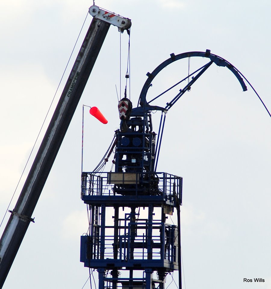
Preston New Road 1 and 2 wells, as well as Preese Hall also in Lancashire, are well known as deviated boreholes, where high volume fracking was attempted.
At Preese Hall in 2011, there is no doubt that fracking produced a small earthquake, which was recorded by seismometers, was felt locally, and reactivated a small fracture to move several centimetres – cutting through the borehole.
PNR1Z well at Preston New Road Upper Bowland Shale
After five years of review, hydraulic fracturing operations were attempted by Cuadrilla Resources on the PNR1Z well at Preston New Road in autumn 2018. Much more strict regulations were imposed by Government, meaning that fracking fluid water volumes were smaller and that fluid pressures during operations would be smaller. And a Traffic Light System was instigated, to halt work if tremors exceeded a pre-determined Magnitude.
The site was also instrumented a lot more intensively, because detection of small earth tremors, containing very little energy, needs to be close to the source. This is in a similar way to how humans hear sounds much louder close to the source, but the sound is fainter when distant from the source.
The information collected during those attempts at closely supervised fracking was released by Westminster government’s Department of Energy (BEIS) to its regulator, the Oil and Gas Authority (OGA).
During 2019, the OGA arranged for three different and independent scientific groups to undertake paid analyses of four different aspects of this information. These projects were continued to include analysis of additional information from PNR2 hydraulic fractures.
PNR2 well at Preston New Road, Upper Bowland Shale, 200m shallower than PNR1
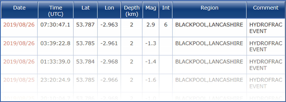
This well was drilled, and then after PNR1 in 2018, was fractured during late 2019. The seismicity was closely monitored and pauses introduced after larger tremors, and the injection of fracking fluid limited to sub-economic volumes. Even with these precautions the fracking was terminated on 26 August 2019, after an earthquake of 2.9 ML.
In March 2020, the OGA continued the four existing studies from PNR1 to include study of seismicity resulting from the PNR2 hydraulic fracturing operations. These are:
- Geo-mechanical properties of the rocks by Outer Limits Geophysics
- Compare the measured surface Magnitude ML with the recorded subsurface moment Magnitude Mw undertaken by the British Geological Survey (BGS)
- Intraseis Ltd to analyse and predict the surface impacts caused by ground motion following earth tremors or earthquakes
- BGS to investigate aftershock tremors following an individual triggered earthquake
Results
The analysis and interpretation from both PNR1 and PNR2 boreholes has now been compiled and interpreted to provide conclusions.
These detailed studies were only possible because of the much larger data sets of measurement available. That followed specific regulatory requirements for these two boreholes which ensured surface and downhole microseismic measurements, coincident in time with operational datasets for fracking fluid pumping volumes, pressures and other borehole logging data such as 3D location of microfractures.
Even with these multiple and local instruments – several more than any other UK site – the interpretation is not at all simple, or predictive.
• The Geo-mechanics analysis concluded that multiple mechanisms exist which could cause the larger felt earthquakes, and no simple single cause could be identified.
• The Magnitude comparisons found that the two boreholes produced different results, so no simple prediction can be made of surface effects.
• The surface impacts study successfully modelled a 16x15km zone around a simulated earthquake. Damage to 52 buildings occurred by comparing to the recorded 2.9ML event. Following an “unlikely” 4.5ML event, abundant damage to buildings would occur within a 1km radius with lesser damage within a 4km radius. In such a case, the borehole itself would not inevitably be damaged. [Although that assumes that no fault or facture intersected the borehole – as it did with Preece Hall]
• The aftershocks could not be predicted with certainty, although there is a correlation with volume of fracking fluid injected.
• The detailed 3-D tracking of fracture growth in real time from the borehole, induced by fracking, had no correlation between the two boreholes, even though those are closely spaced in similar rock units
• Fracking of PNR1 detected a previously unknown fault, which is not geographically oriented to slip easily in alignment with pre-existing stress in the rock
• Fracking of PNR2 also detected a previously unknown fault, which is well oriented to slip in the pre-existing stress in the rock – and this fault produced a 2.9ML event.
What does this mean?
These two boreholes have enabled the gathering of a huge quantity of detailed data during fracking and earthquakes. The cost of obtaining this data and its analysis was speculatively at least £ 10M per borehole. That is beyond normal budgets for government research funds. Unless new developers emerge who are willing to challenge the de facto bans or planning prejudice against fracking across the UK, it is unlikely that any more detailed scientific work on fracking and seismicity is planned in the UK.
Even the abundant and detailed data from these two boreholes does not improve answers to the questions such as:
“does this borehole intersect a fault?” – both of the PNR boreholes discovered new faults
“what is the limit a borehole frack pressure can reach?” – the two boreholes achieved very different fracture directions at different fluid pressures
“how will the first borehole influence subsequent boreholes?” – the second PNR borehole produced greater seismic effects than the first
Neither does this study provide significant data to help developers identify which parts of the UK may be better, or worse, suited to attempted development by fracking.
The complexity of UK geology is a profound obstacle to precise geological appraisal of fracking developments, which must include:
- technical excellence such as precise 3D mapping of faults
- accurate stratigraphy of rock layering with fold and fault structure
- excellent understanding of rock geomechanical properties, including residual stress direction and amount – rock layer by rock layer.
One OGA recommendation for any future instrumentation of fracking is that a denser network of (shallow borehole) sensors should be used to improve event detection, given the limited (in)completeness of surface catalogues in the UK. Geophone detectors (like microphones) need to be installed down shallow boreholes to detect small tremors. And a more abundant array of surface geophones is needed to detect larger earthquakes. Meaning that developers will need to work significantly harder.
Conclusion
A final conclusion derived from OGA’s funding of scientific analysis is that there are no simple results from these studies.
So, high quality prediction of earthquakes or tremors probability or magnitude resulting from fracking is not currently possible in this region.
Significant damage to surface buildings could result from an unlikely earthquake event, which it is not possible to exclude.


(continued)
Thank you for the information concerning Equinor, Hewes62. This looks interesting.
Rough gas field was UK’s largest gas storage facility. It was decommissioned in 2017. This was a producing gas field prior to storage conversion.
http://www.offshore-energy.biz/centrica-to-close-uks-largest-gas-storage-facility/
No reason why CO2 couldn’t have been stored in the reservoir – getting it to the platform and into the reservoir (corrosion) would have been the challenge. Hydrogen – not sure – smaller molecules?
Most of the depleted southern north sea gas fields are suitable for C)2 storage – the challenge is the transportation and injection.
[Image removed due to copyright concerns]
A question I have not found answered is, “How much fluid escaped into faults from the injection and where has it ended up?”
I believe there are data concerning the amount of fluid injected, and the amount recovered, st. In addition, there are also data regarding the way such fluids would degrade within the ground, if they did remain there.
No different to the mechanisms that enable utilisation of products to clean patios, except none of those are usually recovered-so, keep them away from your plants !