Preston New Road shale gas site, 25 October 2017. Photo: Used with the owner’s permission
The shale gas company, Cuadrilla, has applied to dispose of water which collects on its fracking site near Blackpool into a brook instead of removing it by tanker.
The proposal, made in a 23-document application to the Environment Agency published yesterday, is another variation of the company’s permit for the Preston New Road site.
Earlier this week Cuadrilla was allowed to change environmental controls on issues including seismic monitoring, duration of flaring and the daily maximum use of hydraulic fracturing fluid. DrillOrDrop report
The new change, now open for a public consultation until 26 January 2018, is to pipe uncontaminated surface water into the nearby Carr Bridge Brook and install a treatment plant at the shale gas site.
Frack Free Lancashire said it was disappointed that Cuadrilla appeared to be able to “move the regulatory goalposts at will”.
People have already opposed the move by objecting through the Environment Agency’s consultation webpage. One person said:
“This is an exact example of how opening the door to Cuadrilla enables a foot in the door and tiny tweaks and variations overtime considerably change the application that was first permitted.”
Details
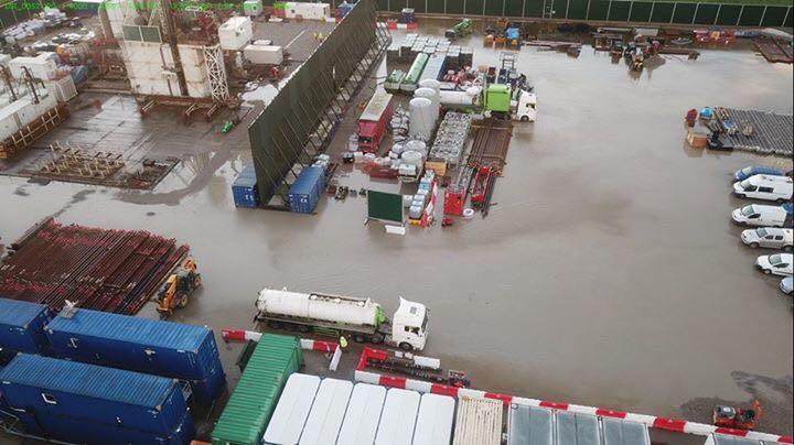
Several times this year there has been surface water flooding at the site. In April 2017, the Environment Agency told Cuadrilla to improve its surface water management after it breached the permit conditions by allowing water from the site to reach a tributary of the Carr Bridge Brook. DrillOrDrop report

Stack of drill pipe. The pipes are connected together and fed down the well as drilling proceeds. Once drilling is completed, the pipes and drill bit are removed from the well. Photo: Still from Cuadrilla webcast
The Preston New Road site has an impermeable membrane which is designed to prevent chemical spills reaching local streams or groundwater. But this means that rain collects on the surface.
Under the present system, the rainwater drains into perimeter ditches and is then taken by tanker to an offsite waste treatment facility.
Cuadrilla wants to pipe the water into the Carr Bridge Brook just over 1km away. The company said the water would first be collected in a holding tank, tested and, if necessary, treated before disposal in the brook.
Cuadrilla said:
“This approach will benefit the environment and project by eliminating or significantly reducing tanker movements from the site and to control surface water attenuation.”
It said the lower number of tanker movements would reduce emissions, noise and air quality impacts.
The non-technical summary, which is part of the application, said the process could change the water chemistry. But it said the discharged water would be monitored and “benchmarked against Environmental Quality Standards”.
The rate at which water was piped into the brook would be controlled to “ensure the levels do not exceed the natural runoff rate”, Cuadrilla said.
But a comment on the Environment Agency’s consultation said the brook fed into a main dyke which regularly overflowed. The additional water in the brook and dyke system would also have a negative impact on local wildlife, which included protected water voles and otters.
The surface water management plan, which also accompanies Cuadrilla’s application, said the maximum daily discharge would be 480m3. This is the equivalent of discharging the pipes and full ditch contents more than twice per day, or 20m3 per hour. This is expected only during extreme and intense rainfall, the company said.
Cuadrilla said the discharge rate should not exceed 24.8 litres/second, a rate based on the rainfall expected in a 1-in-30 year storm.
The treatment plant would use a chemical-free electrocoagulation technology, Cuadrilla said. It is capable of handling up to 10m3/hour.
The company said installing a new sewer to dispose of water would be “disproportionate” because the current planning permission required drilling and hydraulic fracturing to be completed in 30 months. There was also no planning permission for a new sewer.
It added that after drilling and hydraulic fracturing, the risk of contamination to surface water quality was low so rainfall could be discharged into the brook without processing.
Reaction
A spokesperson for Frack Free Lancashire said:
“We are highly disappointed that Cuadrilla appears to be able to move the regulatory goalposts at will. The situation seems to change on a weekly basis as they salami-slice their conditions for their own benefit.
“For example, we are now on Version 11 of the Traffic Management Plan. The application to discharge fluids into the local watercourses is simply another example of Cuadrilla putting the local environment at risk in interests of their own economic expediency.”
Categories: Regulation


The EA can’t cope with monitoring what it’s got, now it has to keep up with every breach and tweak in the massive onslaught on our environment, sanctioned by this government when it’s supposed to be doing its job of reducing carbon emissions.
The standard design characteristics for rainfall and run off should at the very least be based upon a 1:100 year storm not a 1:30 year storm.
With the recent climate change flash flood characteristics becoming commonplace that is often bumped up to include for flash floods, that depends upon many variables regarding location and impermeability, but a 1:30 year return period storm is totally inadequate.
I would guess that Cuadrilla are hoping no one understands about drainage and perhaps their storage and attenuation capability is woefully inadequate to handle anything greater than 25 litres/second.
Not even a nice try Cuadrilla, in fact its a bit pathetic, go back and do it again.
“The company said installing a new sewer to dispose of water would be “disproportionate” because the current planning permission required drilling and hydraulic fracturing to be completed in 30 months. There was also no planning permission for a new sewer.
It added that after drilling and hydraulic fracturing, the risk of contamination to surface water quality was low so rainfall could be discharged into the brook without processing.”
What utter bilge, a highly appropriate phrase, no discharge into waterways, that is the planning permission agreement, all water on and running off the site is classed as highly toxic waste, because there is no treatment or handling possible on site.
Any run off into nearby brooks is a total negation of their planning permission. Planning permits should be wihdrawn until this is sorted out for once and for all.
October-November 2000 – the wettest autumn since 1766.
Lancashire was hit by the floods of 2007 – the wettest May-July period since 1766.
Flooding in Cumbria in 2009 – heaviest 24 hour rainfall measured ever in the UK.
Flooding across the North in 2013-14 wettest December and wettest January since 1876.
Almost all the wettest years on record have occurred since 1998.
Preston New Road is becoming a demonstration model to prove the gap between “world class regulations” (Andrea Leadsom) and reality.
The site is not suitable as an exploration site and certainly not safe to operate as a production site because of the flooding issues which were not identified before the Government gave approval despite the opposition of LCC and residents.
We might have expected Cuadrilla to have made an effort to get it right after the failures at Preese Hall – their behaviour demonstrates cynical contempt for the farmer who leased the land, local residents and all communities in PEDL areas, safe in the knowledge that this Government will do whatever it takes to support the reckless “dash for gas”.
another common sense change. C’mon people. Changes are made to plans every day. The only thing that makes this an issue is your myopic focus on this operation.
Cuadrilla are just taking the p*ss … they apply for planning permission with one set of conditions, then change them all one by one when they start the job. If anyone was foolish enough to trust them before, they can’t possibly do so now.
Perhaps this report will explain why we don’t want one drop of filthy fracking waste in our waterways.
https://insideclimatenews.org/news/13122017/fracking-health-infant-birth-weight-study-air-water-stress-natural-gas
A couple of weeks ago the Cuadrilla site at PNR was totally flooded. 26 tankers, each holding 33,000 litres, came in and out that day. That’s a total of 858,000 litres in one day. It follows that at times when there is excessive rainfall on the pad there will also be excessive rainfall on the surrounding land which drains into Carr Brook and subsequently into the dyke, already causing them to overflow. Discharging that amount of water into the watercourse which already regularly overflows cannot be acceptable.
I don’t want to ruin your party, but consider this;
Befor Cuadrilla developed this site rain used to come down on that area. It then followed its natural course into the nearest waterway. This is the same waterway which you now see impossible for handling the same quantity.
Sorry, but I really don’t follow your logic.
Also consider this; no other site in the industry, even in any other industry, in the UK is forced to capture and tanker clean rainwater. It was just extortion from the Council, that also refused to take advice from their Planning Officers.
Sorry for you, but all these protestors arguments have proven non material. Noise? It’s dead silent! Chemicals? This webpage makes drama of diesel storage on site ( which construction yard does not have this?). Probably the best argument left is that Cuadrilla can improve on the wheelwash for traffic leaving site. How many construction yards exceed the standards kept by Cuadrilla in the UK?
Water falling on the land prior to the PAD was retained in the soil and slowly goes into the watercourses or into the shallow aquifer underneath the pad at PNR and into the ponds surrounding the PAD. Spills from the pad are why it needs to be treated – as Cuad admit. It’s not necessarily clean as it is effectively washing the pad of any spillage.
In terms of the water finding its way in the soil, this is true gor a percentage. Say 20% may reach the aquafier. The rest finds its way, groundwater and surface streams to the waterways. Absorbtion of the soil plays an important part as temporary storage medium. But it will for an overwhelming majoriy go into the stream.
Never wondered where the canal water came from? A significant part is rain.
Anyway, is there a long list of sites that have to perform the same approach as Cuadrilla? Farms perhaps? As the deal with pesticides? Or any other industries? If this construction yard has been treated fairly a list of 50 construction yards treated in the same way should not be an issue I suspect. Maybe a nice exercise for Ruth, to underline her independent and rigerous stance.
In terms of polution; proposal is to have a treatment set up in between. So plenty fail save. Don’t forget, it is not a mission statement of Cuadrilla to ‘go out and polute’. Focus is on handling a save and responsible operation.
The Council has been extremely unreasonable and irresponsible. This week the UK energy system nearly came to a stop because of this irresponsible stance the last couple of years. Shale would have Provided a good extra clean source of energy, without the local obstructionists , called Councillors.
The protestors I shouldn’t even mention. Using fossil fuels themselves, not taking any permission or approval for their ‘camps’, blocking roads, hindering traffic, creating dangerous situations on the road and verges.
This is yesterdays Ian R Crane video in which Ian highlights that “now both BARCLAYS BANK (trading as Third Energy) & Cuadrilla finally ADMIT that they do not have the capability to process toxic flowback water on site and will need to transport to a suitable treatment facility” …if one actually exists that is, and that is becoming ever more doubtful and dangerously unaccountable.
This is todays Ian R Crane video in which he asks what information is routinely stored via private investigators and stored by the police and these fracking corporations on individuals.
This is a data protection issue and it is important for everyone to contact the corporations and to apply for a “DATA ACCESS REQUEST’. Although they can charge up to £10, they are OBLIGED to provide the information within 40 days. :-)” and ask each of the corporations to provide the information. This is your right to do so and can be extended to any company or corporation.
Watch Ian R Cranes video to find out how to do this and perhaps look up “Subject Access Request” on any search engine of your choice.
Ian will post the specific contact addresses over the weekend, and perhaps share what you discover here?
Whoever you are and what ever private investigators have informed their corporate inquisitors about you?
PS, I would recommend a VPN (Virtual Private Network) to encrypt your internet access, because otherwise you are wide open to corporate hacking.
http://www.techradar.com/vpn/best-vpn
This website gives around 340 VPN services.
As always, Enjoy! And keep safe online in the virtual world and also in the ever more endangered world around us.
Strange contrast that those who want to curtail fossil fuel, want to multiply tanker lorry journeys!
None of us have full knowledge of the details of the proposed system, but I have (many years ago) worked with environmental agencies and specialist companies to deal with rainfall runoff from a site, and all the best answers were for on site filtration/cleaning and then disposal via the normal drainage system around the site. Motorways often follow the same type of system, to deal in that case with heavily contaminated run off, as do many agricultural facilities. I do recall, there were a great number of hoops to go through in terms of showing any system would work under all weather conditions, and that gravity could be a big cost mitigation. Will be interesting to see if a plan can be produced to satisfy all the agencies in this particular situation.
Cuadrilla also breach the shallow superficial B aquifer when they drill though it. Each of the prospective four intended wells will breach it before they seal it after they have drilled through.
This aquifer is confirmed to be at pressure by the nearby borehole that the BGS monitor – the pressure is high enough for the BGS to need to ‘cap it’ at the surface. From memory the shallow aquifer its about 30/40 meters deep – so a fair pressure.
In July, when Cuadrilla drilled through the shallow superficial B aquifer, 10+ water tankers were leaving the site even when it wasn’t raining. Was this water from the shallow aquifer? Surrounding the site, drone footage has shown discolouration of ponds and water courses and land immediately adjacent to the pad. Is this due to the drilling mud being forced into the shallow aquifer as they drilled through?
The levels of the ponds (‘dubs’, that were dug out to attain a marl based natural fertiliser) in the area surrounding the pad have dramatically risen and fallen since fracking began; levels in other ponds in the region have remained largely stable.
Richard
The mud is there to stop unwanted fluids entering the well. There is plenty of information on the web on this issue and no doubt past posts on how mud works. You also do not want to lose it, so if it is ‘lost’ then it is known and acted upon. So highly unlikely mud has been pumped into the aquifer or that water has flowed out of the well, has been separated from the mud ( ! )and tankered off the site as water.
Re the level of the dubs, is there a report on this ( by any group for or against ), or is it hearsay?
Further information on monitoring of aquifers and ground water can be found o. The BGS web site. See ‘groundwater monitoring in Lancashire’.
Hi, sorry for the belated reply, should really get comments posted back but find I spend all day on DoD if not careful.
So, sure, I recognise the concepts of mud head pressure and attempt at balancing flow but what happens when the drilling stops for a while – bent pipes came out early on, the drill comes out to line the well etc. We (protesters etc) can only observe and monitor from afar – an injunction on the land. So all we see are levels dropping & falling, fences being put up round the dubs for the cattle to not encroach into for drinking like they used to, monitor fluid tankers leaving in droves when its not raining, take aerial photos with drones.
The BGS have one well a fair distance away on another farmers land – this is the one apparently capped, the BGS field hydrologist I’ve met stated about the only thing they could really predict testing with any confidence is the total gas content above the frack area, but this well isn’t in the direct line of the intended frack anyway, but in the drill arc of coverage. The other well is higher and away from the ‘line of fire’. The monitoring of the levels at these location about half a km away are constant, but the ponds are quite close by. I’ll have to chase up the drone aerial footage of the dubs and around the pad ‘leaks’ to pass onto Ruth, but everything that is collated is all ad-hoc, unqualified etc. There’s no baselines to any observations, really it needed a massive early input by Greenpeace or the like to provide a full independent inspection but the farmer(s) would have to allow anyway – unlikely?!.
The BGS visit once every three months I believe, for further monitoring in addition to the real time limited data, very under resourced and heavily directed by funding objectives, they now seem to be concentrating on the Cheshire plain marshes ready for fracking there. Some strange policies like removing the past historical depth of a certain borehole in Kirkham, based on the current depth of this borehole!
Richard
Thanks for the reply.
My thoughts below.
Re mud when not drilling, it sits there and supports the hole. There are short intervals as you add another
section of drill pipe, and a longer period if you are pulling out of hole (Pooh) to change the bit or prep,for other work. Most muds are thixotropic.
Re the dubs, they will go up and down with the local water water table if no one has put a pump,in one to pump out some water. The level should match to some extent the levels monitored in the site monitoring boreholes. Plus I guess that the dubs do not connect to the middle sands 16 to 30m deep below the boulder clay?
It would be difficult for the well to feed, or drain a dub without it being known and not reflected in the site monitoring boreholes.
I will have a look at the well monitoring data.
Re tankers coming off site when it’s not raining, I presume there is a sump with a pump, so you could continue tankering water our post rain.
I guess questions relating to dub levels, tanker movements and the fencing of the dub can be put to Cuadrilla via the consultation forum first. I must go read the latest one!
Re bent drill pipe, yes it occurs, but not a routine thing and it is more a commercial issue than a well integrity issue. A bit too much weight on the bit or too much torque can do it.
It is also not definitive that the deep Sherwood aquifer is pure or saline – only conjectural based on the sampling of the Sherwood to the East and that through halite beds to the East of Kirkham and the BGS deep borehole close to Roseacre. Historically, in nearby Kirkham, the cotton mills used fresh water from the Sherwood. Did Cuadrilla sample this reservoir to determine its salinity as they drilled through – could they? – could they be bothered?
Are the shallow and deep aquifers interconnected via the faulting of the region? Would that partly explain the flooding in The Fylde and the known disparity of surface rainfall on the Bowland fells against the measured runoff/extraction to the east of the Woodsford fault that supposedly acts as an impermeable boundary? Maybe the fault is an impervious boundary at the surface, but at depth where the Sherwood juxtaposes? Anyone know the geology well enough to predict the flow of water at depth based on water flow taking the path of least resistance?
Well Richard, all very interesting questions, but somewhat defeated by the fact that fracking has not begun! Might be better to keep your powder dry until it does, as my science suggests better not to question what is happening today if the “experiment” is happening tomorrow, as you are almost certainly going to prove that there is no connection?
The general idea it to attempt to not let get fracking be (re)started; besides the evidence is there to suggest that they’ve already polluted with the drilling. The EA to investigate … Not!
Carr Bridge Brook is c. 414 metres from the well pad, not over 1km away. The nearest open dyke which enters the brook is c. 260m away, and currently drains the land at a point where groundwater emerges (‘issues’) and requires draining else it would flood the surrounding land.
Wow wow wow….. put ‘uncontaminated’ water into a brook rather than using diesel powered trucks to transport it off site? Get Crane right on top of this one!
I may be misremembering but was a sump not added to collect water that may be contaminated from the rig, for tankers to dispose of? If this is the case, then any remaining surface water is rain water and should be looked at as such. It obviously can not drain into the pad as this is constructed to not allow water to penetrate into the soil. If that water can be treated to make sure any it has no contamination there is no reason for it not entering a watercourse that it would have eventually done if there was no pad. I recall the pictures of cows wandering in the fields around the site. What equipment is installed to protect that “contamination” entering the watercourse-nappies?
Seems a much more logical approach than tankering away all the water. Reduction of emissions from fossil fuel-must be good. Remove the non local protestors who puff their way to PNR and the combined benefit would mitigate against any contribution from the site.
I do understand your general idea Richard. Unfortunately for you, your general idea is currently to prevent a perfectly legal operation to proceed and you represent a minority in that respect.
Dear, dear anti anti frackers; playing off one pollution against another? I know, why not have none, and send the drilling companies packing. 🙂